
Australia’s earthquake hot spots revealed
Australia moves more than you think it does – and for people who live near Wednesday’s earthquake zone, it could do so again and again. Here are the country’s more quake-prone regions.

National
Don't miss out on the headlines from National. Followed categories will be added to My News.
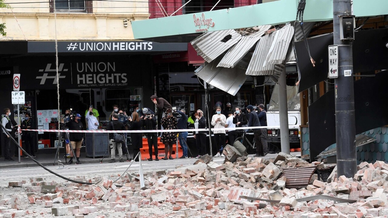
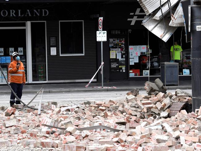
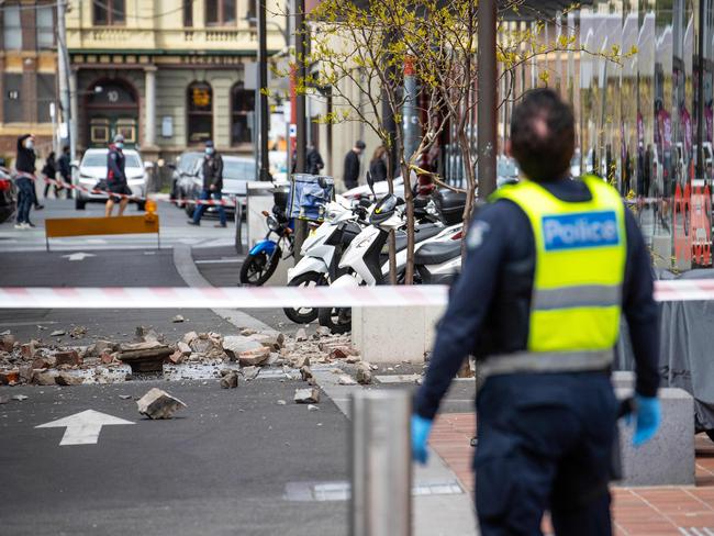
The 5.9 magnitude earthquake which shook south east Australia around 9.15am on Wednesday could be followed by aftershocks that measure up to 5.0 on the Richter scale, Geoscience Australia has warned.
Seismologist Spiro Spiliopoulos said it was very difficult to predict the timing and frequency of any aftershock activity, “but the rule of thumb is that you usually get aftershocks up to one magnitude less than the main one. So we could get aftershocks up to magnitude five.”
The number and severity of aftershocks varied greatly after big quakes, Mr Spiliopoulos said. An earthquake in Tennant Creek in 1998 was followed by “literally thousands of aftershocks”, he said, but there were “only a handful” of tremors after the 2017 Petermann Ranges earthquake.
Scientists said the 5.9 magnitude quake which struck at a depth of 10km near Licola North in the Gippsland high country was big for an Australian earthquake, and the largest ever recorded in Victoria.
But they stressed the event was a normal geological activity, and that while Australia had fewer earthquakes than many parts of the world, they did still occur here. About 100 earthquakes measuring 3 or more on the Richter scale are recorded here every year.
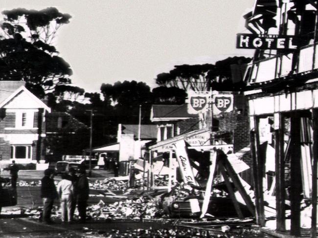
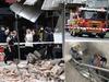
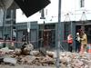
Australia’s most destructive earthquake occurred in the morning of December 28, 1989, when a 5.6 Richter scale quake shook Newcastle. Thirteen people died, 160 people were injured, 50,000 buildings were damaged and 300 had to be demolished.
More severe earthquakes than Newcastle have been recorded in Australia, including several that measured over 6, but they have generally been in remote areas and damage to people and property was limited.
The Gippsland region has experienced a succession of shakes in recent years, including a 3.4 disturbance in December 2014, one measuring 3.2 in April 2016 and another measuring 3.3 in February 2017.
The region was one of three identified in a 2018 Geosciences Australia hazard report into areas prone to earthquakes. South West Western Australia was deemed to be the area most at quake risk in that report, followed by the Flinders Ranges in South Australia.

Geophysicist Dr Ben Mather from the University of Sydney said Wednesday’s quake occurred on the Governor Fault, one of the deepest faults in Victoria. Usually the western side of the fault felt less quake activity than the alpine region to the east, he said.
“Earthquakes occur as a result of stress building up along a fault plane,” Dr Mather said.
“Over many many years, sometimes millions of years, the stress along a fault plane just accumulates and accumulates and eventually there’s a breaking point, and when that breaking point happens there’s a large slip event between rocks, deep into the ground.
“That slip event releases a lot of energy in the form of an earthquake.”
Australia does not regularly get earthquakes of Wednesday’s magnitude because the continent is not near any major tectonic plate boundaries, whereas New Zealand straddles the boundary between the Australian and Pacific plates, and gets many more.
Dr Mather said the Australian landmass consisted of three main rock formations, and the most active earthquakes tended to be on the eastern side of the continent, which featured the youngest rocks.
Wednesday’s earthquake was a “thrust fault,” which occurs when rock formations are pushed up against each other. Other geological movement can be caused by rock formations pulling away from each other.
Mr Spiliopoulos said Australia usually only gets an earthquake the size of Wednesday’s disturbance once every eight to 10 years, but interestingly, earthquakes in Australia tend to be felt across greater distances than earthquakes that strike in other parts of the world.
Wednesday’s quake was felt as far away as Adelaide, Tasmania, Canberra and Sydney.
“Because Australia is an old continent, seismic waves tend to travel very efficiently. They don’t get absorbed by what we call tectonic regions; there’s no hot rocks or lava, hot material which absorbs the energy. Seismic activities don’t get absorbed; they travel much more efficiently through cold material.”
Dr Adrian McCullum, Senior Lecturer in Geotechnical Engineering at the University of the Sunshine Coast, said Australia’s continental plate was moving northwards at about 7cm per year, and this motion built up stress which had to be released, most typically along fault lines.
“Inspection of the geological maps of Victoria shows a large number of faults in the Mansfield, Victoria region, thus it appears like an area where the release of compressive stress via an earthquake might be probable,” Dr McCullum said.
Professor Adrian Russell from the Centre for Infrastructure Engineering and Safety at the University of NSW said earthquakes were “an important consideration for Australia”.
“An earthquake of magnitude 7.5 is not unreasonable for calculations of earthquake risk at any location in Australia,” he said.
“Earthquakes of magnitude 5 or greater occur about once every six months and are sufficient to cause widespread damage if near our oldest cities and infrastructure.”
AUSTRALIA’S SEISMOLOGICAL HOT ZONES
NEWCASTLE

Australia’s most destructive earthquake, measuring 5.6, hit 15km southwest of the Newcastle CBD midmorning on December 28, 1989. Thirteen people died as a result, including nine in the Newcastle Workers Club, which collapsed. The Awabakal people of Newcastle also refer to movements of the earth in their Dreaming stories.
LAKE GEORGE
The vast and perennial Lake George sits atop a 75km fault line. In a 2018 Geoscience Australia hazard review, the Lake George fault was deemed to have high destructive capacity, due to its proximity to Canberra.
SOUTH WEST WESTERN AUSTRALIA
The Darling Fault extends for nearly 1000km north from Albany, making it one of Australia’s largest fault lines. Earthquakes in the region (and there have been some 40 significant ones since 2000) usually occur to the east of the fault line and tend to be at a shallow depth. One of Australia’s biggest ever quakes occurred at Meckerling, 130km east of Perth, in October 1968.
MOUNT GAMBIER VOLCANIC CHAIN
The 400km stretch between Mount Gambier in South Australia and along the Victoria coast towards Melbourne is Australia’s most active volcanic region. With 400 historical eruption sites, scientists believe it last erupted 5000 years ago – a blip in the world of geophysics.
FLINDERS RANGES
The Flinders Ranges was identified in a 2018 Geosciences Australia hazard report as second only to southwest WA for earthquake potential. Since 2000, SA has experienced more than 1600 seismic events, with a high level of seismicity along the Flinders Ranges, although most of the events would not have been felt by humans.
GIPPSLAND
Wednesday’s earthquake was the latest in a succession to strike the Gippsland region in recent years, including a 3.4 disturbance in December 2014, one measuring 3.2 in April 2016 and another measuring 3.3 in February 2017.
NORTHERN TERRITORY
The assumption that central Australia is geologically stable has been shaken, literally, by significant earthquakes in the past generation. In 1998 a series of three strong earthquakes hit Tennant Creek, followed by hundreds of aftershocks, and in 2016 another strong quake struck the remote Petermann Ranges, southwest of Alice Springs.
QUEENSLAND COAST AND HINTERLAND
University of Queensland research shows the state’s most earthquake-prone regions are along its central coast, and adjacent areas. Quakes struck Gayndah in 1883 and 1935, measuring 5.9 and 6.1 respectively, and an offshore quake measuring 6.3 caused damage to Rockhampton, Bundaberg and Gladstone in 1918.
LAUNCESTON
Serious earthquakes in Tasmania are rare but not unknown. In 1929 there were reports of a quake in Launceston, described by media at the time as “the worst on record, although of brief duration – lasting from 10 to 30 seconds.” Other accounts recall a series of earthquakes near Flinders Island in the late 1800s.
Originally published as Australia’s earthquake hot spots revealed
Join the conversation

‘It’s the point’: Cop blasts stranded couple
A young couple received a blunt response from police after their car became bogged on a closed road, leaving them stranded for three days.
Read more

Mum’s heart-wrenching tribute to 9yo son
The mother of a nine-year-old boy who died after becoming trapped between rocks at a beach on Easter has shared a heartbreaking tribute.
Read more