
Multiple tropical lows in the Top End to bring strong wind, heavy rain as Cyclone Watch declared for Gulf communities
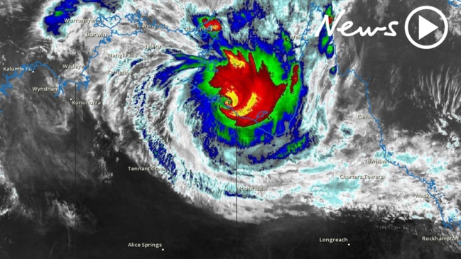
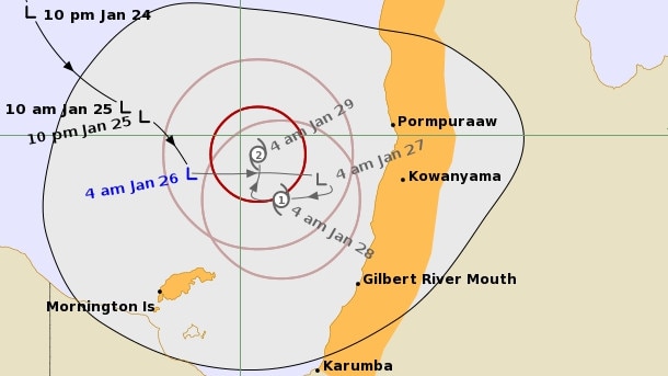
An intensifying tropical low in the Gulf of Carpentaria could turn into a cyclone late on Wednesday or early Thursday morning, the Bureau of Meteorology has advised.

News
Don't miss out on the headlines from News. Followed categories will be added to My News.
AN INTENSIFYING tropical low in the Gulf of Carpentaria could turn into a cyclone late on Wednesday or early Thursday morning, the Bureau of Meteorology has advised.
The tropical low is expected to be “fairly slow moving” over the next 24 to 48 hours before intensifying into a Cat 1 cyclone late on Wednesday or early on Thursday.
Meteorologist Rosa Hoff said the system is forecast to stay on the eastern side of the Gulf of Carpentaria as it intensifies to a Cat 2 cyclone.
MORE:
Tropical low near the Top End could develop into Cyclone Lucas in coming days: BOM
“This system is likely to have a significant impact on the environment around it and bring conditions like heavy rainfall, abnormally high tides and strong winds potentially even gales to the area,” she said.
If the tropical low does intensify into a cyclone, it will be named Lucas.
The slow-moving system could bring 100mm to 200mm of rainfall per day for multiple days according to BOM.
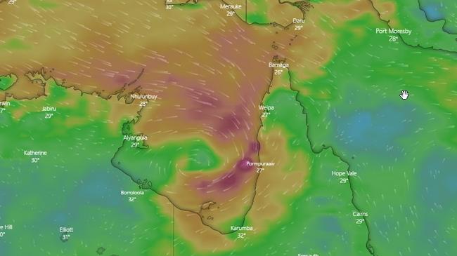
A tropical cyclone watch has been declared between Aurukun, Karumba and Mornington Island in Queensland.
Meanwhile, a deepening monsoon trough in the Top End and a tropical low is expected to form near the southern Daly District today.
Heavy rain and flash flooding is expected over parts of the western Daly and northern Gregory Districts on Tuesday night and into Wednesday.
Widespread 24 hour totals of 100-150mm are possible across the warning area, with heavier falls of 150-200mm near the coast, BOM has advised.
NT NEWS sizzling new deal: Get all your news for just $5 a month
Locations which may be affected include Wadeye, Nauiyu, Timber Creek, Dundee Beach, Palumpa, Peppimenarti and Newry.
Sammy’s heading home: Great sounds secured for Territory festival
One of the Territory’s first and best rock bands will be honoured at this year’s Barunga Festival. Check out who.

$2m package to attract international students to Top End
The funding will be used on programs to bring international students and skilled workers to the Territory and increase long-term retention rates.