
Bureau of Meteorology issues a new severe weather warning for FNQ
The Bureau of Meteorology releases a new warning for the Far North, citing potentially heavy rainfall, flash flooding and damaging winds.
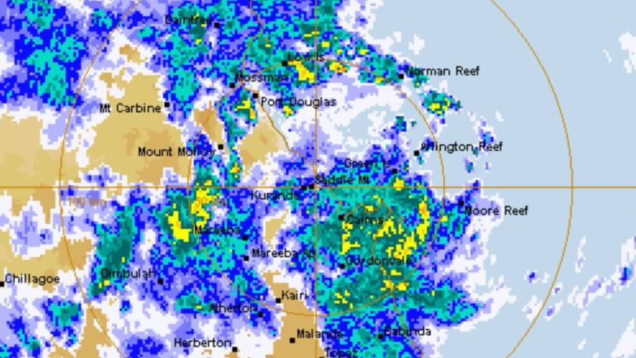
UPDATE THURSDAY, MAY 12 10AM: A new severe thunderstorm warning has been issued by the Bureau of Meteorology for the North Tropical Coast and Tablelands region.
BOM hazard response co-ordinator Brooke Pagel has warned that flash flooding could occur in some areas due to intense rainfall.
“We could be expecting some locally heavy rain with potential flash flooding due to the intense rainfall forming this afternoon or this evening.”
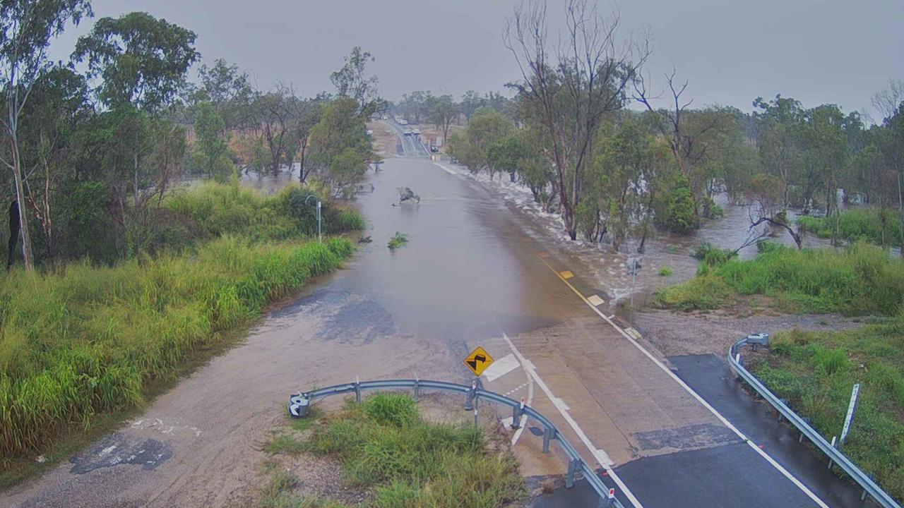
“A final flood warning is in place for Mulgrave River and Russell River, with a flood watch issued for Johnstone River.”
Ms Pagel says some areas may also experience damaging winds.
“It’s going to be very similar to what we’ve experienced over the last few days, with the added risk of damaging wind gusts.
The Bureau has advised motorists to stay off the roads if caught in areas of heavy rainfall.

UPDATE WEDNESDAY, MAY 11 3PM: EASING rainfall won’t necessarily mean immediate on-road safety for Far North motorists as a number of potholes begin to open up after three days of heavy rain.
After parts of the Far North recorded over 200mm in the 24 hours to Wednesday 7am, the remainder of the day was dry in comparison with no gauge picking up over 50mm from 9am to 3pm, Wednesday.
It comes after Cowley Beach, south of Innisfail reported 234mm in 24 hours, while staff at a Mourilyan Bakery described the rain as “mini cyclone” after the suburb received 90mm in one hour causing localised flooding.

While the easing conditions meant minor flood warnings for Far North rivers were less threatening, motorists will now have to drive with caution as Queensland Traffic reporting potholes on the Cairns Western Arterial Rd at Caravonica, the Captain Cook Hwy at Oak Beach, Riverstone Rd at Gordonvale and the Bruce Hwy at Babinda.
Although it’s likely a full assessment of the regions’ roads is yet to be undertaken, both Cairns Regional Council and Cassowary Coast Regional Council reported no emergency roadworks were required over the past three days.

“There were no major incidents reported to Council as a result of last night’s heavy rainfall,” CRC infrastructure and assets director Mark Wuth said.
“Council is undertaking repairs to reseal a part of Sydney St in Bayview Heights, which washed out overnight. Council recently installed a new water main and the sealing had not settled properly before last night’s heavy downpour.
“There were some minor landslips reported along Redlynch Intake Rd, and debris was removed from bridge at Ryan Weare Park in Freshwater and Peets Bridge in the Goldsborough Valley, which both briefly went underwater last night.”
A CCRC spokesman said the recent rain had led to an increase in customers requests, mainly for assistance with drainage issues.
“Once the weather has passed, Council will assess roads and floodways and arrange appropriate repairs where necessary,” the spokesman said.
Following the cancellation of a severe weather warning for all parts of the Far North on Wednesday, the region can expect dryer days heading into the weekend.
The Bureau of Meteorology is forecasting up to 4mm for Cairns on Thursday, and less than 1mm from Friday to Sunday, with maximums of 29C.
The return of the sunshine could not have come at a better time for music fans with the highly anticipated Red Hot Summer tour making its mark at the Cairns Showgrounds on Saturday.

The venue which only recently hosted the Cairns Expo is still recovering from wheel ruts and marks following the three-day lifestyle event, but Cairns Show Association secretary-manager Ian Moller-Nielsen said the surface damage wouldn’t impact the music festival.
“They started their preparation on Tuesday for the festival and (on Wednesday) they’re getting the stage up,” Mr Moller-Nielsen said.
“They’ve got marquees up and their preparation are going well. It will be in the Main Arena, so it’s not where the other event was.
“Hopefully the rain stays away and they can get the numbers they want.”
UPDATE WEDNESDAY, MAY 11 6.30AM: PARTS of the state were lashed by more than 200mm of rain overnight as an update was given on a severe weather warning for the Far North.
The Bureau of Meteorology has cancelled severe weather warnings for the North Tropical Coast and Tablelands, as the rain lashed coastal regions south of Townsville.
At 6.30am, the Bruce Highway from Townsville to Cairns had not been impacted by flooding, despite concerns of the road going under at Ingham.

Six-hourly rain totals of between 100 to 150mm are possible in coming hours, with Bowen, Proserpine, Hamilton Island and Airlie Beach now in the firing line.
It comes as 24-hour rainfall figures in parts the Far North have been released, with more than 234mm at Cowley Beach, south of Innisfail, 184mm at Innisfail and 190mm at South Johnstone.
Mourilyan Bakery employee Rachelle McLeish said the heavy winds gave a feeling of “a mini cyclone” yesterday as they prepared for another deluge today.
“The roads were full of water it was quite flooded to be honest,” she said.
“It was heavy winds too, so it was almost like a mini cyclone.
“We don’t normally get that much rain or thunderstorms in May, so it was quite unreal.”
BOM is predicting more showers to hit the region, south of Innisfail, today.
“It is very grey this morning, and some people are saying today is supposed to be worse than yesterday, so we will soon find out,” she said.
“You can’t see any trees or mountains at the moment, it is just white.”

Mourilyan Mobil staffer Maria Truman said “it rained cats and dogs” yesterday but it was only light drizzle this morning.
“Everyone is waiting for more rain to come, probably worse than yesterday, but at the moment it’s good,” she said.
“But it was like this (on Tuesday) and then just before midday it rained cats and dogs.”
TUESDAY, MAY 10 4.30PM: Cairns is expected to miss the large rainfall totals of the battered Cassowary Coast on today despite the possibility of a “triple figure” dump.
Metrologist Helen Reid, from the Bureau of Meteorology, said Cairns could still be in “for around 100mm” despite the bulk of the rain predicted to fall on Innisfail, Tully and Bowen.
Roads and backyards were under water in Innisfail yesterday morning as tradies downed tools and hit the pubs, with the town picking up over 100mm in one hour.
“The wet season has kind of arrived a little bit later than we are used to seeing,” Ms Reid said.
“We are looking at a couple of hundred millimetres tomorrow, not so much in Cairns which seems to be on the northern edge of all the action.”
The city can expect between the 60-70mm mark today, “but could still get over triple figures.”
Douglas Shire townships, including Port Douglas, Mossman and Daintree Village are expected to miss the heavy rain as a system in the west swings east and then further south along the coast.
It comes as roads and backyards were under water today, while tradies are off the tools and at the pubs across Innisfail with rain alerts around the town picking up over 100mm in one hour

While most of the state sits inside a Bureau of Meteorology warning zone on Tuesday, the Cassowary Coast was hammered with a midmorning thunderstorm resulting in localised flooding and massive hourly totals.
In the one hour to 10.45am, Mourilyan Mill recorded 113mm, while in the same period, north of Innisfail, 90mm was recorded at the McAvoy Bridge, and 102mm was recorded at the Garradunga Alert.
Garradunga Hotel owner of two years Steve Tyler said the suburb just north of Innisfail had copped an “absolute hammering” on Tuesday morning.
“It’s been the most rain we’ve had in two years of owning this pub, ridiculous torrential. Our whole backyard is under, the local roads are under, it’s definitely a lot worse than it usually is this time of the year.
“At about 10am it was at its hardest, and it went on for about an hour and a half, where we had visibility of about 10m.”
Mr Tyler said the heavy rain meant there were a “few wet rats” enjoying a lunch time beer on Tuesday.
“A few boys that were doing earthworks can’t get any work done and the cane farmers are loving it I hear. No so much the banana farmers, but as long as we don’t get the wind with it, we’ll be OK.”

Although the heaviest falls were outside the town centre itself, Innisfail major streets did not escape localised flooding, with local police warning of water over the road on the Bruce Hwy near the Palmerston Hwy intersection, on the Bruce Hwy at Goondi Bend, on Fitzgerald Esplanade and on River Ave at Haddrell Park.
Apart from Cowley Beach which recorded 76mm of rain from 9am to 2pm Tuesday, no Cassowary Coast location south of Innisfail had reported more than 50mm in the same period.
Bureau of Meteorology forecaster Helen Kirkup said while Innisfail was the focal point of Tuesday’s rain, greater activity was expected between Townsville and Mackay on Wednesday which “could make Cassowary Coast and Cairns look dry in comparison”.
“But we’re expecting more heavy downpours (for the Far North) on Wednesday, Cairns and Cassowary Coast could easily get triple figures, it’s likely to be more (than less).”
TUESDAY, MAY 10: THOUSANDS of residents north and south of Cairns are without power as heavy rain begins to settle in, causing hazards on Far Northern roads.
Since 5.55am, 1876 Ergon customers at Caravonica, Kowrowa, Kuranda, Mantaka, Myola, Oak Forest, Russett Park, Saddle Mountain and Smithfield have had no electricity.
However, at 8.20am, that number had reduced to about 1400 as Ergon crews worked to repair damaged lines caused by fallen vegetation.

And to the south, 577 customers at Goldsborough, Gordonvale and Little Mulgrave had been without power since 6.18am Tuesday. Although, this outage was briefly restored, an Ergon Energy spokesman said a fallen tree had again caused power loss to the same 577 customers just after 8am.
It comes as just about all of North Queensland sits in a severe weather warning zone which at 5am on Tuesday extended from Cairns, down to Bowen and out west as far as Cloncurry.
The Bureau of Meteorology was warning of six-hourly rainfall totals of 60-100mm for the warning zone.
At 8am Tuesday, the heaviest falls in the Far North had occurred south of Cairns with the Topaz Alert the only to record above 100mm with 107mm reported since 9am Monday.
The Babinda Boulders had recorded 90mm, Copperlode Dam had 88mm, and Cairns Racecourse received 33mm.
“From Wednesday, heavy rainfall which may lead to flash flooding is forecast to develop in parts of the North Tropical Coast, Herbert and Lower Burdekin, and Central Coast districts. Six-hourly rainfall totals between 100 – 150mm are likely,” the BOM’s latest severe weather warning read.
MONDAY, MAY 9: FAR North residents are warned to exercise caution this week as regions record rainfall of more than 100mm with showers forecasted to worsen.
Kimba Wong, senior meteorologist at BOM, said heavy showers hit FNQ in the past 24 hours, particularly in Cardwell with 117mm and Babinda Boulders with 102mm of rainfall.
Cairns had 24mm.
“We’re certainly looking at a series of wet days ahead,” Ms Wong said.
“We’re having some hefty rainfall totals come through.”
Tuesday is the start of the peak rainfall period this week and Cairns will have 45 to 70mm with chances of thunderstorms.
On Wednesday, rainfall will rise to 60 to 120mm before rapidly dropping to barely 1mm on Thursday.

Despite river catchment areas most at risk of flooding, Ms Wong said Cairns and greater inland areas are not in the clear.
“The flooding depends on where the heaviest rain ends up and there’s still uncertainty there,” she said.
Temperatures are also predicted to drop during the day and rise in the evening with warmer nights.
“Temperatures in Cairns will be in the high 20s which is cooler than they have been, the average maximum for May is 27 degrees,” Ms Wong said.
Warning residents to take care when out and about during heavy rain, Ms Wong said “if its flooding, forget it.”
“Check the radar if you’re planning outdoor activities,” she said.
EARLIER UPDATE MONDAY MAY 9: SEVERE weather warnings could be on the horizon for the Far North as the Bureau of Meteorology warns of a wetter week ahead, bring with it a higher risk of mozzie bites.
BOM duty forecaster Steve Hadley said Cairns and FNQ will have increased showers this week with temperatures averaging a maximum of 27.7C and a minimum of 20C.
On Monday, Cairns residents should pack their umbrellas with them due to the 90 per cent chance of rain, delivering up to 15mm, and a maximum temperature of 29C.
“It looks like a showery few days head for the Cairns area with potentially a few thunderstorms as well,” Mr Hadley said.
Mr Hadley said the bureau may be looking at issuing a flood watch and severe weather warning.

“Over the next seven days you can potentially see 200 to 300mm of rainfall in areas (north and west) of Cairns such as Mareeba and northern Tablelands and out towards Cape York,” he said.
Mr Hadley said the peak period of rain will be from Tuesday to Thursday with showers easing the rest of the week.
“Wednesday looks to be the peak,” he said.
As much as 100mm of rainfall is forecasted in Cairns on Wednesday with a sharp decrease to just forecast on Thursday.
With the heavy rainfall FNQ has experienced since late April, meteorologist Felim Hanniffy said the knock-on effect has been the swarm of mosquitoes and flies in the region.
“We’ve been having a lot more water so (the insects) have had more places to lay their eggs and now they’re hatching,” he said.

“More rainfall probably won’t help with that either.”
Another victim of the conditions is the Captain Cook Statue on Sheridan St which could face further FNQ’s delays to its move away from its current location.
The new owner, Anton Demolitions boss Martin Anton, said the removal is still scheduled for May 24 but he is wary of what the weather means for those plans.
“At the moment, it’s steering full course ahead but depending on the weather gods, we’ll revisit it at the end of next week,” he said.
“We hope it won’t be postponed but it’s looking that it might.”
Mr Anton said there seems to be a “late wet” season that no one predicted for the region.
“It’s typically unseasonal, (rain) hasn’t happened like this since probably the seventies,” he said.
UPDATE FRIDAY MAY 6: THE Premier Annastacia Palaszczuk has issued a severe weather warning for parts of Queensland, advising people in the Far North to prepare for “unusually heavy rain” with some areas expecting to receive their highest May rainfall on record.
“We are expecting some severe weather next week, most of this severe weather will be in Far North Queensland and out to the west of our state, and is going to be incredibly heavy rainfall” she said.
“It’s very unusual to see this type of situation occurring in Far North Queensland especially this time of year, which is usually near the end of the season.”
The Premier is providing a weather update following a briefing by the Bureau of Meteorology. @BOM_Qld https://t.co/3YfX9sNtIc
— Annastacia Palaszczuk (@AnnastaciaMP) May 6, 2022
The Bureau of Meteorology warns that areas between Cairns and Gladstone are expected to be the hardest hit.
Bureau of Meteorology community hazard officer Brooke Pagel said some areas in the region were expected to get as much as 300 millimetres of rainfall.
“There is a high chance that some areas in Far North Queensland may get their highest May rainfall on records, with some isolated areas on the Eastern seaboard between Cairns and Gladstone expected to get 250 to 300 millimetres or more of rain,” Ms Pagel said.

Meteorologist David Grant said the bureau would likely issue a flood watch for some areas on Sunday or Monday, with most of the rainfall coming early in the week.
“Be mindful that many watches and warnings will be issued by the bureau over the course of the weekend or into early next week, and please stay up to date with them as they are issued over the coming days,” he said.
“The most likely onset of this rainfall event starting on Tuesday.”
Those in the Cairns region who thinks of spending Mother’s Day outdoors, may want to rethink their plans says Ms Pagel.
“It will be very wet on Sunday, with showers all day unfortunately and also pretty gusty with 25 km p/h South-Easterly winds,” she said.
Bureau of Meteorology issues a new severe weather warning for FNQ
UPDATE WEDNESDAY 6.00AM: YOU can chuck the umbrella in the back seat for the next few days as skies over Cairns are set to clear slightly, but don’t place it too far out of arm’s reach as benign showers could still surprise.
The Bureau of Meteorology has forecasted mostly sunny condition on Wednesday and partly cloudy conditions for Thursday, with a maximum temperature of 30C and a 20 to 30 per cent chance of rain across the three days.
“The Far North has still got some showers around, mostly north and south of Cairns, but you’ll probably sweat more than you’ll get rained on,” BOM spokesman Steve Hadley said.

Unseasonably damp conditions continued to pound several regions over the weekend. Babinda Boulders saw the most intense rainfall with a 52mm drenching on Saturday, followed by Innisfail, which received 44mm on Sunday morning.
The not-so-dry season will deliver another lot of rain this coming weekend, though less intense. Cairns could see up to 10mm fall on Sunday.

“Some thunderstorms could develop, but it’s looking more like rainfall that you’d see during the cooler months. If you’re playing any dry-weather sports be sure to check the radar.”
A persistent La Nina event is likely to extend an already tardy wet season. The BOM is expected to provide more data on Thursday.
Cairns weather: Heavy rainfall and flood warning as towns cop over 100mm
UPDATE WEDNESDAY 12PM: DOUGLAS Shire residents have been told to use water sparingly in the wake of the heavy rain that pummelled the region, with water intakes experiencing blockage.
The regions treatment plants have been running at a reduced production capacity following the big wet in the Daintree, Mossman and Port Douglas across the Anzac Day long weekend, with silt, sand and vegetation “stopping a full flow of water.”
Council has asked for a conservative approach to water consumption due to the high turbidity levels capable of halting the treatment process, which is required to make clean and safe water.

Douglas Shire Mayor Michael Kerr said he expected things to be back to normal today.
“Everything floats down the rivers so you have all the branches and leaves, dirt and it all goes down the river and when it hits the area where it drops down into the catchment, it blocks,” he said.
“It causes a scenario where less water is actually going through to the plant to be processed, so they are constantly having to clear the filters to allow a normal amount of water to go in.”
Flooding also delayed the rubbish collection process in the Daintree Village and north of the Daintree River following more than 400mm of rain.
Waste bins will be collected today with recycling bins will be removed on Thursday.
UPDATE TUESDAY 12.30PM: DESPITE a relatively dry Tuesday across the Far North, some roads throughout the region are yet to reopen as flooding further south threatens the national highway.
At 12.30pm no coastal communities in the Far North had reported any rain, with some Tablelands towns receiving under 10mm.
But further south, the Far North is under threat of being cut off with the Bruce Hwy north of Ingham at the Seymour River down to one lane at midday Tuesday due to flash flooding causing water over the road.
Although, the adverse conditions are unlikely to have long-lasting affects with nearby Ingham Pump Station only recording 1mm of rain from 9am Tuesday, and the town expecting easing conditions on Wednesday.

Meanwhile in the Far North, heavy rain over the weekend closed Mossman Mt Molloy Rd (Rex Hwy) at the Bushy Creek causeway, with water still over the road on Tuesday.
Cape Tribulation Rd at Cape Tribulation had also been closed to all traffic due to heavy rain and flash flooding and Esplanade Upper Daintree Rd between Noah and Upper Daintree was also closed due to boggy conditions.
The heavy rain over the five days from Thursday to Monday also meant a busy period for rescue crews with Queensland Fire and Emergency Services reporting 24 SES assistance jobs over that period.
A QFES spokesman said those 24 jobs were mostly minor and related to assistance with tasks such as fallen trees and sandbagging assistance.
“The noteworthy job we were involved in was with assisting QAS with a patient across the Daintree River on Sunday night,” he said.
“Because the ferry was closed and the patient needed to come across for treatment, we had our flood boats, but QAS was the lead agency.”
TUESDAY 10AM: DAINTREE residents have been forced to chainsaw their way out of flood affected properties following the Anzac Day rain, with the cable ferry resuming service this morning.
Douglas Shire Council workers have removed debris off the cable lines after more than 400mm poured down over the long weekend period.
Tour operator David White said there was still no power at the Daintree Village but the flood waters were dissipating following an “out of control” overnight dump.

“We had a lot of rain last night, it was the heaviest of the whole lot,” he said.
“We had a landslide in our front driveway, I had to chainsaw my way out of the driveway this morning to get to work.
“The last two days we’ve had to cancel bookings, it was just out of control.”
Douglas Shire Mayor Michael Kerr said workers had been monitoring roads in the rainforest and had been working hard to minimise traffic disruptions.

A moderate flood warning is still in place for the Daintree River.
“Motorists need to take care when travelling on the roads today as plenty of water, mud, debris and potholes on the roads creating hazardous driving conditions,” he said.
“Our crews are working to safely re-open priority roads and crossings, so we ask for the community’s patience and co-operation while we work our way through this.”
Mr White said the Daintree River was “still flowing fast” as the tide started to go out.
“It will get faster as the tide starts to go out, there big tides at the moment but it is doable.
“It is going down so it should be fine as the day goes on.”
TUESDAY 9AM: FOR the first time in almost a week, Far North residents didn’t require an umbrella as the thick cloud coverage eased with the sun finally returning.
With the Bureau of Meteorology’s radar displaying a clear coast line all the way across the Far North at 9am Tuesday, the threat of triple-figure falls and flooding has dissipated.

The calmer conditions come after a five-day hammering from April 21 to April 25 where Cairns Airport recorded 204mm, Daintree Village reported over 400mm in that period, Cairns Racecourse had 300mm and on the Cassowary Coast Innisfail reported 212mm.
And although Tuesday has begun with clearer skies, the BOM is still forecasting showers for the region, with up to 5mm predicted for Cairns.
The Bureau is forecasting a high chance of showers for the North Tropical Coast on Tuesday and Wednesday, with the possibility of rain easing from Thursday.
MONDAY 11.30AM: Emergency food drops have been delivered to stranded Cape York travellers cut off by swollen rivers as a late wet season rain bomb detonates over Far North coastal communities.
Three families visiting the Portlands Road area north of Lockhart River were trapped at the weekend in between the Pascoe and Wenlock rivers.
Cook shire Mayor Peter Cook said a helicopter organised by the Queensland Fire and Emergency service took off from the Archer River Roadhouse stocked with food supplied by a Coen storekeeper.

“They got caught between the Pascoe and Wenlock rivers and they were running out of food,” he said.
“We got a little mustering helicopter that took off from the Archer River Roadhouse.
”It’s a process we go through every second year.
“In the past 10-years it has been getting later and later and April is when we got the cyclones (a few years ago), it’s stretching out and changing, (the wet) is getting later and later each year.”
Around Cooktown Cr Scott said the Little Annan River was up and down with the rain but the airport road was still passable.
“It’s been raining steadily and the ground is absolutely saturated,” he said.
“Myall Creek and Archer Rivers are up and the Pasco and Wenlock rivers are very high.”

In the past 24-hours the Coen Racecourse copped 128mm as the Department of Transport and Main Roads issued a hazard alert for Myall Creek at Mission River which is closed for maintenance and the cleaning of debris.
The Peninsula Developmental Road is closed from Coen Airport to Weipa, water is over the bridge at the Archer River Roadhouse, and the PDR is impassable north of Coen.
The Mulligan Highway at the McLeod River as of 10.30am was impassable as the river level reached a height of 0.60m.
Cape York police issued a warning notice to travellers about the danger and urged motorists to check local council websites for localised flooding and road closures as well as using the TMR road report website for updates.
Further south the Daintree River ferry remains out of action.
Douglas Shire Mayor Michael Kerr said the usually gentle waterway had been transformed into a torrent after 563mm of rainfall was dumped on the region in the past four days.
“The river is flowing so fast it’s not safe for the ferry to run,” he said.

“The catchments are full and all the water is flowing straight into the river.
“It’s just not safe to operate it.
“We notified all the emergency services and there is an ambulance posted (on the (northern side of the river.)”
Despite 24-hour totals measuring 43mm at the Cairns Airport, 100mm at Mount Sophia (near Behanna Gorge) and 42mm at Gordonvale, all flood prone roadways remain passable, according to Cairns Regional Council flood cameras.
However Peets Bridge at Goldsborough over the Mulgrave River is close to going under.

UPDATE MONDAY 8.30AM: MULTIPLE roads north of Cairns have been flooded due to heavy rain with the Daintree Village recording the region’s highest 24-hour total.
Between 9am Sunday and 9am Monday, 212mm of rain fell at Daintree Village with 150mm of that total falling in seven hours on Sunday.
In it’s latest flood warning for the Daintree River, the Bureau of Meteorology said the river at Daintree Village was at 7.25m and was expected to peak on Monday morning.

Douglas Shire Council has reported the Daintree Ferry which closed on Sunday will remain closed until flooding eases.
Ferry operators inspected river conditions on Monday and deemed the conditions as too dangerous to operate in while also reporting debris on ferry cables.

DSC also reported road approaches to the crossing were becoming inundated with floodwater, while the road to Daintree Village was flooded at Barratt’s Creek Bridge, south of the village and Cape Tribulation Road at Noah’s Range was also closed due to a fallen tree.
While no roads south of the Daintree were reported as flooded, the BOM had placed multiple coastal catchments from Ingham to the Daintree on a flood watch.
Catchments likely to be affected included: Daintree River, Mossman River, Barron River, Mulgrave and Russell Rivers, Johnstone River, Tully River, Murray River and Herbert River.
Far North 24-hour totals 9am Sunday to 9am Monday
Daintree Village – 212mm
Diwan – 175mm
Craiglie – 62mm
Saddle Mountain Alert – 69mm
Cairns Airport – 44mm
Cairns Racecourse – 72mm
Japoonvale – 112mm
Bulgun Creek Alert – 125mm
SUNDAY 9.54AM: The Daintree River Ferry will close from 6pm on Sunday due to flooding in the Daintree River creating unsafe conditions at night.
The Bureau of Meteorology has issued a moderate flood warning and forecast heavy rainfall to continue for the next 36 hours.
Debris has been reported flowing down the river and road approaches to the vessel are expected to become inundated later on Sunday as water moves down the river.
“At this stage, if conditions allow, the ferry will resume when daylight comes at 6am on Monday,” Douglas Shire Council said in a statement.
The road to Daintree Village is flooded with Barratt’s Creek Bridge, south of the village, unable to be driven on.
SUNDAY 7.16AM: Thunderstorms are still on the cards for Cairns despite predictions of significant rainfall failing to pan out overnight.
The Bureau of Meteorology still had flood warnings in place across much of the Far North on Sunday morning:
■ Moderate Flood Warning for the Daintree River and Flood Warning for the Mossman River
■ Minor Flood Warning for the Tully River and Flood Warning for the Murray River
■ Flood Warning for the Russell River and Final Flood Warning for the Mulgrave River
■ Flood Watch for areas of western Queensland
■ Flood Watch for Coastal Catchments from Ingham to the Daintree

Cairns Airport only recorded 1.8mm of rainfall between 9am on Saturday and 7am Sunday, with Cairns Racecourse in Woree notching up 12mm.
However, areas of the Cape received a drenching with the bureau’s rain gauge at Lockhart River recording 176.6mm.
Overnight rainfall (9am Saturday to 7am Sunday)
■ Lockhart River – 176.6mm
■ Coen – 57mm
■ Cardwell – 49mm
■ Cooktown – 45.4mm
■ South Johnstone – 17.4mm
■ Cape Flattery – 14.6mm
■ Low Isles – 13.2mm
■ Cairns Racecourse – 12mm
■ Cowley Beach – 10mm
■ Innisfail – 6.8mm
■ Cairns Airport – 1.8mm
■ Mareeba – 0mm
The Douglas Shire Council has issued an alert saying Daintree River ferry services would likely be disrupted due to the flood warning.
“Heavy rainfall is expected to continue through the long weekend following widespread rainfall totals of 125-240mm across the Daintree and Mossman River catchments in the 48 hours to 9am Saturday,” the statement said.
“Since 9am Saturday, rainfall totals of 110-160mm have been recorded in the Daintree River catchment, with much of this recorded since late Saturday evening.
“The Daintree River is 5.25m high at Daintree Village and rising.
“Catchments are now saturated, and river levels are expected to remain high over the next few days.”
The Douglas Local Disaster Management Group will work closely with the ferry contractors to monitor conditions and is encouraging everyone to avoid travelling in the area.
Access to Daintree Village is also expected to be cut off at Barratt’s Creek Bridge, south of the village.
UPDATE SATURDAY 1.40PM: Traffic came to a standstill after a rental car rolled on wet Cairns highway with authorities warning more wet weather could be on the way.
A single vehicle crash resulted in a rollover on Captain Cook Highway at Holloways Beach with two patients walking away with minor injuries.
Queensland Police and Ambulance were on the scene with traffic cleared at 1pm.
The Bureau of Meteorology have warned that the trough is sitting off the coast which means showers on Saturday for the Far North region, with a focus on Lockhart River area.

“As we go into tomorrow, that trough will move south a bit more, we’ll see more showers,” BOM metrologist Helen Kirkup said.
“On Sunday night and Monday, we will see an increase in rainfall in the Cairns area.”
UPDATE SATURDAY 11AM: The Bureau of Meteorology has lifted a severe thunderstorm warning for the Lockhart River area as of 9.10am Saturday.
The decision came after thunderstorm activity eased in the eastern peninsula.
“The immediate threat of severe thunderstorms has passed, but the situation will continue to be monitored and further warnings will be issued if necessary,” the bureau stated.
■ However, flood warnings were still in place for the following areas:
■ Minor Flood Warning for the Tully River and Flood Warning for the Murray River
■ Flood Warning for the Mulgrave and Russell Rivers
■ Flood Watch for Coastal Catchments from Ingham to the Daintree
■ Initial Flood Watch for parts of the Gulf Country and western inland catchments
■ Initial Minor Flood Warning for the Daintree River and Flood Warning for the Mossman River
UPDATE SATURDAY 9AM: Road closures have been reported across the Far North as heavy rainfall and localised flooding causes traffic havoc.
Queensland Traffic issued a road closure alert for Bonnie Doon Rd in Mossman at 10.06am, with both lanes affected.
Roads were also flooded at Mossman Mt Molloy Rd (Rex Highway) at Julatten, Finlayvale Rd at Finlayvale and South Johnstone Rd in South Johnstone.
Foxton Ave in Mossman was closed due to flash flooding at 6.40am.
Authorities have warned motorists not to drive in floodwaters and to remain vigilant with flood warnings current across the region.
SATURDAY 7.40AM: Multiple weather warnings have been issued for severe thunderstorms, marine wind and flooding amid forecasts for intensifying rainfall across the Far North.
Cannon Park Racecourse in Woree recorded one of the highest rain readings overnight with 131.2mm from 9am Friday to 7am Saturday.
It was followed by Cairns Airport (102mm), Innisfail (96.2mm) and South Johnstone (95mm).
The Bureau of Meteorology issued a severe thunderstorm warning for parts in the Peninsula forecast district with heavy and persistent thunderstorm activity occurring around Lockhart River.
The warning, issued at 6.13am on Saturday, stated flash flooding was possible over the next several hours at Lockhart River.
In the Far North, strong wind warnings were current for South East Gulf of Carpentaria, Peninsula Coast, Cooktown Coast and the Cairns Coast.
Several flood warnings have been issued, with minor flooding possible at Daintree Village on Saturday morning after rainfall totals of 123mm overnight – following totals of 100-160 mm across the Daintree River catchment in the 24 hours to 9am Friday.

A flood warning was also issued for Mossman River, Mulgrave River, Russell River, Tully River and Murray River.
An initial flood watch has been flagged for parts of the Gulf Country and western inland catchments with a trough in the far west likely to deepen over the weekend and early next week, producing heavy rainfall and areas of flooding.
“The majority of catchments in the area are relatively dry due to lack of significant rainfall observed across the Flood Watch area in the past few weeks,” the bureau said.
“Areas of minor flooding are likely across the Flood Watch area from Tuesday, with isolated high levels possible in association with heavier areas of rainfall.
“Localised flooding and disruption to transport routes are likely.”
Far North Qld overnight rainfall (9am Friday to 7am Saturday)
■ Cairns Racecourse (Woree) – 131.2mm
■ Cairns Airport – 102mm
■ Innisfail – 96.2mm
■ South Johnstone – 95mm
■ Ravenshoe – 67.4mm
■ Cowley Beach – 44.2mm
■ Weipa – 24.6mm
■ Mareeba – 23.4mm
■ Low Isles – 8.6mm
■ Scherger – 0.2mm
Flood warnings as of 7.40am Saturday
■ Minor Flood Warning for the Tully River and Flood Warning for the Murray River
■ Initial Minor Flood Warning for the Daintree River and Flood Warning for the Mossman River
■ Initial Minor Flood Warning for the Mulgrave River and Flood Warning for the Russell River
■ Flood Watch for Coastal Catchments from Ingham to the Daintree
■ Initial Flood Watch for parts of the Gulf Country and western inland catchments
More Coverage


Originally published as Bureau of Meteorology issues a new severe weather warning for FNQ

Cairns passengers stranded as aircraft grounded over software bug
