
BoM forecasts week of high temperatures
While Australia’s eastern states deal with heavy rain and flooding, the Bureau of Meteorology has issued a weather alert for the Territory.

Business
Don't miss out on the headlines from Business. Followed categories will be added to My News.
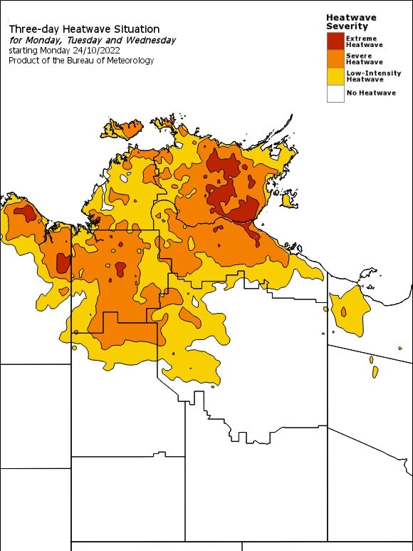
The weather Bureau has issued a heatwave warning for the Northern Territory’s Top End until at least Wednesday.
The Bureau of Meteorology is predicting higher than average temperatures in Darwin and the outer Darwin area up to 35C until Saturday, with overnight minimums to range between 27 and 28 degrees.
The warning was issued at 2.04pm Sunday and extends to Wednesday. It follows similar warnings over the past two days.
The BoM advises that areas likely to be heatwave conditions include Borroloola, Darwin, Dundee Beach, Humpty Doo, Katherine, Lajamanu, Nauiyu, Palmerston, Wadeye and Wurrumiyanga.
An extreme heat warning has been issued for Tiwi, Arnhem and Gregory districts, while a severe heatwave warning has been declared for Daly, Carpentaria, Barkly and Tanami districts.
The Bureau said hot temperatures were expected around the clock.
“Maximum temperatures in the high 30s to low 40s and overnight minimum temperatures in the mid to high 20s will be experienced over much of the northern half of the NT in the coming days,” the BoM said.
“Heatwave conditions are expected to increase in area and intensity over the next few days.
The bureau has urged Territorians to take care during the heat event.”
Territorians responded to the hotter temperatures and high humidity by staying inside.
Traders and browsers at Nightcliff’s Sunday market sweltered from its 8am opening and by midday many people were feeling the heat.
Stalls usually four-people deep at lunchtime were noticeably thin for shoppers and Verbena St, where parks are filled by market visitors on Sunday, was almost empty of vehicles by midday. The market usually wraps up by 2pm
Market manager Ross Dudgeon said the heat kept people away.
“There’s a breeze here but a lot of people just go ‘nah, it’s too hot’,” he said.
Darwin bureau senior meteorologist Billy Lynch said Nightcliff’s midday temperature of 33C actually felt like 36C and described the heat as “oppressive”.
“The apparent or feels like temperature was 36C and there was no cloud cover so if anyone was in the direct sun, it would have felt even hotter,” Mr Lynch said.
“Principally, the heat is caused by the lack of cloud cover and this is because atmospheric conditions are not right for showers and thunderstorms to form because there is too much dry air above the ground where the clouds form.
“The extra humidity is due to stronger than normal westerly winds which push moisture from the Timor Sea over Darwin. For these reasons Darwin and the entire north of the NT is in a heatwave.”
A change may be a week away.
“The hotter weather will pass once we have a return to wet season showers and thunderstorms, which will bring cloud cover and cooler temperatures,” Mr Lynch said.
“However, it is normal during the ‘build-up’ months to have periods where it does not rain and this is what’s occurring now. We will have to wait at least another week before this hotter weather will pass.”
The Bureau has warned Territorians to stay out of the heat.
“The BoM website advises Territorians to find a cool spot to ride out the high temperatures.
“Seek a place to keep cool, such as your home, a library, community centre or shopping centre,” it said.
“Close your windows and draw blinds, curtains or awnings early in the day to keep the heat out of your home. If available, use fans or airconditioners to keep cool.”
Across the Territory, the Bureau said it would also be hot across central and southern parts of the NT, with thunderstorms spreading throughout much of the southern Territory from Tuesday.
The Bureau said thunderstorms would be gusty and severe thunderstorm warnings might be issued.
Fire danger will be high across parts of the NT this week including Darwin, Adelaide River, Katherine and southern NT.


Election shock: Political party’s preference call channels donkey vote
The Greens have made an unexpected preferences announcement. Read why they did it.
The NT’s small business stars shine at national awards
Two Territory businesses have won honours and a swag of others reached finals at the national small business ‘Oscars’. Read who won.