
Nullarbor camel traffic jam
FIND the pioneering spirit of adventure by racing across South Australia on camel ... but only if you can get them moving.

THE camel, we are told, is a horse designed by a committee. And now these three guys, with almost regal stupidity, had our "committee" of 14, in three vehicles, crawling through the desert behind them in slo-mo procession, totally at their whim.
Sometimes they galloped at 35km/h. Sometimes they walked. But mostly they trotted, single file, legs on each side swinging in sync like pacers at the trots, rocking side-to-side in unison, the fringes on their humps a-flutter.
They could have been entering the straight at Harold Park, with a pace car behind, not in front of them.
There was no way they were going to leave the red sand of the wheeltracks and subject their soft pads to the uncertainties of prickly spinifex and mulga stakes.
And there was no way we were going to attempt to pass, risking a kick that has been known to wreck panelwork and bend door pillars.
After more than an hour and almost 30km, they were obviously bored. They stepped aside and peered at us disdainfully down droopy noses as we continued our desert journey.
OUTBACK TOURS
Our journey had begun in Broken Hill, with a 1400km shakedown drive across South Australia to where our desert adventure really began: at the head of the Great Australian Bight.
We turned off the Eyre Highway to watch a dozen southern right whales cavorting in a sparkling ocean before taking on extra fuel and water at the Nullarbor Roadhouse.
Then we turned right from the highway – our last "blacktop" road for 3000km – and headed north towards the Great Victoria Desert.
Our first day was spent on the grey-green, flat-line immensity of the Nullarbor. It's featureless apart from Cook, a village on the transcontinental railway that lost its usefulness when there was no longer need to water steam trains.
Now it's a railway siding where immense goods trains wait for other immense goods trains to pass on the single-track line.
Cook's population is now reputedly two. I can vouch for one, because I saw him – the last person we would see outside our group for several days.
After Cook, the thin veneer of sand on a limestone plateau gradually changed to mulga and sandhills – endless, parallel ridges like ripples in an inland sea.
Out here, you have to adjust your focal length. At first, the landscape can look endless, useless, even hopeless. But if you re-focus from the harsh immensity, your universe can resolve to a single petal of a desert fuchsia, or an ant-line in the red sand.
And if you tune beyond the crushing silence, you can hear the song of the black oak as a breathless sigh moves from the surrounding mulga – so soft that even the mournful call of the pallid cuckoo can be intrusion and the tuneless chatter of zebra finches can be cacophany.
This is beyond the "outback", with its scattered settlements and stations. The desert emptiness is almost complete, with only a handful of Aboriginal communities and mining camps in square kilometres measured in hundreds of thousands. Six days and 1200km from the Nullarbor Roadhouse, we had seen only two other vehicles.
The map is a dot painting of insignificant detail. Dotted lines show "highways" that are sandy tracks. A dot for a mountain turns out to be a low, rocky outcrop; the wandering line of a creek just a dusty dip in the sand; and a patch of blue for a lake is caricature of a salt-crusted clay pan.
LAST OF THE GREAT EXPLORERS
We were on the track of Len Beadell, last of the great explorers. His track led north, through a conservation park named Unnamed. We knew we were there because of the name on the sign – Unnamed Conservation Park, it said, announcing a 21,000sqkm reserve about the same size as Israel or Slovenia.
It wasn't the only incongruous sign. Where our sand track crossed another, the thoughtful authorities had a erected a "give way" sign at a crossroads that would have been lucky to see a handful of vehicles a year.
From time to time there was a Beadell marker, usually a beaten-flat can mounted on a stump, with compass bearings and a 1961 date stamped on it, carefully maintained by the pioneer's family.
We also passed a restored marker left by Ernest Giles, the first explorer in these parts, in 1875.
We turned west at a place called Volkes Hill (there's no hill in sight) where, at another give-way sign our track met the Anne Beadell Highway – 1350km of sandy wheel tracks from Coober Pedy to Laverton, named with wry humour after the road-builder's wife.
In South Australia, Beadell's name for the track remains on the map, but in Western Australia, bureaucracy simply refuses to acknowledge the name because Anne Beadell is a "living person". Wow!
From time to time, we came across Aboriginal wells, usually damp earth at the bottom of a shallow hole, and gnamma holes, underground rock reservoirs that mostly looked dry but once supported life.
After six nights of desert camping, we trundled into Laverton, a one-pub village on the edge of Western Australia's eastern goldfields.
Showers and cold beers aside, there wasn't much to recommend Laverton, a former gold town that survives as a base for geologists and other resident mining people.
We were keen to be off. Ahead of us to the north, the Gibson Desert beckoned – more sand, more rock, more mulga, more awesome vastness – before our next brush with civilisation at Uluru.
The Sunday Telegraph
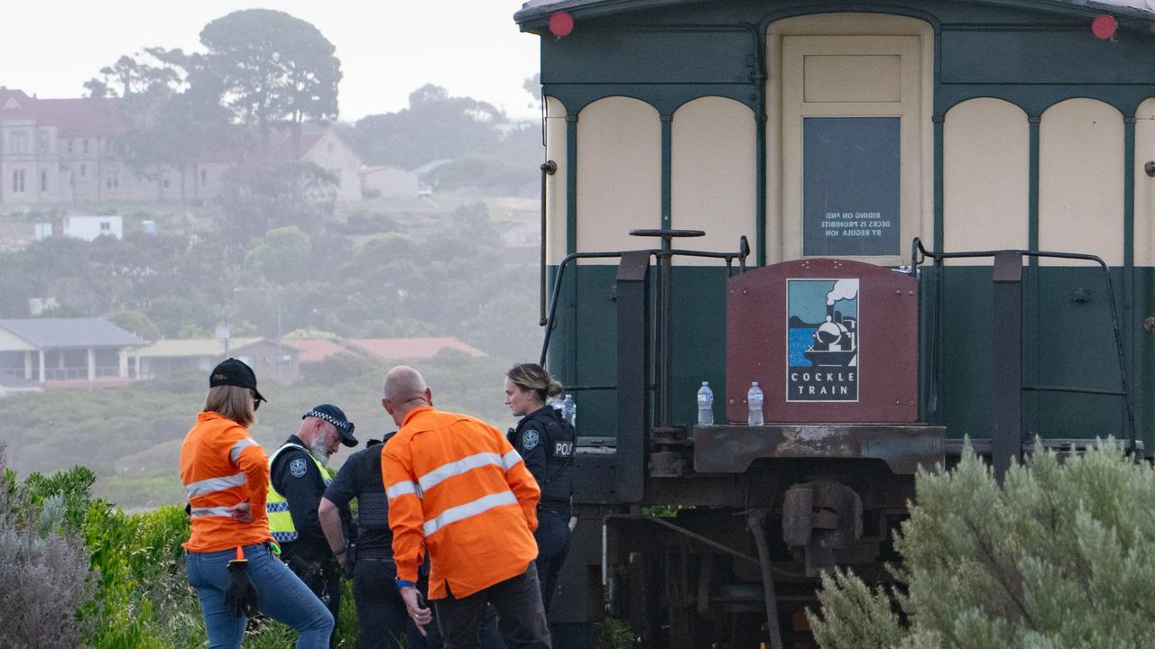
‘Absolute tragedy’: Train hits 89yo tourist
Distressed passengers watched on in horror as the 89-year-old was struck and killed by the packed tourist train.
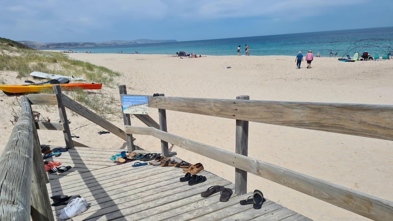
Detail in Aussie beach pic stuns internet
An image of an Australian beach is doing the rounds online but there’s one detail that has people talking.
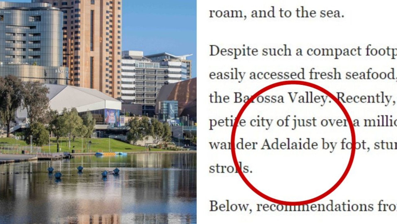
‘Surprise’ Aussie city Americans raving about
Do you agree that this “underrated” Australian city is the “coolest” in the country?