
Weird weather ‘anomaly’ making Sydney choke
Sydney is enduring ominous conditions, with ash and charred leaves falling from the sky. A bizarre weather pattern is making things far worse.

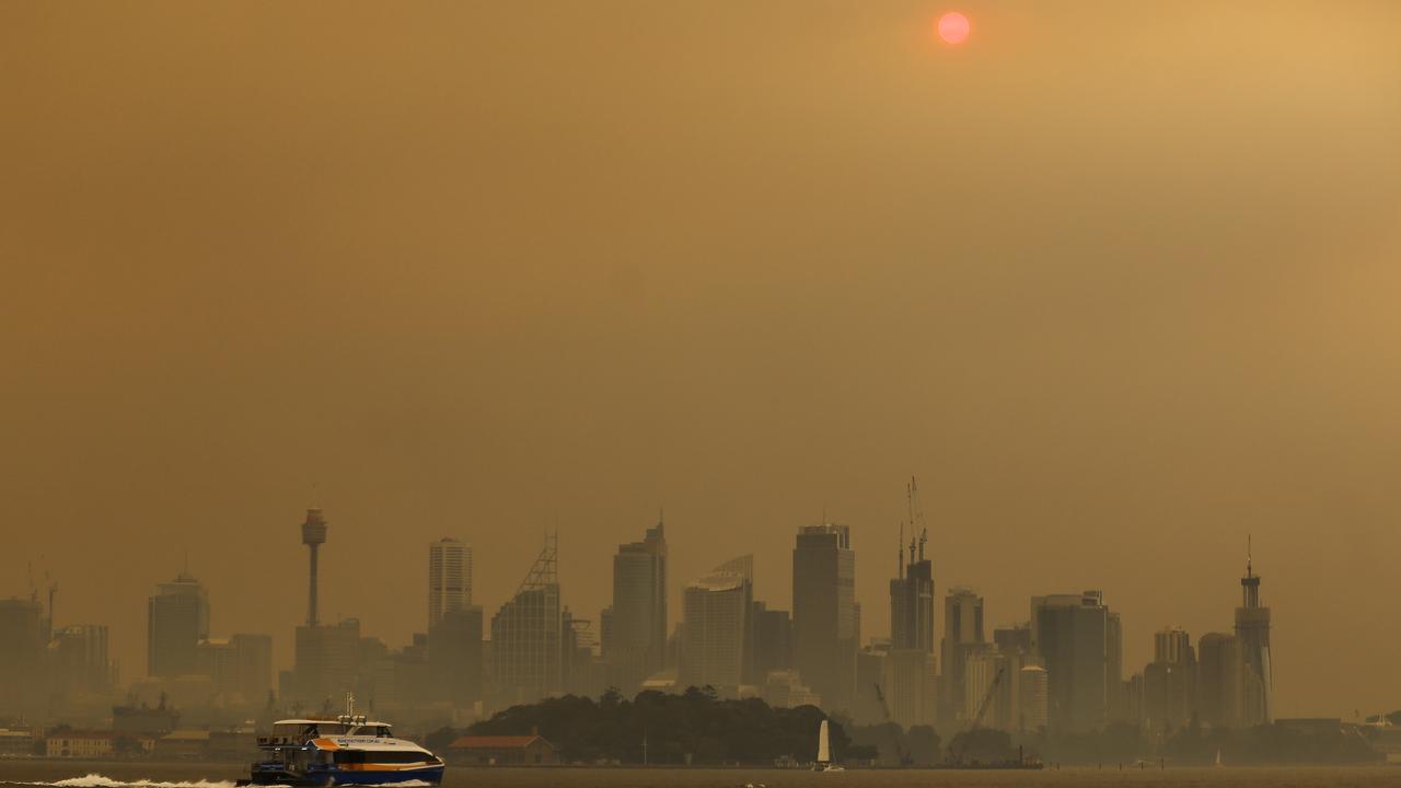
For Sydneysiders it was one bizarre scene after another. More than a week ago the sky turned from its usual crisp blue to a sickly yellow.
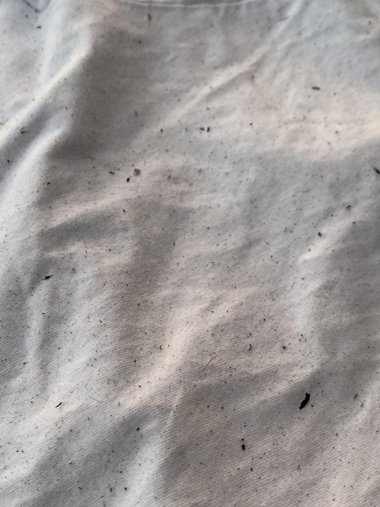
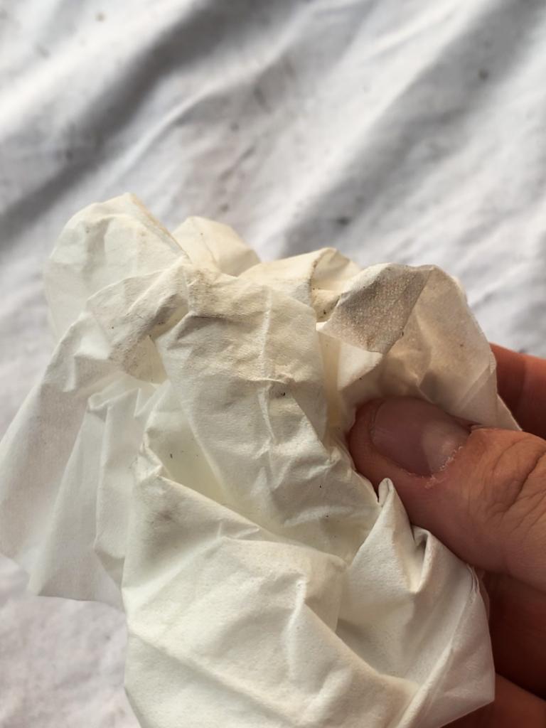
Next the sun turned a deep shade of red. Flecks of ash then descended on washing lines, smearing clean white linen a dirty grey, muckier than before it was washed.
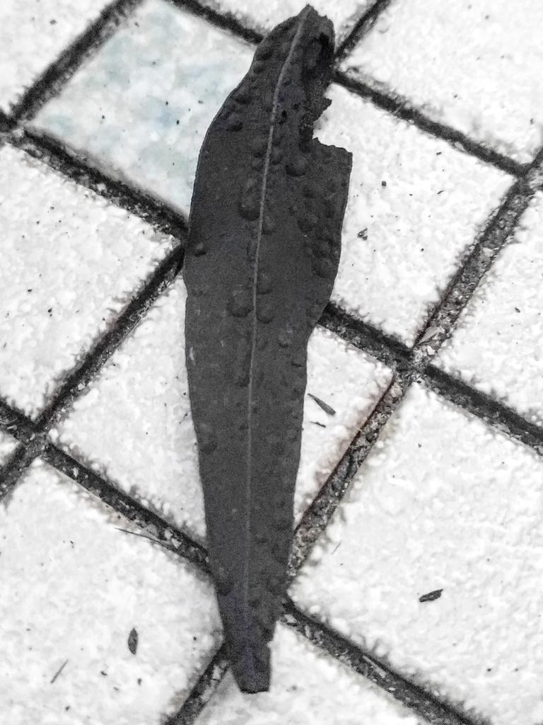
By Friday, whole blackened charred leaves were landing in gardens almost 100km from the fires that were beginning to lick the fringe of Sydney’s outer suburbs.
New South Wales’s cough-inducing weather lies in the bushfires, for sure. But also due to an “anomaly” in the dance that takes place between our various climate drivers.
That dance has gone haywire. Effectively, Australia’s weather still thinks its winter and that’s messing lots of things up.
I had cleaned my balcony last night. This morning I came out to this. It's everywhere, on the plants, the seats, the windows. It must have traveled hundreds of kms through the air to arrive at Botany Bay 😠#NSWfires #Sydneysmoke pic.twitter.com/aj4vw9tQQI
— iris sandwalker 👣ðŸšðŸƒ (@irisherself) December 5, 2019
Iris Sandwalker, who lives in the southern suburb of San Souci, noticed the first petrified gum tree leaves, the colour of tar, on Friday.
“I’d only just cleaned the balcony the night before and my heart sank when I saw them. I had a bit of a sob about the whole thing,” she told news.com.au.

From Ms Sandwalker’s balcony the views of Botany Bay have vanished, replaced by a jaundiced wall of smog.
“What makes me sad is the thought that what is burning there now, and the ash that’s landed here, may never return. It feels like its goodbye to those dense ecosystems that I once met travelling through Australia.”
NSW’s stretch of polluted weather is now both the longest and most widespread in the state’s history – worse than the Black Christmas or 1994 Sydney bushfires.
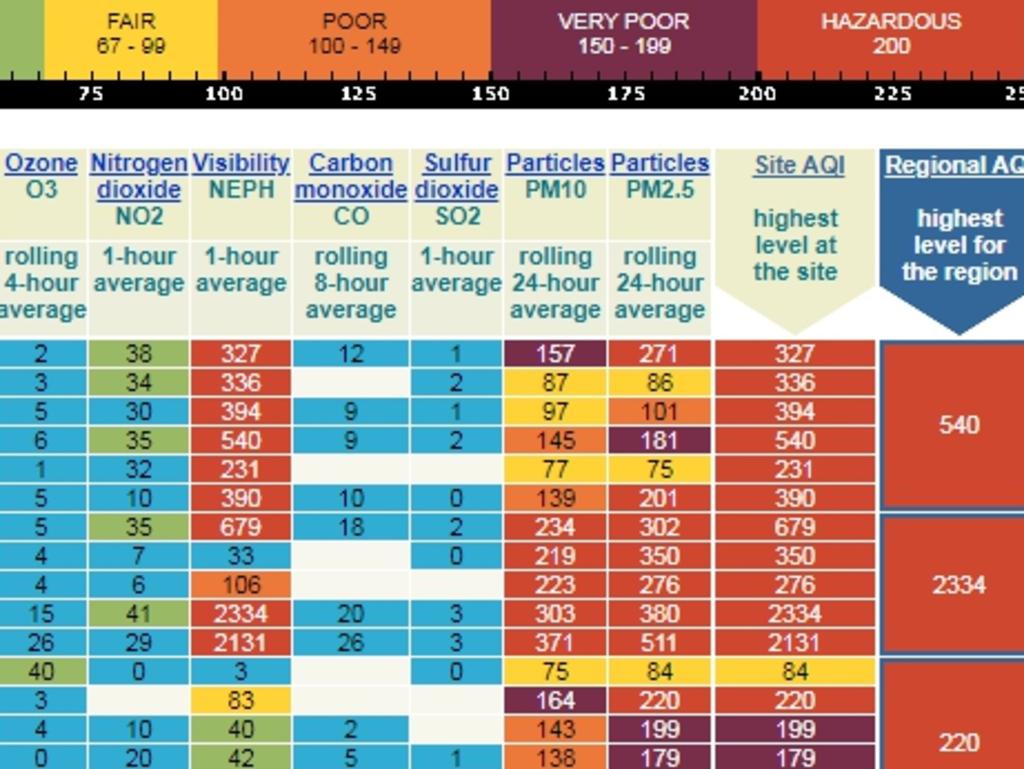
On November 22, nearly every part of Sydney recorded hazardous levels of air quality, a feat not seen for a decade.
In Newcastle, the smog was so thick it was the equivalent of smoking 36 cigarettes if you had stayed out all day.
A few weeks ago on the left, today on the right. #sydneysmoke pic.twitter.com/00OUe9gJJy
— Kane Sutton (@KaneSutton92) December 2, 2019
Poor air quality, it’s raining ash. Sydney is choking! We need some rain #NSWbushfires pic.twitter.com/O7gJCMoUSL
— Alex Contreras (@AlexC0ntreras) December 3, 2019
Air pollution is measured by particle size in micrometers.
A human hair is 50-70 micrometre in diameter; pollen is 10 micrometers. The particles that are really bad are those that are a mere 2.5 micrometers wide – the kind of particles caused by bushfires. These can easily be ingested and can slip through most face masks.
Anything above 200 PM2.5 particles per cubic metre of air is considered hazardous. On some days, the air in the city’s west has been so been choked it’s reached more than three times safe levels. The residents of Beijing and New Delhi have been breathing in fresh, clean air by comparison.
NSW Health has said presentations to emergency departments are higher than average for the third week in a row.
Last week, there were around 1140 presentations, about 25 per cent more than the usual average of around 900 with the biggest jump in the city’s south west.
“These numbers show the smoke continues to have an impact on people’s health and reinforces the need for people to take steps to reduce their exposure,” NSW Health Director of Environmental Health Dr Richard Broome said.
Cricket matches have been cancelled; beaches may be closed.
We’ve had bushfires before, but few have hit the big cities in such a dramatic way.
WHY IS THIS HAPPENING?
Meteorologists have said it’s due to the combination of two climate drivers and the late arrival of another.
The El Nino and La Nina climate system dominates the Pacific. It’s currently in a neutral phase and this sitting on the fence has meant two other systems have asserted their authority.
On the other side of the continent the Indian Ocean Dipole (IOD) is playing havoc.
It’s in a positive phase and that means less rainfall for much of Australia and warmer temperatures.
RELATED: Australia summer weather outlook for 2019/2020
A positive IOD also means more rainfall for eastern Africa. Indeed, hundreds have been killed in Kenya by flash flooding in just the last week.
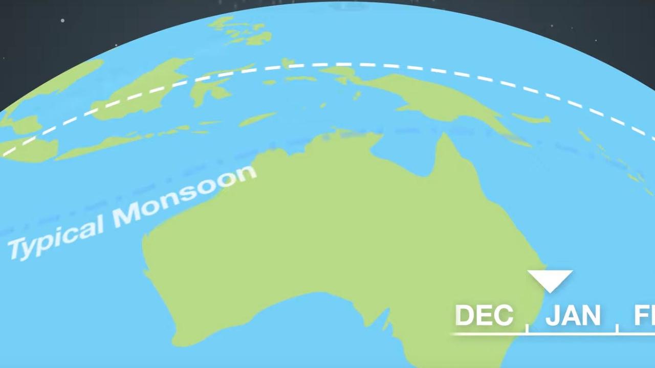
The IOD shouldn’t be here at all though. It’s like the party guest that won’t get the hint.
It usually appears in May. The monsoon that waters Northern Australia acts like a climate bouncer, turfing out the IOD around November before it can cause too much trouble.
However, the monsoon was late leaving India meaning the IOD is still ruining everyone’s party by pushing hot, dry air our way.
WEATHER THINKS IT’S WINTER
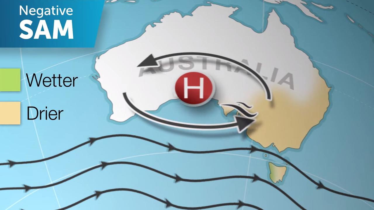
Then there’s the Southern Annular Mode (SAM) which is powered by Antarctic winds.
Usually it’s well down the pecking order of climate drivers. However, with the monsoon late and El Nino in neutral it’s like the Steven Bradbury of weather systems, winning at life.
In summer it helps push westerly winds towards the south of Australia.
In winter it heads north allowing those westerlies to travel across the continent from west to east.
The problem is, the SAM still thinks its winter. Just ask Tasmanians that are shivering due to the westerlies.
It’s a different story further north, where these westerlies are bringing all that hot, dry air cooked up by the IOD towards the east. It’s helping to fuel fires to Sydney’s west and then it picks up all that smoke and dumps much of it on the populated east coast.
“The reason we are having these strong winds is the Antarctic vortex which is a temporary anomaly on the typical pattern,” Sky News Weather Channel meteorologist Tom Saunders told news.com.au.
ONE THING THAT WILL REALLY HELP
A simple change in wind direction, or the overpowering of the bushfires in and around the Blue Mountains, would bring immediate relief to Sydney.
However, the trend is for winds to default to westerlies. So if a fire is west of the city, it’s likely Sydney will be engulfed by smoke from it.
The monsoon is on the horizon. Better late than never, and it is beginning to break down the IOD.
Nonetheless, the IOD’s effects could linger all December and the SAM could continue to funnel dry bushfire choked winds until January.
“As we move deeper into summer the less likely the chance of westerly winds will become,” said Mr Saunders.
However, as long as bushfires are raging, the wind – from whatever direction – will pick up the smoke and take it on a journey to somewhere else. And that could be towards Sydney.
The only sure fire thing to stop the acrid condition is rain. To dampen the fires and make the ash waterlogged enough it stops drifting.

The Bureau of Meteorology’s summer forecast predicts rainfall will slide back to average conditions across the centre of the nation and closer to average in South Australia and Victoria. It could even be wetter in parts of WA.
But not in the east, where not much is likely to improve. It’s is still looking very dry, with a 60 – 70 per cent chance moisture levels will continue to be far below average this summer.
So this week’s shower of charred leaves wafting over the inner suburbs, and drying clothes peppered with ash, might becoming a depressingly familiar sight.

Huge fire breaks out at UN climate summit

‘Political shortcuts’: Ley’s Labor ransom
