
‘Polar opposite’ change to Australia’s weather due
Spring is days away and that means a change of weather. But there’s an 80 per cent chance this spring could be very different to past years.


We are just days away from the official end of winter and weather watchers are saying that this year’s spring is likely to be very different to last year’s which led into one of the country’s worst-ever bushfire seasons.
In fact this year’s spring weather is likely to be the “polar opposite” of 2019.
It’s going to be cooler and a whole lot wetter. But only if you’re in the eastern two thirds of the continent; Western Australia has a very different outlook.
“Last year the bushfires really started towards the end of the spring. It was the driest spring on record and the fourth warmest based on 120 years’ worth of data,” Sky News Weather Senior Meteorologist Tom Saunders told news.com.au.
“It was so dry because there was a positive Indian Ocean Dipole. But now that’s been reversed so we have a negative Indian Ocean Dipole and we have a developing La Nina.
“It’s the polar opposite of what we had last year,” he said.
RELATED: Nino 3.4 – Pacific Ocean patch that could change Australia’s weather
Both the Indian Ocean Dipole (IOD) and La Nina – the flip side to El Nino – are climate drivers. How these climate drivers act can have an influence on the weather for months.
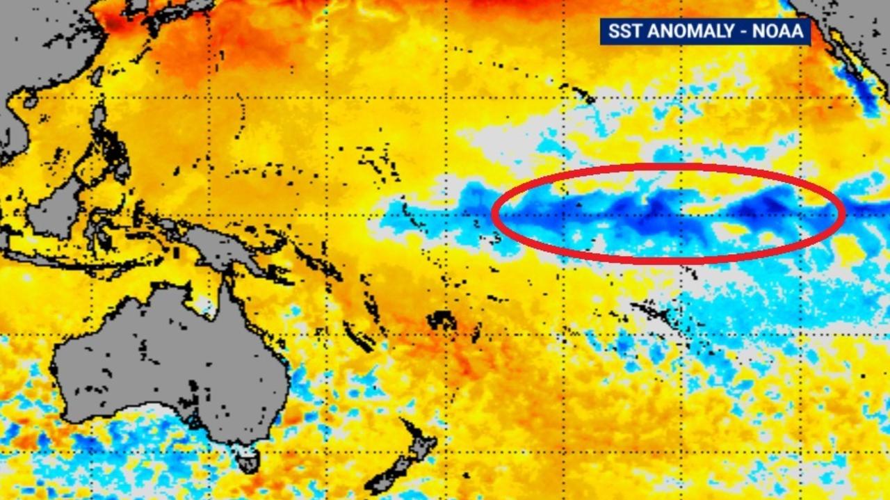
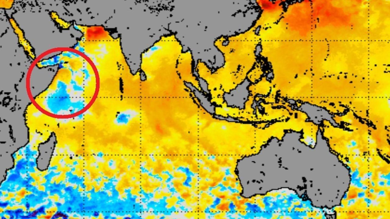
“Ocean temperatures around northern Australia are warmer than normal, while temperatures in the equatorial Pacific and off the Horn of Africa are colder than normal,” said Mr Saunders.
Cooler waters off Africa and in the centre of the Pacific – specifically in a patch of the ocean called Nino 3.4 – are big indicators of, respectively, a negative IOD and a La Nina.
“Winds tend to blow from colder oceans to warmer oceans is that’s pumping tropical moisture towards Australia.
“Also, warmer waters close to Australia increase evaporation and convection. In short, lots of moisture means more rain.”
WETTER WEATHER
Neither a negative IOD nor a La Nina has officially been declared yet. Nonetheless, they’re both very much on the cards and even without having cranked up into full gear, they are having an effect in pushing moisture Australia’s way.
For instance New South Wales, which was 100 per cent in drought in January, is now only 40 per cent in drought conditions. Parts of NSW have already seen flooding in the last few weeks.
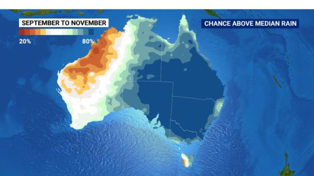
According to the Bureau of Meteorology’s seasonal climate outlook there is now an 80 per cent chance of higher than average rainfall across a huge area of Australia including almost the entirety of New South Wales, most of Queensland, Victoria and South Australia and the eastern half of the Northern Territory.
That is both good and bad news.
It’s good news for water storages with some dams near Sydney already near 100 per cent. It should also mean that dams in northern NSW, that have been at far lower levels, top up.
Farmers too can look forward to their crops getting a good soaking. But the big danger is if the rain just won’t stop and all the good work is undone. Too much rain leads to flooding or crops suffocated in mud which will ruin them.
COOLER DAYS
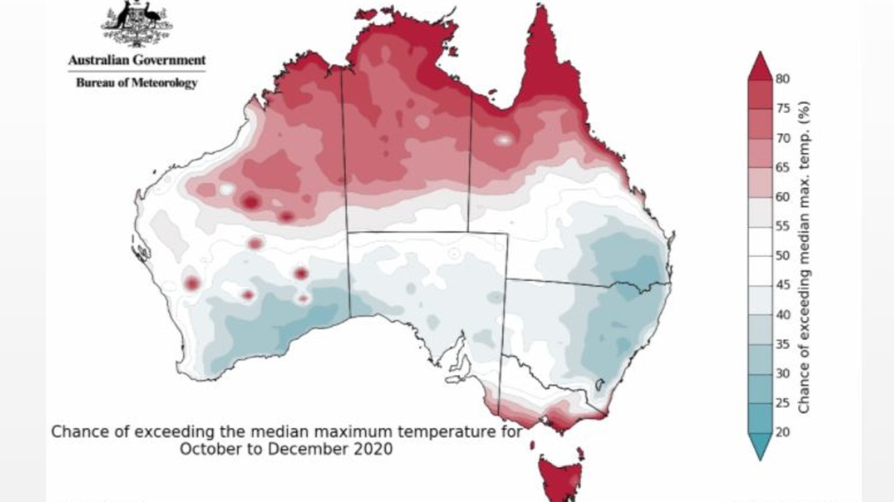
Heavier and widespread rain is also forecast to have an effect on how hot it gets.
“More clouds blot out the sun so that can often mean daytime temperatures are cooler than normal,” said Mr Saunders.
“However, night times can be warmer because the cloud acts like a blanket trapping in heat from the daytime.”
PLACES THAT WILL MISS OUT
There are always some exceptions and during spring tropical Australia, Tasmania and potentially coastal Victoria could actually see warmer days.
And when it comes to the increased rainfall, well pretty much all of Western Australia can count itself out of any unprecedented precipitation.
Most long term forecasts suggest much of the moisture will come to screeching halt somewhere in the middle of the Nullarbor, depriving areas west of extra rain.
Perth and populated southern WA will have an average spring. In the northern portion of the state – for places like Broome and Port Hedland – there’s a very good chance it will be drier than usual for October onwards.
But for most of us spring 2020 will be a wetter season than we’ve seen in some time with cooler days and warmer nights. Keep the brolley handy and don’t pack away the jumpers just yet.
benedict.brook@news.com.au


