
NSW weather updates: New evacuation orders, roads closed as Sydney floods worsen
The deadly weather system battering Australia’s east coast is now hurtling towards a new target, as rescue teams reveal fresh evacuation complications.

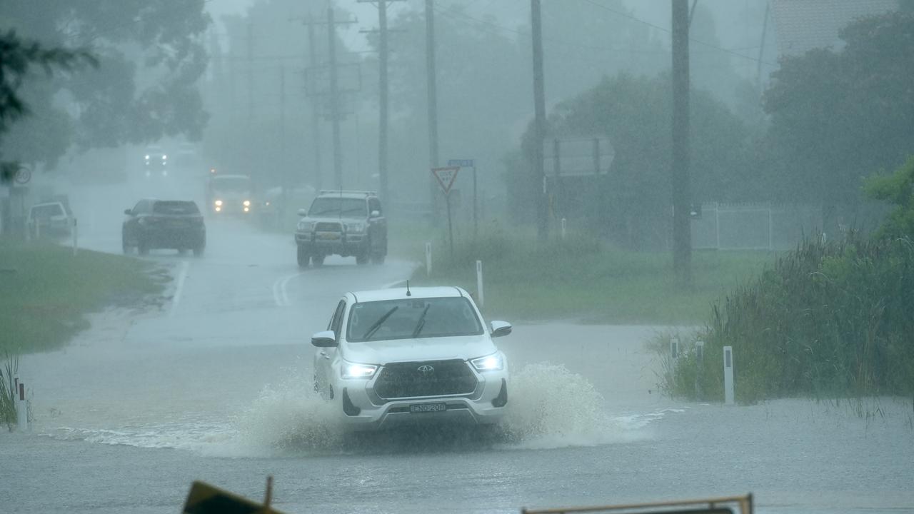
NSW residents have been warned to prepare for another day of potentially life-threatening flooding, as a destructive weather system continues to move its way down Australia’s east coast.
Thousands of residents have been urged to evacuate, with a severe weather warning in place from the Mid-North Coast to the south coast.
Hundreds of schools are expected to remain closed today as the torrential rain continues to batter the east coast.
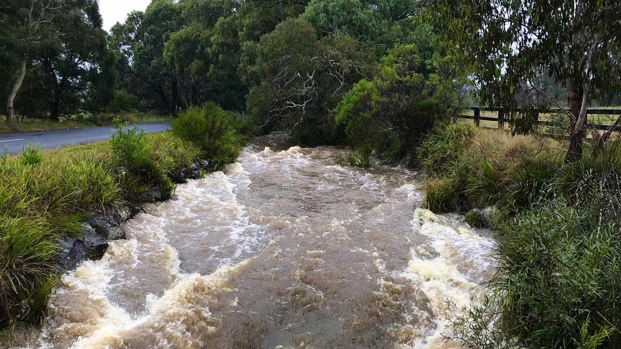
Overnight, the Hawkesbury, Nepean and Georges rivers continued rising at a rapid rate sparking a string of urgent evacuation orders across Sydney’s southwest and west.
The true impacts of the unprecedented weather event are now being uncovered in northern NSW as flood waters slowly recede.
At least four people have been confirmed dead as a result of the NSW floods, with recording artist, country singer and Lismore “local legend” Marge Graham named among the victims.
Follow our live coverage of the situation below. Make sure to regularly refresh the page for the latest updates.
‘Disaster’: Massive problem with evacuations
The Covid-19 virus is adding a whole other layer of complications as rescue crews rush to evacuate people across NSW.
Fire and Rescue NSW commissioner Paul Baxter said it has been a challenge to keep everyone safe in evacuation centres with the threat of Covid still present.
“One of the really difficult things to manage was taking people into evacuation centres then people putting their hands up and going ‘I’ve also got Covid’,” he told reporters in Lismore today.
“It’s just these extra dimensions that are just making things so complicated and difficult to manage, but those local people, the local service crews, the community members are helping their people.”
He added: “This is a big disaster and it’s over such a widespread area.”
Deadly storm sets sights on new target
The east coast low that has been deepening off NSW has begun to hit Newcastle and the Central Coast, bringing torrential rain and possible thunderstorms.
Six hourly rainfall totals between 60mm-100mm are possible, along with damaging wind gusts of more than 90km/h.
Local intense rainfalls exceeding 200mm are also possible.
The system will begin to weaken this evening, meaning parts of Sydney could avoid the worst of the downpour.
However, BOM forecaster Olenka Duma said Sydneysiders were still at risk from flash flooding from surrounding widespread rainfall.
“It wont push all the way down to Sydney but there will certainly be more widespread rainfall in the next few hours and potential thunderstorm development,” she told The Daily Telegraph.
“Everything is still quite saturated so the flash flooding in the Hawkesbury and western parts of Sydney will continue.”
‘Get ready’: 500,000 impacted by evacuations
NSW Premier Dominic Perrottet has said there are at least 500,000 people across the state currently impacted by either an evacuation order or warning.
“We have currently half a million people across our state who are subject to either one of those warnings or one of those orders,” he said on Thursday morning.
“If you are subject to one of those evacuation warnings, please get ready.”

Mr Perrottet said authorities expect the floods will be “worse than they were last year”, particularly in the Hawkesbury region.
Minister for Emergency Services Steph Cooke urged people to continue to listen to the warnings and leave the area if they are told to evacuate.
She said Sydney, the Central Coast and Hunter regions are “bracing themselves for treacherous weather conditions today”.
However, she assured residents that support would continue to be provided to people in northern NSW who are still reeling from the impacts of the floods.
Evacuation orders increasing
The NSW SES has issued a string of new evacuation orders, with the ongoing rain causing rivers to rise rapidly.
People in the Bents Basin area of Wallacia have been ordered to “evacuate now”.
All those in properties along Bents Basin Road must proceed along Bents Basin Road to Silverdale Road and then head to Wallacia or Silverdale.
Once floodwater reaches nine metres at the Wallacia Weir the area will be isolated and residents may become trapped without power.
People in low lying properties in Maclean must also evacuate if they can. If it is not safe to evacuate then residents should get to high ground.
The impacted areas include Argyle Street, Bakers Lane, Bank Lane, Basin Street, Cameron Street, Centenary Drive, Central Avenue, Church Street, Clyde Street, Diamond Street, Dunoon Crescent, Dwartes Lane, Emerald Street, Houghs Lane, Howard Street, Lona Close, John Street, Jubilee Street, McLachlan Street, McNaughton Place, Morven Street, Rannoch Avenue, River Street, Rush Lane, Sapphire Close, Stanley Close, Taloumbi Street and Union Street.
Flooding forces road closures
The Pacific Highway is closed both directions from Glenugie to West Ballina between River St and Big River Way due to flooding.
The Illawarra Highway is closed at Macquarie Pass, with people being urged to avoid the area.
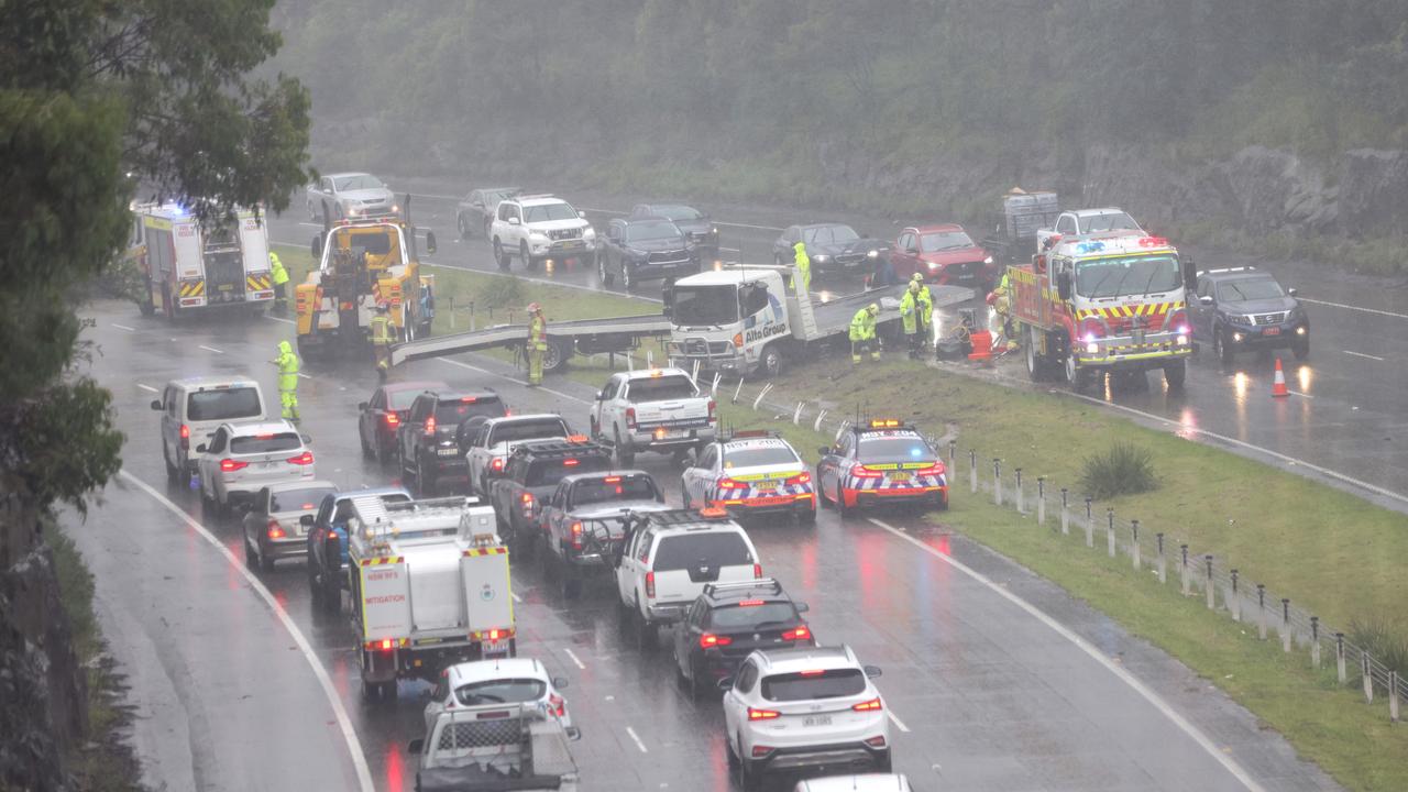
Windsor’s Bridge street is closed between Macquarie St and Wilberforce St, with the bridge closed in both directions. North Richmond and Yarramundi bridges are also closed.
Newbridge Rd remains closed between Henry Lawson Dr and Governor Macquarie Dr at Chipping Norton.
Henry Lawson Dr is also closed in both directions between Newbridge Rd and Hume Hwy from Milperra to Lansdowne.
CHIPPINGTON NORTON: Newbridge Rd remains closed btwn Henry Lawson Dr and Governor Macquarie Dr due to flooding. Avoid the area and use an alternative route. pic.twitter.com/TZLicQkEiD
— Live Traffic Sydney (@LiveTrafficSyd) March 2, 2022
Fears people could be trapped for days
With flood levels rising so rapidly, there are concerns that people who don’t get out in time could become trapped in waterlogged areas for days.
Penrith Mayor Tricia Hitchen told the ABC she was worried about what will happen to people in her community.
“I’m concerned about what will happen today. My greatest concern is how fast the water is flowing in the river,” she said.
“If people don’t leave now, they may be caught there for a couple of days until the water subsides. That’s our greatest concern at the moment.”
More than 100mm of rain is expected to fall on Penrith today, with residents being urged to keep an eye on evacuation orders from the SES.
Stranded family rescued from roof
Dramatic footage has emerged showing a family of five being rescued from the roof of a home in NSW’s Northern Rivers.
The video, from Life Flight, shows the family huddled together on the roof of a home surrounded by muddy flood waters.
One by one they are hoisted up onto the helicopter to safety.
A LifeFlight chopper reached a family of five stranded by floodwaters near Ballina, as severe flooding continjes to grip the NSW Northern Rivers #nswfloods (🎥: LifeFlight) pic.twitter.com/7GRkwKCgGN
— Declan Bowring (@DeclanBowring) March 2, 2022
More evacuation orders across Sydney
The SES has issued a series of new evacuation orders across Sydney, as more homes become threatened by rising floodwaters.
People in the following areas have been ordered to leave by 9am today:
North Richmond area: All properties in Patya Pl and 38 to 54A and 53-55 Keda Cres.
Vineyard area: All properties along Latona Ave, Old Hawkesbury Rd, Chapman Rd (from Killarney Chain of Ponds to Windsor Rd) and 417 to 633 Windsor Rd.
Londonderry area: Low-lying parts of the area should proceed to Northern Rd and south towards Penrith.
Mulgrave area: All properties between South Creek, west of the Windsor Rd, the railway line and to the north of Park Rd.
Riverstone area: All properties in West Parade, Carlton St, Trevithick St, Creek St, Denmark Rd, Pacer St, Garfield Rd West between Bells Creek and the railway line, Garfield Rd East between Eastern Creek and the railway line and Richards Ave.
Shane Park area: Properties along Shanes Park Rd from Whites Rd to the causeway just north along Shanes Park Rd. Properties in Shanes Park along Whites Rd and along South Creek Rd near Whites Road.
South Maroota area: 274 Pacific Park Road and all properties on Devin Grove within Pacific Park Water Ski Gardens.
Cattai area: All properties in the western part of Cattai along Threkheld Dr.
Northern part of Yarramundi: Area bounded by the Grose River, Hawkesbury River and Mahons Creek, including properties along Springwood Road, River Road and Mountain Ave.
#EvacuationOrders have been issued for parts of: Cattai, North Richmond, South Maroota, Yarramundi, Windsor, Shanes Park, Riverstone, Londonderry, Holsworthy, East Hills, Pleasure Point, Vineyard, Sandy Point, Picnic Point, Tuggerah Lake â—ï¸
— NSW SES (@NSWSES) March 2, 2022
Full details: https://t.co/BCnxAe6tsRpic.twitter.com/OTwccAVK5i
Next 24 hours ‘critical’ for NSW
NSW residents have been warned to “prepare for the worst” as torrential rain, flash flooding and possible thunderstorms continue to wreak havoc in parts of the state.
Emergency Services Minister Steph Cooke said the weather system is continuing to move south, making the next 24 hours “absolutely critical” for the state.
“Sydney is copping a battering … That will continue for some time,” she said.
“All of our attention is on Warragamba Dam.
Ms Cooke added authorities were expecting to see “something similar” to the March 2021 floods that destroyed thousands of homes across NSW.
Major Flooding is occurring in southwest Sydney exceeding March 2021 levels with Major Flood warnings in place. It's raining, with some areas hit harder than others and more rain on its way. Keep a serious eye on the warnings and forecasts: https://t.co/2qM1QRn3xE@NSWSESpic.twitter.com/37j66m7iHA
— Bureau of Meteorology, New South Wales (@BOM_NSW) March 2, 2022
A severe weather warning is in place for people in the Hunter, Metropolitan and Illawarra regions, along with parts of the Mid North Coast, south coast, Central Tablelands, Southern Tablelands, South West Slopes and Snowy Mountains.
Six-hourly rainfall totals between 80-120mm are likely for these areas. More than 200mm over six hours is also possible as a result of locally intense rainfall and thunderstorms.
Damaging wind with peak gusts of 90km/h may develop over parts of the coastal fringe on Thursday morning.
Hundreds of schools closed today
Hundreds of schools across NSW will remain closed today amid rising flood waters and wild weather.
At least 207 public schools and 47 independent schools will be non-operational across the state today.
A full list of school closures can be found here.
The closures come as deepening Tasman Sea low-pressure system continues its way towards the NSW coast.
There was 86mm of rainfall recorded in the six hours to 3.45pm at Warragamba yesterday, with another 73mm recorded to 9.45pm.
In Picton, 82.5mm of rain fell in the six hours to 6.15pm and Wanganderry saw 78.2mm in the six hours to 4pm.
Situation going to ‘get worse’
Residents are bracing for another day of evacuations, with Deputy Premier Paul Toole warning the situation was deteriorating.
“This is our worst fear. We are seeing the situation get worse. And it will get worse before it gets better,” he said on Wednesday.
“If you were affected by floods in March of 2021, then you are asked to leave your home now.
“This is going to be a tough night for residents in that area. This is going to be a tough night for people here in NSW.”
SES Commissioner Carlene York said the rainfall was unprecedented.
“I also must caution you that this is an intense rainfall and we have seen record levels that we haven’t seen in the recorded history,” she said.
“So even though your street may not be mentioned in some of these alerts, just be aware that the waters may rise in other areas and be alert and be prepared.”
Ms York said “quite a few hundred thousand people” would be affected by the alerts sent out tonight, including nine locations subject to evacuation warnings.

‘Salacious’: Barnaby fires up on leadership
Barnaby Joyce says his campaign to end the commitment to net zero has nothing to do with trying to push out Nationals leader David Littleproud.

Millions of Aussies set for soaking
Lashings of rain and destructive winds are on the way for the majority of Australia, with more wet weather on the way.

‘Never seen before’: Shock pics of algal bloom
A federal minister has spoken out about the dead marine life from a toxic algal bloom as new pictures reveal the extent of the devastation.