
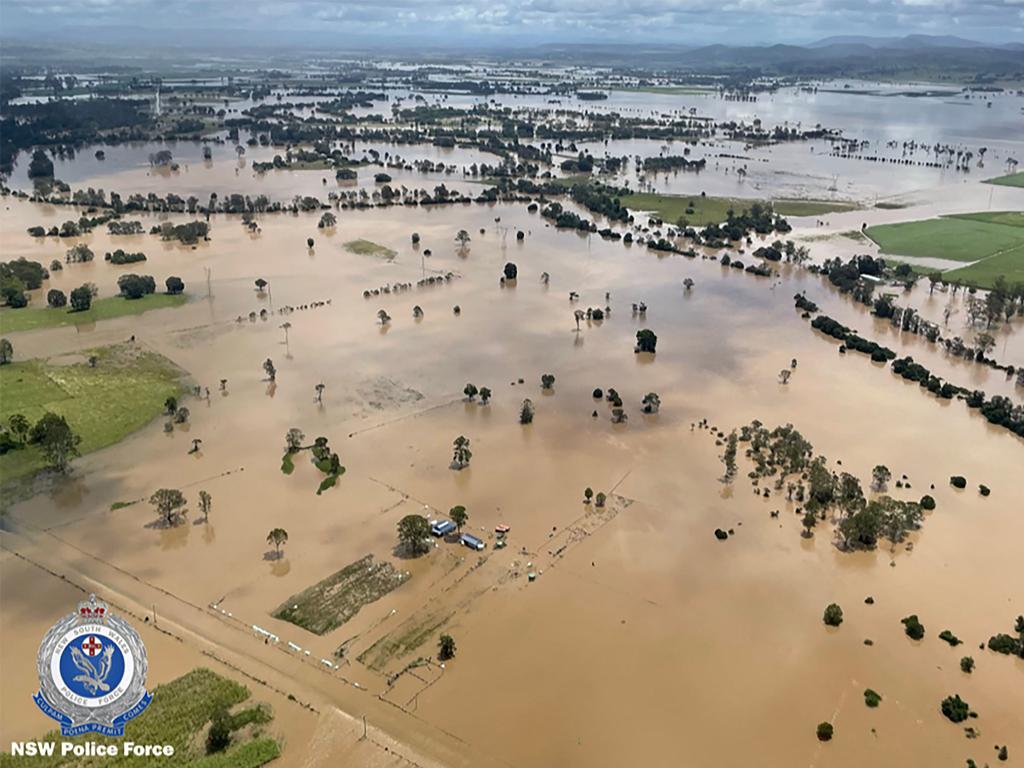
NSW evacuation orders issued by SES
More evacuation orders have been issued as a deadly weather system sweeps down Australia’s coast. Here is the complete list.
Even more locations in NSW have been issued evacuation orders while a further nine spots have been given warnings to leave.
Here is a list of the current warnings in place as of Thursday morning:
Evacuate these areas by 9am:
Southwest Sydney:
- Parts of East Hills: Henry Lawson Drive along service road opposite Maclaurin Avenue
- Parts of Picnic Point: Carinya Road
- Parts of Holsworthy: Heathcote Road, between Harris Creek and Deadmans Creek
- Parts of Sandy Point: St George Crescent
- Parts of Pleasure Point: Northern side of Riverview Road
Sydney’s northwest:
- Parts of North Richmond: all properties in Patya Place, North Richmond. 38 to 54A and 53-55 Keda Crescent, North Richmond.
- Eastern parts of Vineyard: All properties along Latona Avenue, Old Hawkesbury Road, Chapman Road (from Killarney Chain of Ponds to Windsor Road), 417 to 633 Windsor Road.
- Low lying parts of Londonderry: Proceed to Northern Road and then south towards Penrith.
- Parts of Mulgrave: All properties within the area of all properties between South Creek, west of the Windsor Road, the railway line and to the north of Park Rd.
- Parts of Riverstone: All properties in the following streets in Riverstone: West Parade, Carlton Street, Trevithick Street, Creek Street, Denmark Road, Pacer Street, Garfield Road West between Bells Creek and the railway line, Garfield Road East between Eastern Creek and the railway line and Richards Avenue
- Parts of Shane Park in Sydney’s west : Properties along Shanes Park Road from Whites Road to the causeway just north along Shanes Park Road. Properties in Shanes Park along Whites Rd and along South Creek Road near Whites Road.
- Parts of South Maroota in Sydney’s north-west: All properties in the following streets in South Maroota: 274 Pacific Park Road All dwellings on Devin Grove within Pacific Park Water Ski Gardens.
- Parts of Cattai: All properties in the western part of Cattai along Threkheld Drive
Evacuate these areas by 10am:
Tuggerah Lake at Long Jetty:
- Berkeley Vale
- Chittaway Bay
- Chittaway Point
- Long Jetty
- Tacoma
- Tacoma South
- The Entrance North
- South Tacoma Road
- McDonagh Street
- Pollock Avenue
- Wolseley Avenue
- Panonia Road
- Wyong Aged Care Facility
- Low lying areas around the Wyong Racecourse and the Kooindah Waters Golf Course
- Low lying areas along Allison Road, Old Maitland Road, Yarramalong, Collies Lane, McPherson Road, Gavenlock Road, Mike Jennings Road and River Road
- Gavenlock Road area Pacific Highway
NSW SES: “No need to panic but you need to move away from the lake by 7am due to predicted rising floodwaters.”
Multiple warnings were also put in place on Wednesday evening, including many suburbs in Sydney’s southwest.
The warnings issued by NSW Police and NSW SES on Wednesday evening:
Evacuate immediately:
Camden:
- Sheathers Lane
- Kirkham Lane
- Menangle Road near Racecourse Road may be isolated
- Poplar Caravan Park
- Cawder Road between Barsden Street and Murray Street.
- Peter Avenue between Onslow Avenue and Belgenny Avenue
Parts of Leets Vale:
- Properties along River Road from Douglas Creek in the part of Leets Vale on the southern side of the Hawkesbury River.
Low lying part of Freemans Reach:
- Properties in the lower part of Freemans Reach along Freemans Reach Road from Wilberforce Road to Hibberts Lane, along Hibberts Lane Freemans Reach Road to the first bend northwards, along the lower part of Argyle Reach Road
- Properties in the southern part of Wilberforce along Wilberforce Road from Windsor Bridge to Buttsworth Creek.
North of Bligh Park:
- Properties between Bligh Park and South Windsor along Berger Road and Fairey Road between the Sewerage Treatment plant at the southern end and Penruddock Street at the northern end.
Parts of Sackville:
- All properties in the following streets in Sackville:562 to 624B and 555 to 715 Tizzana Road.
Parts of Cattai:
- 177 O’Briens Road
- 161 O’Briens Road
- 87 to 97 Cheesmans Road
- 70 Cheesmans Road
- All residents in Riverside Caravan Park in Cattai. Evacuation route here.
Parts of Agnes Banks:
- All properties in low lying parts of Agnes Banks along Springwood Road from the Yarramundi Bridge to Price Lane, and including Price Lane.
Another one for 11pm
Parts of Ebenezer:
- All properties along Hendrens Road and 114-136 and 113-161 Ebenezers Wharf Road.
- All properties on Coromandel Road bordering the Hawkesbury River.
Georges Hall
Parts of Chipping Norton:
- Southern side of Newbridge Road, between Davey Robinson Drive and Miperra Bridge
- Northern side of Newbridge Road between Rickard Road and Riverside Road.
- Eastern side of Henry Lawson Drive, between Milperra Road and Auld Avenue.
- Epsom Road between Westbury Street and Governor Macquarie Drive.
- Riverside Road between Newbridge Road and Alfred Road
Parts of Lansvale:
- Knight Street between Day Street and Hollywood Drive
- Lower Day Street
- Erna Avenue
- Lucy Avenue
- Mena Avenue
- Willis Street
- Hollywood Drive Between Knight Street and Willis Street
Parts of Milperra:
- Auld Avenue
- Deepwater Park
- Eastern side of Henry Lawson Drive between Milperra Road and Keys Parade, Webster Street, Maxwell Avenue.
Parts of Warwick Farm:
- The Warwick Farm Racecourse
Parts of Moorebank:
- Western side of Epsom Road, Between Westbury Street and Childs Road
List of locations ordered to evacuate
• Redbank Dam
• Ballina Island
• Low Lying areas of: Western Lennox Head, Ballina CBD, South Ballina, Ballina
• Wardell
• Low lying parts of: Wharf St, Casino, Casino near river, Lawrence and surrounding areas
• Tweed Heads
• East Bellingen
• Low lying properties in Maclean
• Low lying areas Broadwater and Cabbage Tree Island
• Woodburn, Swan Bay and Surrounds
• Clarence River at Brushgrove and Cowper
• Low lying properties in: Southgate, Ulmarra
• Murwillumbah CBD and low-lying areas of East Murwi and Coraki
• Rocky Creek Dam
• Brunswick River at Mullumbimby
• Marshalls Creek at Billinudgel
• Ocean Shore, New Brighton, Sth Golden Beach
• Low lying properties in Iluka
• Lismore CBD, North Lismore and South Lismore
• Sth Murwillumbah, Condong, and surrounding areas
• Kyogle Lower CBD
• Tumbulgum and Surrounding Areas
Locations under “evacuation warning”
• Picton CBD
• Camberwarra Dam
• Parts of Lansvale
• Parts of Milperra
• Parts of Chipping Norton 1
• Parts of Chipping Norton 2
• Northern Rivers
• Sth Murwillumbah, Condong, and surrounding areas
• Uki and surrounding areas
Source: NSW SES via NSW Police
Read related topics:Weather
Join the conversation

‘Big’: Wild weather warning to Aussies
Aussies in several states have been warned to brace for a weekend of wild weather, with the risk of floods and damaging winds.
Read more

Aussie miner drops F-bomb 10 times in rant
An Australian miner’s expletive-laden rant about the future of coal-burning has caught the attention of the world’s richest man.
Read more

Aussie city’s coldest morning in 15 years
An Australian capital city has recorded its coldest morning in more than a decade, with temperatures close to freezing.
Read more