
Severe thunderstorms strike Sydney with damaging wind, hailstones and lightning strikes
UPDATED: A severe thunderstorm swept through large parts of the Sydney area, with large hailstones and damaging winds leaving thousands without power.

LARGE hailstones, heavy rain and damaging winds struck New South Wales on Tuesday evening, with severe thunderstorms leaving thousands without power.
More than 10,000 homes across the state have been left without power, according to The Daily Telegraph.
Power providers estimate about 11,000 homes and businesses lost power across the NSW Southern Highlands, the Illawarra and Sydney due to the extreme storm conditions, The Telegraph said.
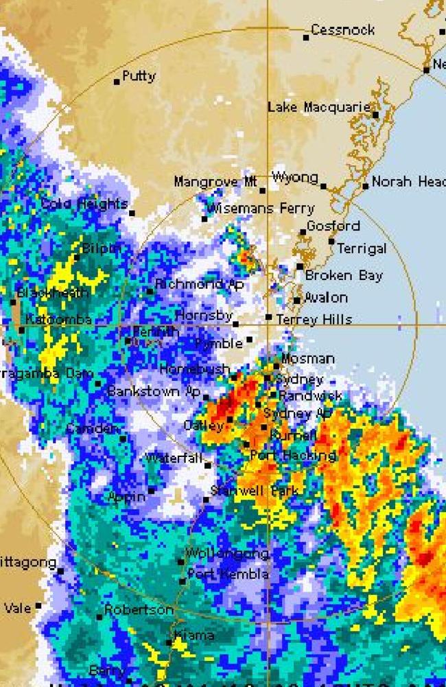
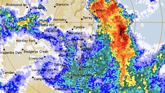
“The Bureau of Meteorology warns severe thunderstorms were detected on the weather radar near Sutherland, Liverpool and Glenorie. These thunderstorms are moving towards the east to northeast. They are forecast to affect Hornsby, Parramatta, Sydney City, Sydney Airport, Sydney Olympic Park, the Sydney Harbour Bridge, Mona Vale and waters off Bondi Beach by 7:40pm and Calga, Gosford and Woy Woy by 8:10pm,” the warning read.
“Damaging winds and heavy rainfall that may lead to flash flooding and large hailstones are likely.”
Storms hit Greater Wollongong, the Blue Mountains and the Hawkesbury region.
Winds of up to 98km/h have been recorded at Parkes.
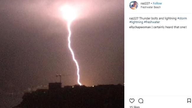
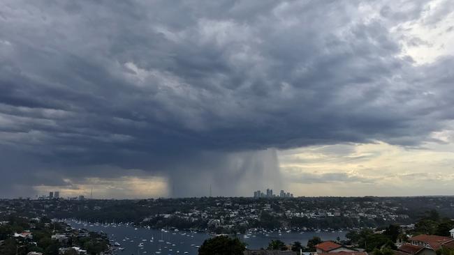
The State Emergency Service was on high alert as heavy rain swamped the city and lightning strikes were recorded in the eastern suburbs.
A Coogee resident told news.com.au “lightning was hammering us from all directions”.
“It was just so loud and intense.”
The only thing I miss about Sydney: the epic summer storms. RT @edenlola: What a sight! Never witness rolling clouds like this before. #sydney #storm pic.twitter.com/D3fELVQnpW
— Katie Hale (@katie18O) January 9, 2018
Massive #shelfcloud ploughs along the #Sydney coast #storm #weather pic @nampix for @smh pic.twitter.com/IwR2gl2WtQ
— Nick Moir (@nampix) January 9, 2018
Cloud front rolls into Manly. Pic by @splitenzus #aussiesummer #storm #SydneyStorm #Sydney pic.twitter.com/dNedaZ4FD3
— Georgina Swan ðŸ³ï¸â€ðŸŒˆ (@swandives) January 9, 2018
Wow what a storm! Can’t get over the sky though now! #innerwest #sydney #storm #sky pic.twitter.com/EOdimHo0tx
— ☆KeeKs Adventure☆ (@KeeKss927) January 9, 2018
NSW SES has received 270 jobs since 10am, 70 in Metro. Most jobs for minor damage such as leaking roofs and fallen trees and branches. Storms in Sydney have now passed. Call 132500 for emergency help.
— NSW SES (@NSWSES) January 9, 2018
It was the second time today thunderstorms have caused havoc in Sydney. Sydneysiders were rudely woken from their slumber at 4am today as a deafening thunderstorm ripped through the city.
One user on social media site Reddit summed it up: “The first massive crack of thunder was literally the loudest I have heard in my life. I physically jumped in the air, and my heart is still pounding.”
But meteorologists have scoffed at the storm’s strength saying it “wasn’t even severe”. And they’ve warned a far more dangerous super cell storm could be lurking in its wake.
Canberra residents have been warned to buckle down as a storm bringing 100km/h winds heads to the city at around 4pm on Tuesday.
Meanwhile, in Western Australia, the Bureau of Meteorology (BoM) has said there is now a “significant risk” of a cyclone forming over the coming days.
More than 4600 lightning strikes hit Sydney early this morning with electricity providers working to restore power to thousands of homes.
The storm came less than 48 hours after the city was struck by one of its hottest days ever with a high of 47C being recorded in parts of the city.
Sky News Weather’s Samantha Chiari told news.com.au that Penrith, in Sydney’s west, recorded 11mm of rain in just 10 minutes at 4am as the skies opened up.
Almost 18mm of rain has fallen in Sydney’s CBD with 35mm being dumped on Holsworthy in the city’s southwest.
Sydney Trains reported delays to rush-hour services following lightning damage to equipment while the State Emergency Service received more than 150 calls for help.
“There’s currently a low pressure trough above Sydney and because it’s been so hot it’s an unstable environment and that’s what has caused the storm,” Chiari said.
When it came to storms, however, the early morning wake-up call was nothing much to write home about, she said.
“The storm that impacted Sydney wasn’t even that severe. Rather, it’s the timing that woke everyone up.”
But there could be something worse bubbling up behind.
“There is the potential for a super cell storm this afternoon or evening and that could bring heavy rain and damaging winds,” Ms Chiari said.
Super cells are caused when wind shear reaches high levels leading the storms to rotate. These storms can be violent and are often accompanied by strong winds and hail. However conditions can change quickly which could see the super cell fail to develop.
At 2.30pm on Tuesday the BoM issued a severe thunderstorm warning for much of southern and Central West NSW and the ACT and said storms were “possible” across almost the entire state.
Gusts of almost 100km/h could hit Canberra on Tuesday afternoon.
“A trough moving through the state with warm and high humidity air ahead is bringing storms to the state today,” the Bureau stated. “The strong storm movement and fast winds aloft mean damaging wind gusts are the likely phenomena.”
On Tuesday, Sydney should see a high of 31C and up to 20mm of rain. In the city’s west, the mercury could reach as high as 37C.
Cooler conditions in NSW had been forecast for this afternoon but Chiari said that might now be delayed.
“The cool change is coming through but later than initially forecast. It’s looking more like the evening around 6pm or 7pm.”
In the Kimberley region of Western Australia, a tropical low is building up strength that could see it become a tropical cyclone.
The low has made landfall and is currently tracking towards Derby and Broome.
The BoM said the low is bringing sustained winds with gusts of up to 85km/h. It should move off land on Tuesday but could well come back in a different form.
“The low is expected to strengthen over open water and may become a tropical cyclone on Wednesday or Thursday,” the BoM said.
Tropical Cyclone Watch remains in place for coastal areas between Kuri Bay and Wallal Downs, including Broome. Significant risk of a severe tropical cyclone impacting northern WA. https://t.co/B1MVXBYXhh pic.twitter.com/S0HcmMY5aY
— Bureau of Meteorology, Western Australia (@BOM_WA) January 8, 2018
“There is a significant risk of a severe tropical cyclone impacting northern WA later in the week.”
Elsewhere conditions are calmer. Melbourne will have a sunny day and a high of 22C rising to 34C by Thursday. It’s set to be a balmy 32C in Brisbane while Darwin will be 33C and stormy.
Further south, Adelaide will reach 26C on a sunny day with a high of 35C on Thursday. Hobart will be 22C with possible showers while Perth will reach 35C.
- with The Daily Telegraph

What Labor’s green reforms won’t fix

Influencer blasted for illegal act on island
