
Heat to persist in Sydney until late Tuesday
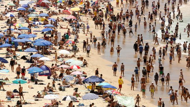
SYDNEY was the hottest place in the world on Sunday and the city will continue to sweat today. But relief is in sight, say forecasters.

IF YOU thought the punishing weather in Sydney was over — guess again.
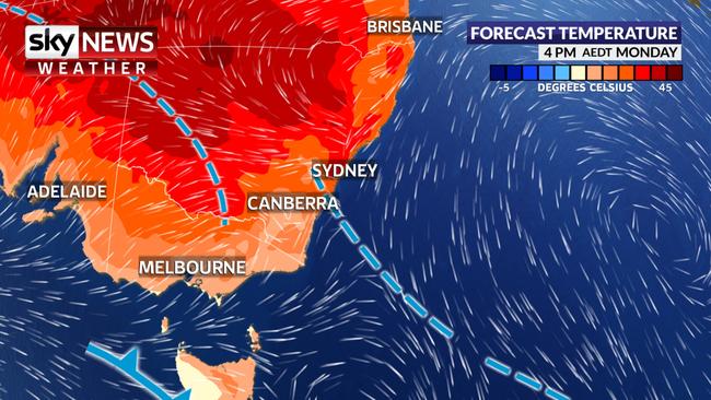
On Monday, parts of Australia’s largest city will once again roast in unseasonably hot conditions with temperatures north of 40C forecast for Sydney’s west.
Heat wise, it’s also set to be an above average day in other capitals including Perth.
But relief is in sight, meteorologists have said, with late Tuesday the point when all of Sydney is likely to see a sustained cooler change roll through.
On Sunday, Sydney took out the title as the hottest place on earth with the city as a whole recording its highest temperatures for 79 years.
Sky News meteorologist Tristan Meyers said it was the residents of Penrith, in the western suburbs, which topped the temperature table, peaking at 47.3C just after 2.30pm.
“Individually, Newcastle, Wollongong, Gosford and Sydney (CBD) all had their hottest days in five years; Canberra had their hottest day in four years while on Saturday, Melbourne, Adelaide and Hobart had their hottest days in two years,” he told news.com.au.
“Today, it looks hot again, with temperatures reaching 40C+ in central and western suburbs of Sydney, and the mid-to-high 30s in the CBD.
“This is because although we had a gusty southerly overnight, it was weak and therefore north-westerly winds — hot, dry winds from the interior — have developed yet again,” Mr Meyers said.
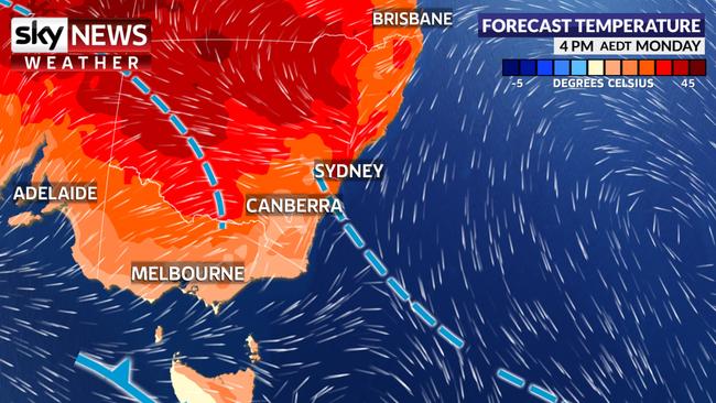
Monday in Sydney’s CBD will peak at 33C with possible showers. However, inland Sydneysiders aren’t so lucky with a high of 41C for Richmond and 42C for Penrith.
Further north, inland areas close to Newcastle will also sweat buckets with Maitland reaching 43C.
Away from NSW, temperatures will be less severe on Monday. However, Canberra, Perth and some Brisbane suburbs will see the gauge streak past average levels.
On Monday, the NSW Rural Fire Service (RFS) issued a total fire ban for the entirety of Sydney and the Newcastle and Hunter regions.
RFS spokesman James Morris warned the public that a cooling of conditions in parts of Sydney didn’t mean the danger was over.
Monday’s forecasted winds and rainfall won’t penetrate too far west, he said.
“That’s accompanied by winds which may push up around the 40km/h mark, so firefighters are on standby to respond to anything should it kick off,” Mr Morris told ABC Radio on Monday.
A total fire ban is once again in place for the #Sydney and #Hunter areas today. Hot and windy conditions are forecast. Review your fire plan this morning and know what you will do in the event that your home or property is threatened by fire today. #NSWRFS pic.twitter.com/FyGo73r53p
— NSW RFS (@NSWRFS) January 7, 2018
“We’ve seen over the past month fires that we’ve had, haven’t necessarily been burning on days of ‘severe or above-fire-danger’ rating ... the fuel is dry out there, the fuel’s dry all around NSW.”
Mr Meyers added: “It will be hot again tomorrow, but there will be a thundery cool change rolling through NSW on Tuesday and into Wednesday, looking to hit Sydney late afternoon [on] Tuesday.”
Indeed Wednesday’s forecast high of 25C in Sydney would be below average for January. Temperatures will rise towards the weekend but are likely to stay in the 20s.
In the city’s west, a high of 37C on Tuesday will sink to 29C by Wednesday.
Storms could be in store across a broad area of NSW from Tuesday affecting Sydney, the Illawarra, the Hunter and Central Coast, the ACT and much of central and western NSW, Mr Meyers said.
“Otherwise we are watching the development of a low pressure system over the north of the country for the third cyclone of the season forming around Wednesday or Thursday impacting Broome and much of the Kimberley.”
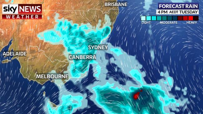
The CBD and coastal areas will enjoy some relief on Monday with temperatures in the low 30s, some rain and even a possible storm. Wednesday will be the coolest day at 25C but the 30s, let alone the 40s, will be a distant memory after Tuesday.
It will be hotter in the west with 42C on Monday but Wednesday’s 29C is only a brief respite. By Thursday it will be back up to 36C, but another trip to the 40s is off the cards this week. Possible storms.
Queensland’s capital will bob around the 31C mark all week with sunny conditions. Head inland and the temperatures head up with Ipswich reaching 34C and then 35C towards the weekend.
A stormy and sweaty 30-32C is in store for the Top End this week.
A hot and sunny few days in the west with 34C on Monday rising to 35C on Tuesday. In contrast, Thursday may only reach 24C but 37C is predicted for the weekend.
27C on Monday in Adelaide and it’s hotting up as the week goes on reaching 35C on Thursday. Sunny with some cloud.
A mild start to the week in Melbourne with 22C on Monday but the heat will slowly creep in. On Thursday expect 34C during a mostly dry week.
Tassie’s capital will see 25C on Monday with the possibility of a shower. The hottest day is set to be Thursday with a high of 29C.
The capital will continue to be toasty on Monday with a high of 33C and a possible shower. A stormy Tuesday will reach 30C with the likelihood of a storm. Friday will be the warmest day at 34C.

‘Never seen before’: Shock pics of algal bloom
A federal minister has spoken out about the dead marine life from a toxic algal bloom as new pictures reveal the extent of the devastation.

Albo reconnects with Aussie icon in China
Anthony Albanese has gotten a big dose of panda diplomacy in China, reconnecting with an Aussie favourite as he winds down his state visit.

Greens demand PM act on toxic bloom
As one Aussie state continues to suffer from a “disaster” algae bloom that is putting the future of the fisheries industry in crisis, the Greens have made a simple demand from Albo.