
Fresh tropical cyclone warning for parts of Western Australia
A fresh warning has been issued for residents in one Aussie state, as a possible cyclone continues to make its way to the coast.

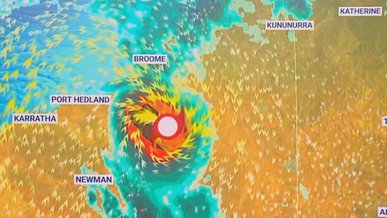
Western Australian is bearing down in preparation for a cyclone that could have a “severe impact” on coastal areas later this week.
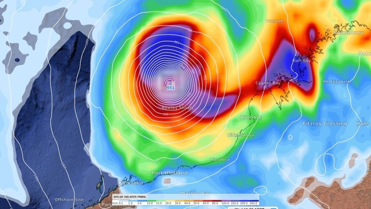
Cyclone Ilsa, currently about 430 kilometres northeast of Broome, in the Kimberly region, has been likened to Cyclone Rusty which hit just east of Port Hedland in 2013.
Rusty broke records with sustained gales for 39 hours straight and brought extensive flooding, causing almost $800 million of economic loss.
The Bureau of Meteorology (BOM) has forecast Cyclone Ilsa could reach category four strength as it swerves and heads towards land, south of Broome, late Thursday or early Friday.
Authorities on Monday issued warnings for people living in or visiting coastal areas between Broome and Port Hedland, telling everyone to prepare for dangerous conditions or leave.
Cyclone Ilsa is forecast to be a category four system when it crosses the coast and is expected to be downgraded to a category three at some time Friday morning.
The CTCX chooses violence
— Sausiuswx (@Sausius_wx) April 9, 2023
(and yes if this verified, it would be the strongest cyclone in the basin since reliable records began)#cyclone#18S#tropicswxpic.twitter.com/0mZS6Wf1LW
Once-in-a-decade storm
“There is no excuse for not being prepared. It is going to be a severe tropical cyclone, certainly a category three and the potential to be higher than that,” Department of Fire and Emergency Services Commissioner Darren Klemm said.
“It’s been some 10 years since there’s been a cyclone greater than category three through this area.
“Everybody from Broome through to Port Hedland need to make sure they’re enacting their plan. Now’s the time to be cleaning up around home, make sure you’ve got an emergency kit and make sure you’re keeping up to date with the various warnings coming out”.
Gales with wind gusts to 90 km/h and heavy rainfall may develop between Cape Leveque and north of Broome on Wednesday as the system passes to the north while intensifying, the BOM has stated.
A blue alert – which asks that preparations be made for dangerous weather – is in place for people in or near Cape Leveque to Broome, not including people in the town of Broome itself.
Tropical low continues to develop slowly; may reach tropical cyclone strength overnight. Severe coastal impact likely late in the week. https://t.co/B1MVXBHUfhpic.twitter.com/4XCpGD6kBz
— Bureau of Meteorology, Western Australia (@BOM_WA) April 10, 2023
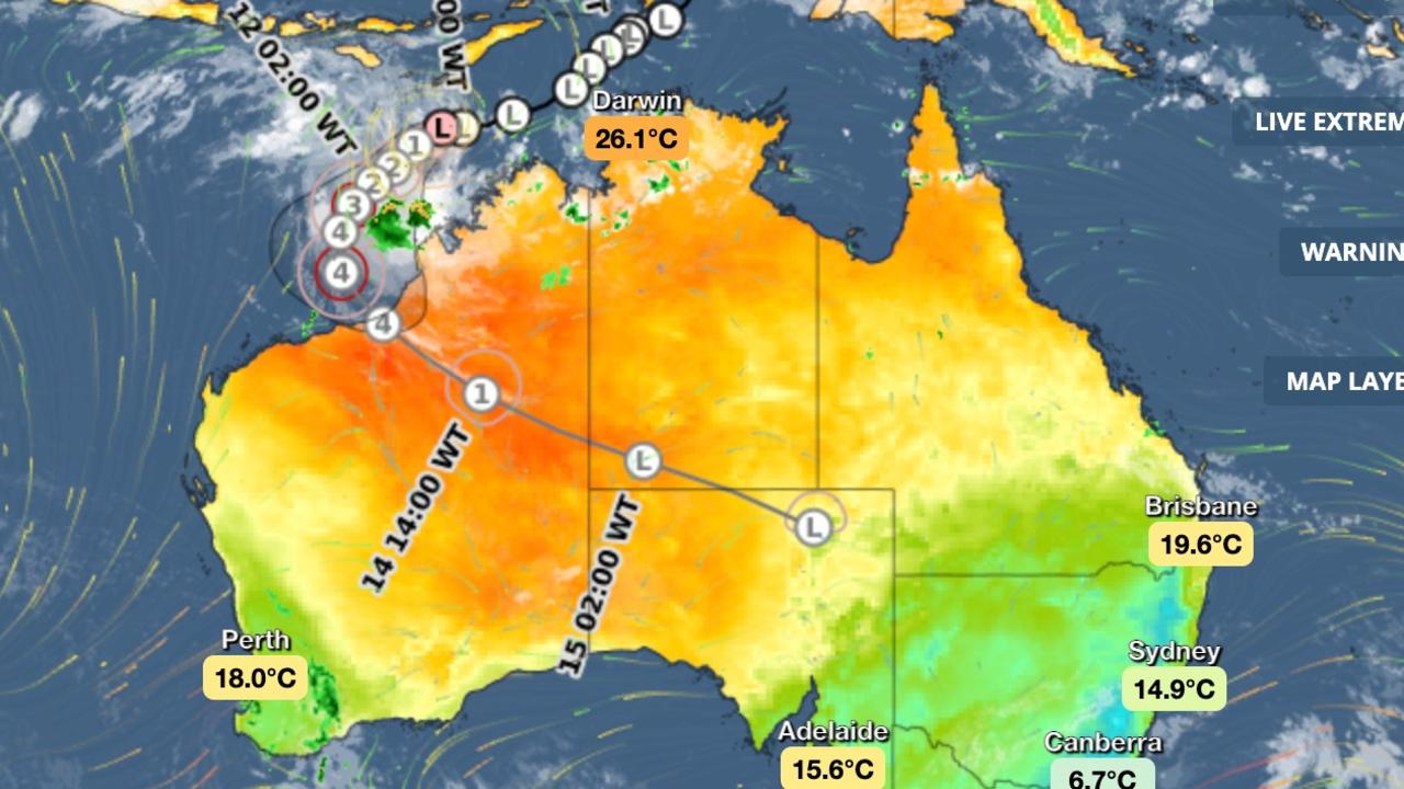
“We are expecting the system to continue to track to the southwest,” the BOM’s Western Australia and Northern Territory manager Todd Smith said.
“On Wednesday, it may take more of a southerly track and then even recurve towards the southeast as it approaches the coast later on Thursday.
“So we’re really urging residents in the west Kimberly and the east Pilbara to really pay attention to the warnings from the bureau and the advice from emergency services over the coming days as the system develops off the northwest shelf.”
“Depending on where that system crosses the coast, the impacts are likely to be destructive wind gusts near the centre of the system, we’ll see abnormally high tides and large waves in coastal areas, particularly to the east of where the system crosses the coast,” Mr Smith said.
“We’ll also see heavy rainfall that can lead to localised flash flooding.”
Up to 200mm could fall each day as the cyclone travelled inland along the De Grey catchment area, he added.
Residents have been warned of gales with wind gusts up to 90 km/h and heavy rainfall that could develop between Cape Leveque and north of Broome on Wednesday as the system passes to the north while intensifying
Squally thunderstorms with heavy falls are expected over the northern Kimberley throughout Monday and Tuesday.
Abnormally high tides were also possible along the Kimberley coast between Kalumburu and Kuri Bay Monday and Tuesday. In some locations, the tide could be close to the highest astronomical tide of the year.

Weekend ruined for millions with storm hell

Water turns green at popular Sydney beach
Tradies blamed for turning the water fluorescent green at one of Sydney’s most popular beaches.
