
El Nino climate driver has kicked in – Bureau of Meteorology
The Bureau of Meteorology has made a major call that signals there will be very warm and dry conditions over the summer.

The Bureau of Meteorology has officially announced that the El Nino climate driver has come into effect.
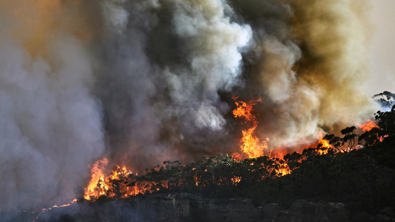
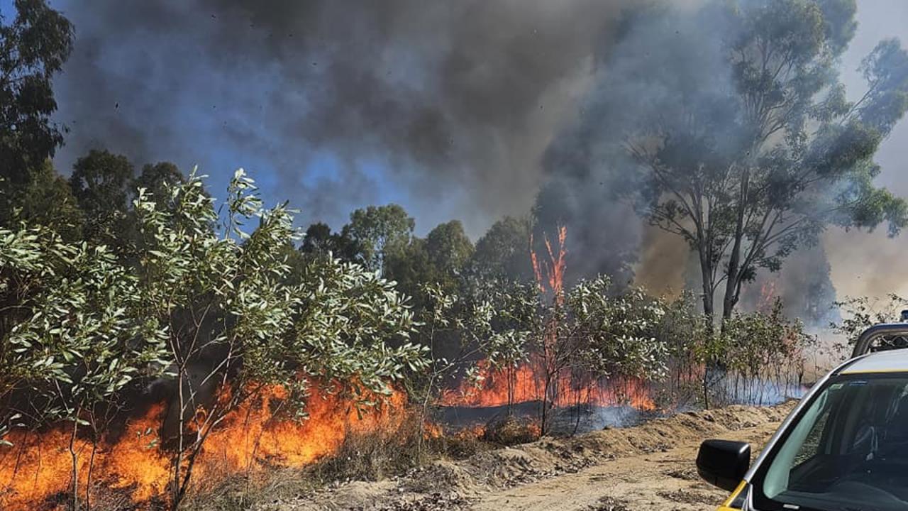
It comes amid soaring temperatures and extreme fire danger across parts of south-east Australia.
A meteorologist with the Bureau of Meteorology said now that the El Nino pattern is settling in, it increases the BoM’s confidence this pattern will last until the end of summer — meaning a continuation of warm and dry conditions.
“We are already seeing extreme conditions in some part of the continent, particularly in the duration of heat,” he said. “We’ve had an extended period of warm and dry weather to start spring, today we’ve had catastrophic conditions on the south coast of NSW just to underscore that risk.
“While we are different to leading into the black summer in 2019 where we had years of preceding drought, we do have a wetter landscape out there, it is drying out more rapidly than has occurred in recent years, and we are seeing that elevated risk now occurring in eastern NSW in particular and Sydney equalling its record so far today for temperatures for September.”
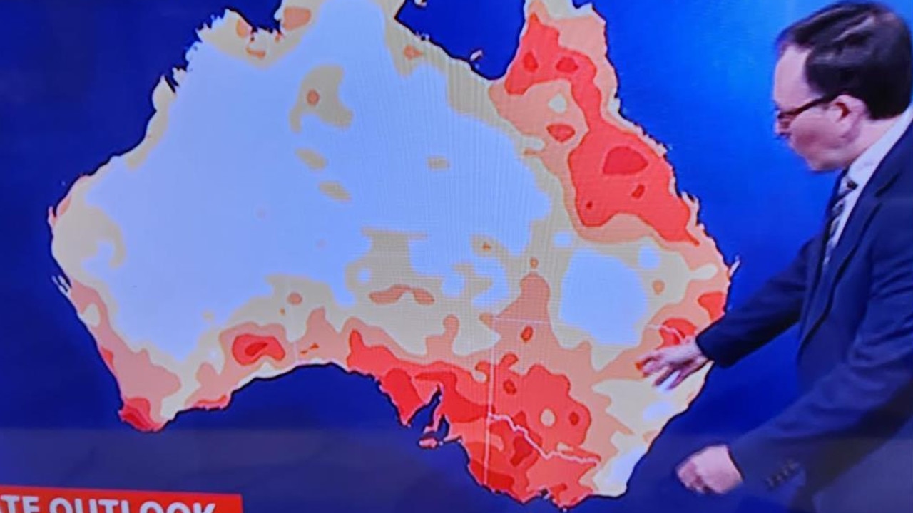
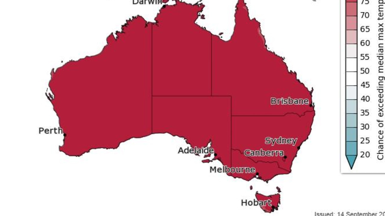
A map on the BoM’s website shows an over 80 per cent chance of the median maximum temperature being exceeded right across the nation from October to December of this year.
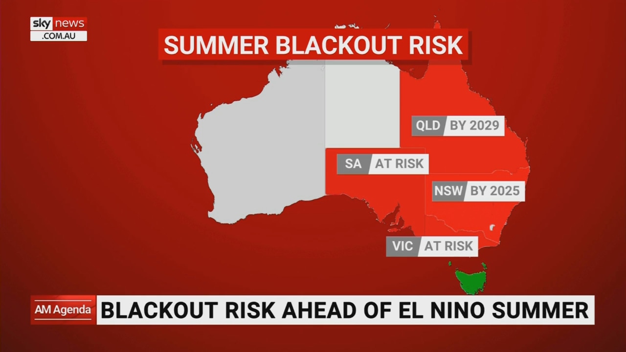
The Bureau of Meteorology meteorologist said NSW and Victoria was likely to be hit the hardest.
“I think El Niño means we’ve elevated the risk of fire danger and extreme heat, in particular in terms of the hazards we face … We aren’t leading into this summer on the back of extended drought, which somewhat reduces the risk, but we have seen eastern NSW dry out quite particularly,” he said.
“I think there’s 61 fires burning in the landscape in NSW at the moment and I think that just underscores if we continue to dry out the landscape over the next three months … then we’ll be adjusting our message accordingly in terms of the risk.”
He foreshadowed the continuation of global heat until the middle of 2024.
“We have had globally record warmth in the oceans since April and to give you an idea of the interplay between the two, we believe that that continued ocean warmth is potentially one of the things that slowed down the atmospheric response,” he said.
“This year we’ve had continued warm conditions everywhere, which is more to do with the background trends than it is to do with El Niño. El Niño tends to impact global temperatures from now until the middle of next year.”
Bureau of Meteorology’s Miriam Bradbury said such prolonged warm weather being experienced by NSW and Victoria had not been seen for several years.
Severe fire dangers were expected for the Greater Sydney and Hunter regions on Wednesday, she said.
“That is likely to trigger a total fire ban as well – it depends on the RFS’s decision there,” she said.
A cold front would sweep across Tasmania and Victoria onwards from Wednesday and push up the NSW coast through Wednesday and Thursday.
First however, Sydney would swelter through 34 degrees on Wednesday before cooling off.
BOM late to declare El Nino
The BOM is months behind other meteorological agencies globally in calling El Nino. This is due to the fact the Bureau has a higher bar of when El Nino has come into effect.
There are fears El Nino will lead to a scorching spring and summer for Australia with lower than average rainfall as moisture that would otherwise wash over eastern Australia instead is sucked further out into the Pacific Ocean.
And its effects could be super-sized by a combination with another climate driver to Australia’s west.
The last El Nino contributed to 2016 being the hottest year on record.
El Nino is one extreme of a Pacific Ocean climate driver called the El Nino Southern Oscillation, or ENSO. At the other end of ENSO is La Nina.
During El Nino, the temperature of a specific area of the central and eastern Pacific – called Nino 3.4 in meteorological circles – rises.
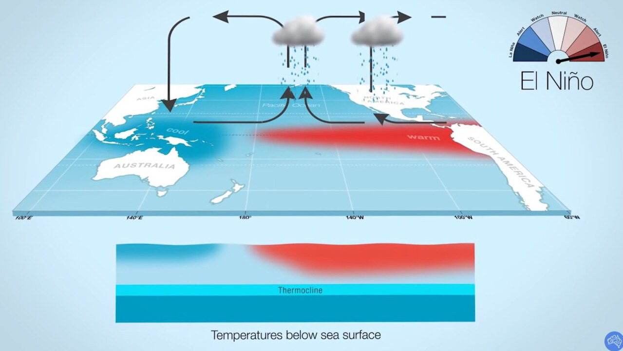
This aids in the creation of clouds and rainfall further into the Pacific.
That lack of rainfall over Australia can lead to drier conditions and drought for the country.
Conversely, when a La Nina takes over sea surface temperatures fall which ups the likelihood of rain closer to Australia.
And it’s not just El Nino, another climate drive is also causing a ruckus.
The Indian Ocean Dipole (IOD) refers to an index that measures sea surface temperatures in the tropical Indian Ocean.
A positive IOD would reduce the amount of moisture flowing towards Australia from the northwest which would also suppress rainfall and increase daytime temperatures.
The El Nino conditions are worrying meteorologists, fire fighters and farmers – all of who fear punishing conditions and stronger bushfires aided by lots of growth following a wet few years.
BOM’s late El Nino call
In July, United Nations’ World Meteorological Organisation (WMO) announced El Nino had kicked in. That came a month after the US’ National Oceanic and Atmospheric Administration (NOAA) said the same.
But while BOM has been on “El Nino alert” for some time, it hadn’t yet called it.
The disparity in calling El Nino is down to the fact that the BOM has a slightly different definition of the climate driver and is stricter when it comes to the level sea surface temperatures have to reach.
NOAA announces El Nino when sea surface temperatures at Nino 3.4 are 0.5C warmer than normal with conditions expected to last for another five months at least.
More Coverage

The BOM needs it to be hotter – as much as 0.8C. It also needs a number of other factors to kick in too.
The Bureau has consistently said that over the past few months sea surface temperatures had indeed risen high enough to exceed the El Nino threshold.
But until now, other observations such as wind, clouds and broad scale pressure patterns hadn’t occurred.

Reason housing crisis could get worse
Australians are already facing a shortfall of more than 640,000 affordable homes. There’s one reason that might get even worse.
Read more

Severe frost alert for Aussie farmers
Farmers are being urged to keep their livestock warm as a freezing start to winter puts animals at risk.
Read more

Aussie-first hydrogen servo opens
Australia’s first publicly accessible hydrogen service station has opened, in a huge move towards decarbonising commercial vehicles.
Read more