
Social media pokes fun at ‘dramatic’ Cyclone Jasper TV coverage
Cyclone Jasper has left 40,000 without power and a trail of destruction – but it hasn’t stopped social media mocking the “dramatic” TV coverage.
Social media users are poking fun at the “dramatic” Cyclone Jasper coverage by the major TV networks.
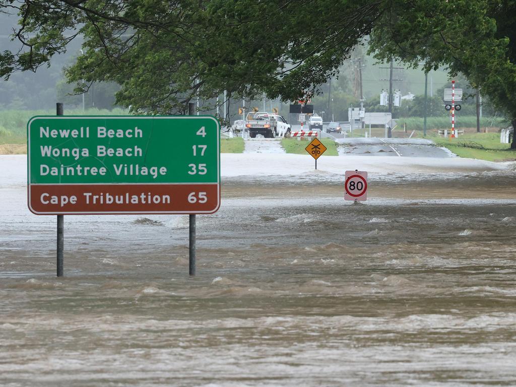
A clip of 7 News coastal expert Paul Burt drenched in rain reporting from Newell Beach north of Port Douglas on Wednesday went viral on TikTok.
“He’s more dramatic than the cyclone,” one person joked.
“When your life is falling apart but you still got to work,” another said.
Seven’s Sunrise turned off comments on Facebook after viewers mocked host Matt Shirvington’s tour of Port Douglas pointing out fallen trees.
“Surely now you can pull back on all the reports on this and just have basic updates,” one woman said.
And Nine’s Today also drew the ire of viewers. “Keep trying I’m sure it’ll be a record breaking storm eventually,” one Facebook user commented.
Another wrote, “I feel sorry for the reporters who are trying to make a fallen tree news.”
A parody by TikTok user @lifeofthecromies has gone viral.
The reaction on social media comes as Jasper was downgraded to a tropical low but it was a wild night and the cyclone continues to cause havoc.
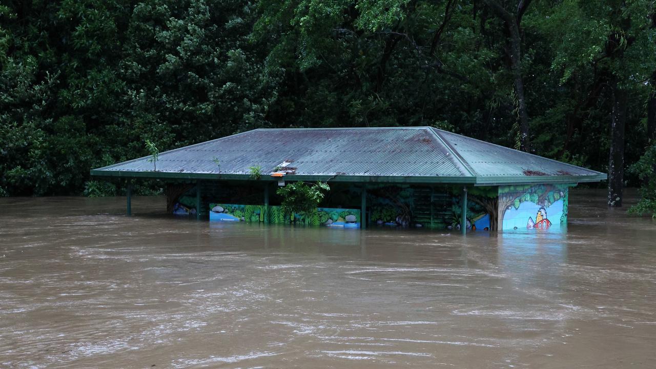
Emergency personnel rescued 18 people from dangerous flooding as Jasper brings heavy rain across far north Queensland, with 40,000 people still without power.
Authorities in far north Queensland say they are worried about a danger hour this morning.
Sky News weather meteorologist Bradlyn Oakes said flash flooding could come as soon as 9.30am on Thursday, when a high tide is expected, exacerbated by a storm surge.
“This could lead to large amounts of flooding especially when we have this storm surge,” she said.
âš ï¸ðŸŒ§ï¸Severe Weather Warning for Heavy to locally Intense Rainfall leading to life-threatening flash flooding for FNQ. Major flood warning current for the Daintree River and Flood Warning for the Mossman River. Damaging winds also possible. https://t.co/FBmpsInT9opic.twitter.com/DCSZGg0TeJ
— Bureau of Meteorology, Queensland (@BOM_Qld) December 13, 2023
“And 24-hour totals of rain could be up to half a metre. So we’re watching a large amount of wet weather that could cause life-threatening flash flooding.”
In Mossman, northwest of Port Douglas, 18 people have been rescued from a “dangerous localised flood” at Mossman River.
The SES was called to Mossman Street at about 1am this morning where eight people needed help, and crews then doorknocked and helped evacuate another 10 people, the ABC reports.
The 18 people were brought to safety in the local library.
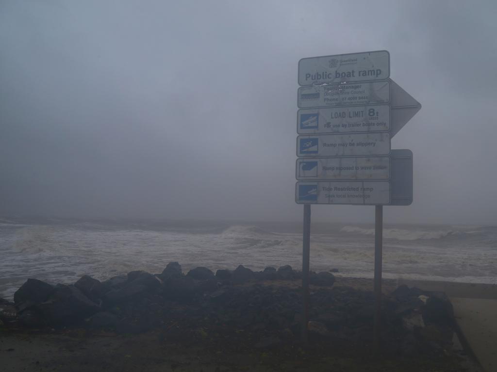
Storm surge
A storm surge is when coastal waters rise above the highest tide levels because of a cyclone. The tsunami-like waves can go some way inland.
Jasper made landfall at about 3pm on Wednesday, south of Wujal Wujal near Cape Tribulation. It remained at category 2 strength until about 9pm and is now, without the sea to feed it, an ex-tropical cyclone.
As of midnight the tropical low was centred 165km northwest of Cairns and 75km southwest of Cooktown.
“Ex-tropical cyclone Jasper is no longer of tropical cyclone intensity, however, impacts from heavy to intense rainfall and damaging wind gusts with showers and thunderstorms are still likely,” the Bureau of Meteorology (BOM) said.
Ex-tropical cyclone Jasper is no longer of tropical cyclone intensity; however, impacts from heavy rainfall and damaging wind gusts are still likely.
— Bureau of Meteorology, Australia (@BOM_au) December 13, 2023
A Severe Weather Warning is current for heavy to intense rain and damaging winds
Latest warnings https://t.co/Y9WTJQMu7Gpic.twitter.com/iw3YLUdyhh
“A severe weather warning and flood watches and warnings are current.”
In the early hours of Thursday morning, the BOM issued a severe weather warning covering more than a quarter of a million people from Cooktown to Cardwell including Cairns and Port Douglas and as far west as Dunbar encompassing Mareeba and Atherton.
The BOM has warned of torrential rain potentially leading to flash flooding along the affected coast with six hourly rainfall totals of up to 150mm being standard and pockets of 250mm. Isolated falls of up to 350mm in 24 hours are possible.
But between Cooktown and Cairns it could be particularly bad, the BOM has stated, with “dangerous and life threatening flash flooding”, as rivers swell due to up to 500mm of rain falling in some areas in a single day.
In at least one area, that’s already occurred.
Clarke Range, to the west of Mackay, received 467mm of rain in the 48 hours to 9am on Wednesday, before the cyclone officially hit. Cairns has seen 120mm up to 4am on Thursday.
The Low Isles off the coast of Port Douglas have seen 150mm over the same period.
There are also warnings of damaging winds gusts of around 90km/h along the coast, and extending inland to the Atherton Tablelands and as far as Palmerville and Chillagoe from late Thursday morning.
A major flood warning was issued for the Daintree river and a flood watch for the Mossman, with rainfall totals of up to 200mm recorded in both catchments in the 24 hours to 7pm on Wednesday.
“Heavy rainfall is forecast to continue overnight Wednesday and into Thursday,” the BOM said in its warning. Based on forecast rainfall, major flooding is possible from Thursday morning.”
A moderate flood warning was also issued for the Mulgrave River, and minor warnings for the Barron and Tully rivers.
Speaking alongside incoming Queensland Premier Steven Miles, a BOM spokesman described the event as an “evolving situation”.
“There’s also a risk of riverine flooding as well as storm surge as we see the high tide at 10am,” he said.
“In terms of riverine flooding, we’re still going to watch the current, with some warnings likely to be issued later today as we see more rainfall throughout the day.”
State Emergency Service (SES) had already responded to 80 calls for assistance, Mr Miles said.
Power out
As of Thursday morning about 41,000 Ergon customers are without electricity.
While Cairns CBD retains power, suburbs around the city, up to the Daintree and down to Tully are in the dark.
A spokesman from Ergon Energy Network said its crews had been told to take cover and wait until it was safe enough to assess the damage.
Damaging wind gusts of up to 120km/h were recorded along the south coast of Cooktown, including at Cairns, according to the BOM. Wind gusts of up to 140km/h are anticipated at Wujal Wujal and Port Douglas, where the cyclone landed.
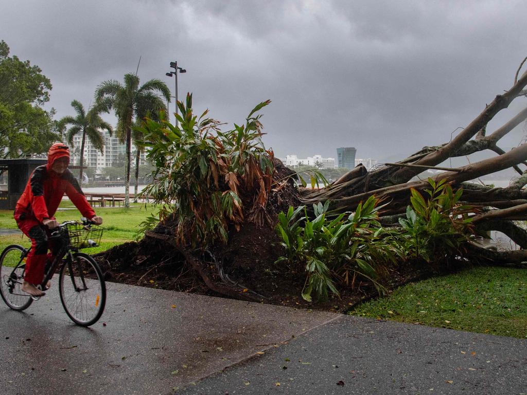
Incredible footage from Port Douglas showed torrential rain and ferocious winds battering the tourist town.
Trees whipped back and forth as branches fell. At Cairns, the tides flooded walkways by the ocean.
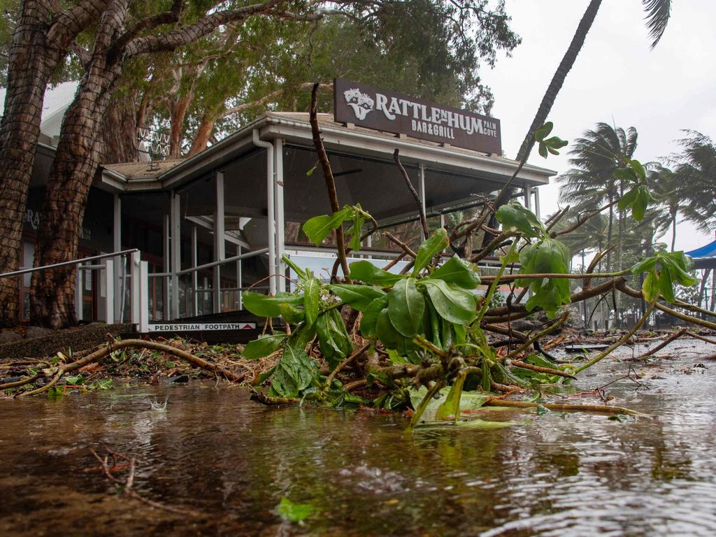
Other images taken at Port Douglas showed a massive tree knocked down in severe wind gusts.
The Australian Defence Force are poised to assist.
“We stand ready to support far north Queensland, the Queensland government and local governments in any way needed in the days ahead,” said federal Emergency Management Minister Murray Watt.
Cairns Hospital has reminded residents that medical assistance will be offered throughout the cyclone with the emergency department sandbagged as a precaution.
“We don’t expect the storm surges or the water to come over and affect the emergency department but cyclones are unpredictable so that is purely precautionary to protect the emergency department. We are open and ready to receive anyone we need to,” a spokesman said.
Storm tide shelters are open at the PCYC on Walker Rd and at Redlynch State College. These are only available to residents in red and orange zones.
More Coverage

Authorities are warning residents not to drive or walk through floodwaters due to the dangers they pose.
“We often think about the depth of the flood water or how fast the flood water is moving. But it’s what’s under the flood water that also proposes the rest of the community,” a Queensland Police spokesman said.
— with NCA NewsWire


