
Australia weather: Cold temperatures, rain expected over the weekend
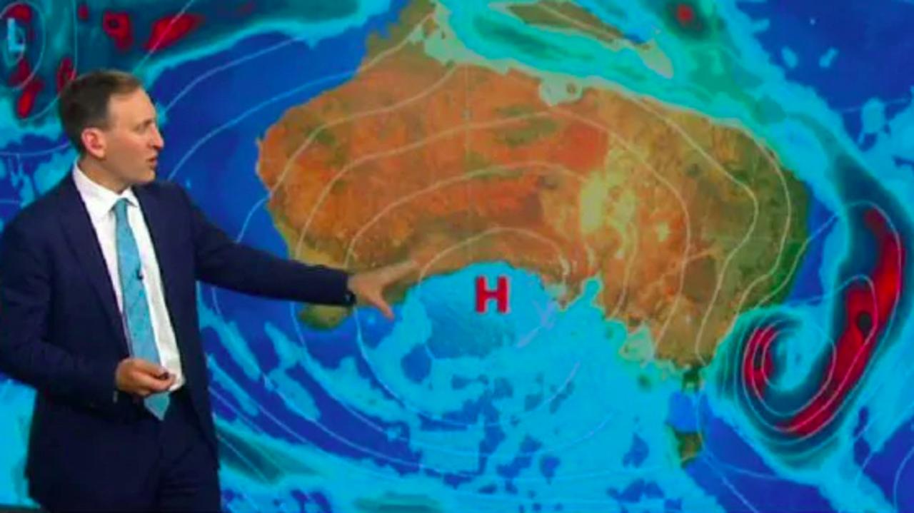
Multiple cold fronts will continue to blast Australia with wintry weather and widespread rain, after damaging winds and hail lashed overnight.

Victoria and South Australia bore the brunt of what’s forecast to be a week of wintry weather around the nation, with damaging hail, winds and rain lashing the states overnight.
A pair of cold fronts will set off a volatile mix of weather in parts of South Australia, Tasmania, Victoria, New South Wales, the ACT and Queensland, bringing blasts of heavy rain, thunderstorms and damaging winds in the coming days.
Sky Weather chief meteorologist Tom Saunders said the first front will move off the east coast today, with the second quickly following and causing another burst of showers – but not as many storms.
“Ahead of that front, there’ll be a band of rain spreading through southeast Queensland and northeast NSW and that will be attached to a northwest cloud band which is currently moving through Northern Australia,” he explained.
“This band of rain, it won’t bring severe weather, we’re not expecting damaging winds, but a burst of showers moving through southeast Australia.”
While temperatures ahead of the fronts are currently above average, they’re expected to drop below average as we move into Thursday, with the mercury dipping under 10C through the southern inland of NSW, parts of Victoria and Tasmania.
Pull out the gumboots, it's going to be a wet, wintry-like week for most of Australia ☔
— Bureau of Meteorology, Australia (@BOM_au) May 19, 2020
A series of cold fronts will impact the SE from today, while from mid-week a thick cloud band across #NorthernAustralia will bring rain & well-below-average temps 🥶 https://t.co/UFM6xiTsKo pic.twitter.com/0Y3jOaXdHb
At least four homes in western Victoria were left uninhabitable and up to 30 others were damaged by severe storms last night, as the first of the fronts moved in.
State Emergency Service assistant chief officer for the state’s south west region, Cain Trist, said the wind was so strong it blew roofs off houses, burst windows and tore down fences.
The SES received 130 calls for help around the Geelong area alone in the past 24 hours, and 222 across the state.
Meanwhile in Adelaide, the front brought heavy rain, damaging winds and hail to much of the city, with more expected later today.
LIGHTNING STRIKE - A 23y/o and his mum were cooking dinner when they heard a loud crack and started to smell smoke. Minutes later their home was engulfed in flame... CFS crews did all they could, but the entire contents of the house is destroyed. @9NewsAdel pic.twitter.com/iFgxEEbQyx
— Lucy Hinton (@LucyHinton_9) May 19, 2020
Moving into the weekend, rainfall will be heaviest on Thursday in NSW as the first front moves toward the east coast and decays, forming more of a trough tomorrow and bringing more unsettled weather to the eastern portions of the state.
A second area of rainfall, Mr Saunders explained, led to the forming of a Tasman low – and if it becomes an east coast low, “severe weather is possible”.
The south coast of NSW and eastern Victoria could be in store for “damaging winds, heavy rain and flash flooding” if that were to happen.
“Perhaps the most likely scenario is it’ll be just far enough off the coast that the strongest winds and the heaviest rain will be sitting just offshore.
“But we are expecting minimum, perhaps moderate rain, for eastern Victoria and the far south coast of NSW.”
A cold front to cross #Victoria overnight bringing a burst of rain and possibly a thunderstorm. A second cold front will cross the State from late Wednesday bringing more showers, snow on the Alps and much colder conditions. Check your latest forecast at https://t.co/z9VjgwqX6p pic.twitter.com/pi8kCqwY9Y
— Bureau of Meteorology, Victoria (@BOM_Vic) May 19, 2020
As the first front moves across from the southeast today, temperatures in Sydney will begin to dip, with a minimum of 9C and a maximum of 18C expected on Friday, along with a 60 per cent chance of rain.
Canberra will also be in for wintry weather ahead of the weekend, with a minimum of 1C and a maximum of only 13C on Friday.
In the Sunshine State, Brisbane will drop to a low of 11C on Saturday with a high of 19C, with rainfall expected in parts of the state from today.
Melbourne, already on track for its wettest autumn in nearly 50 years, will stay cold and wet tomorrow and Friday, with maximums of 14C and minimums of 7C.
Hobart will be similar with lows of 7C on Thursday and Friday and highs ranging from 13C to 15C.
Sunday will be Darwin’s coldest day, though still a relatively warm minimum of 19C and a high of 30C, with low chances of rainfall.
And in Perth, temperatures will dip early next week, with minimums of 9C and 7C on Monday and Tuesday after a wet end to the weekend.

‘300,000 deaths’: Japan’s horrific prediction
One of the world’s most populous nations has warned 300,000 of its residents could die in an ominous new prediction.
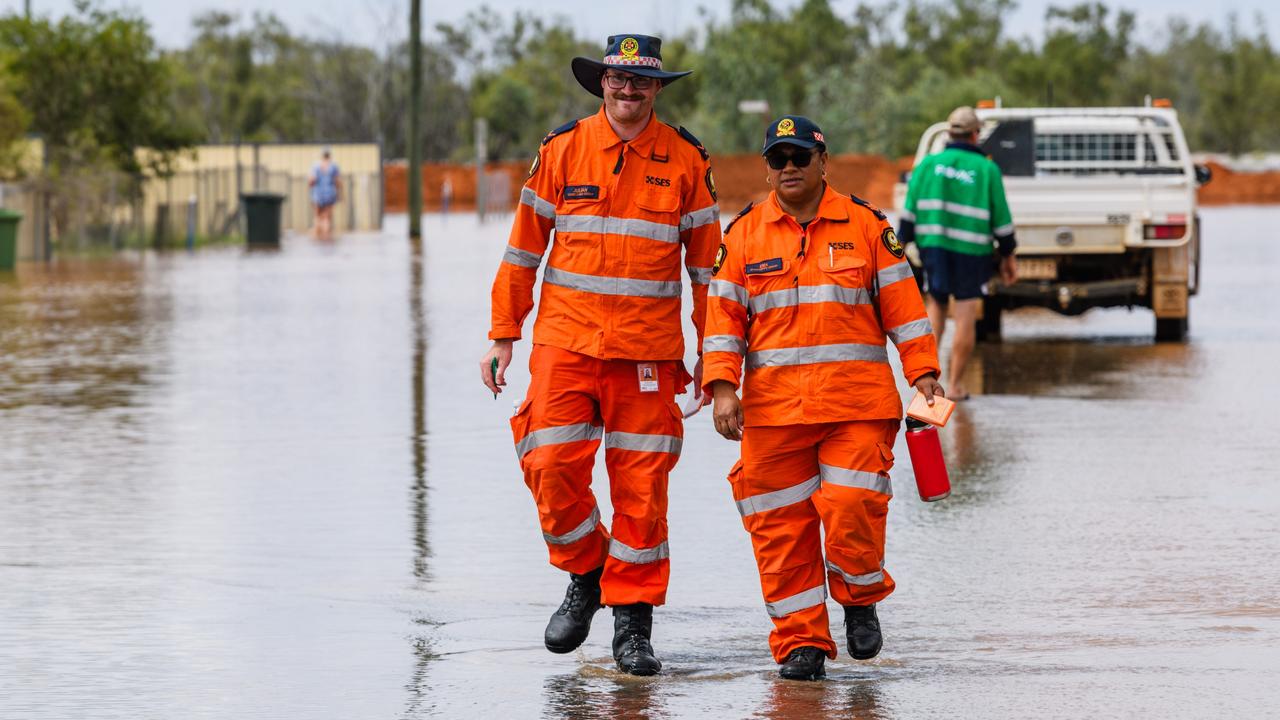
‘Copped it’: Flooded residents sleep in cars
Already isolated outback residents who are sleeping in their cars can expect more rain and flooding in the coming days.
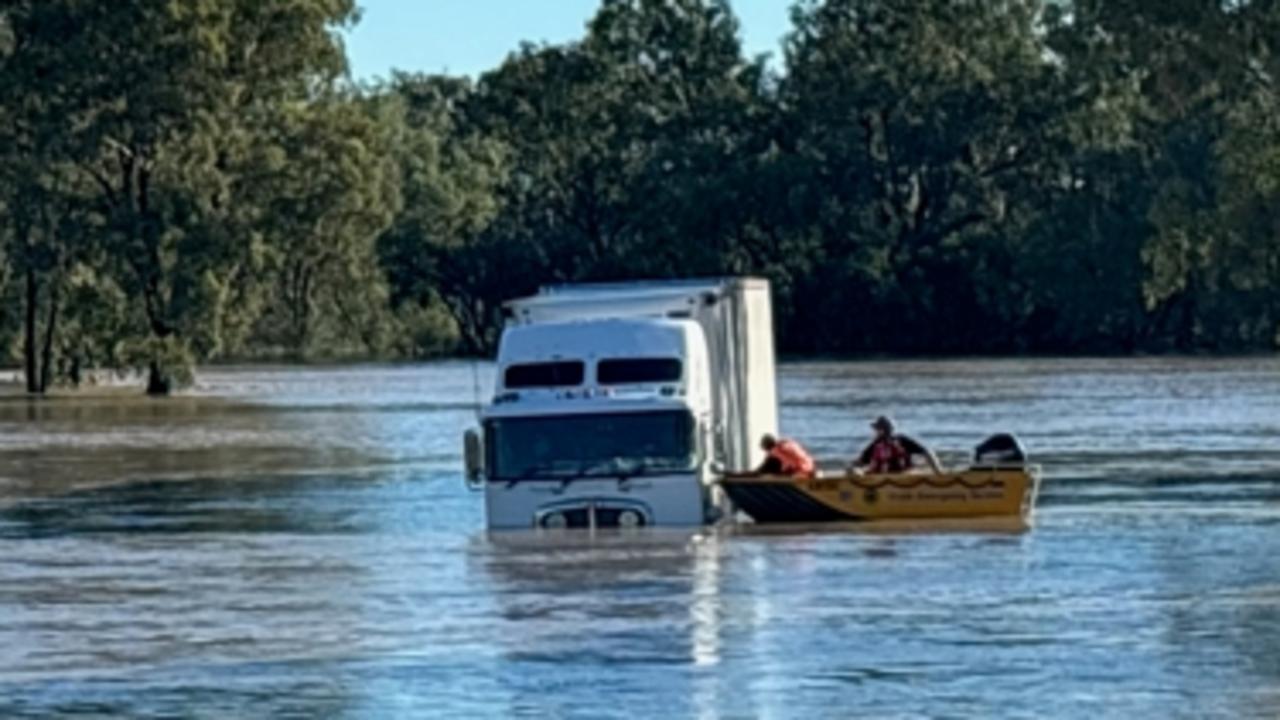
Truck driver rescued as floods smash Aussies
Incredible photos have captured the moment a truck driver was rescued from floodwaters, as severe weather smashes the country.