
Darwin weather: Top End at ‘moderate risk’ of tropical cyclone later this week, BOM confirms
The Bureau of Meteorology says the Top End is now at a moderate risk of being buffeted by a tropical cyclone later this week, most likely Friday. Here’s the latest from the big wet.


Tuesday, 3.30pm: The Bureau of Meteorology believes there is a “moderate risk” for a tropical cyclone forming over the Top End later this week.
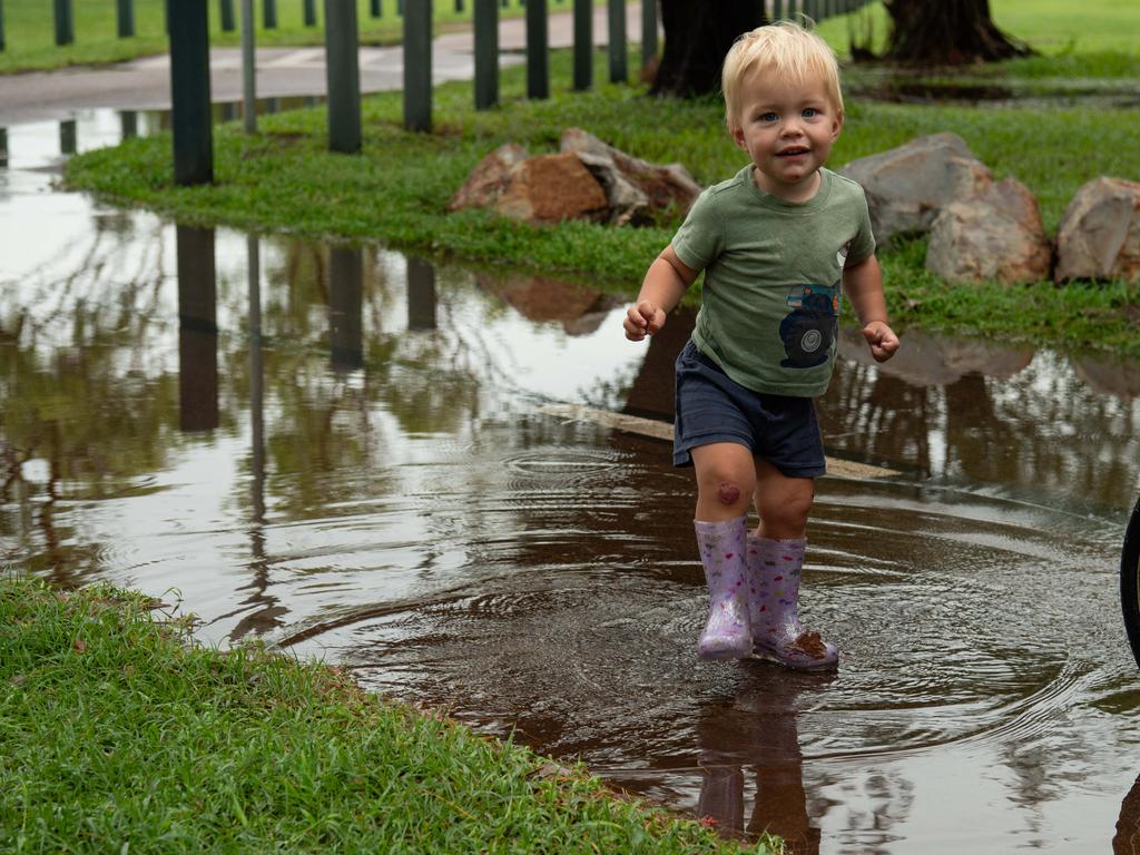
Darwin’s monsoon returned with a vengeance on Sunday night, dumping an extraordinary amount of water on Darwin and surrounds, with significant falls continuing on Tuesday.
The bureau now believes there is a 30 per cent chance – defined as a moderate risk under its criteria – of a tropical cyclone forming later this week, most likely on Friday.
“Tropical low 07U is forecast to form in the western Gulf of Carpentaria by Wednesday morning,” it said in an update published on Tuesday morning.
“[The low] is expected to be slow moving in the Gulf of Carpentaria. It has a moderate risk of being a tropical cyclone on Thursday, Friday and Saturday morning.
“Even if it doesn’t develop into a tropical cyclone, parts of the Gulf of Carpentaria coast could experience strong to gale force winds and heavy rainfall.
“On Friday, [the low] is likely to start moving to the west, taking it over the Gulf coast late Friday or early Saturday, where it will weaken.

“Over the weekend and early next week, [the low] is expected to move west over central Northern Territory and then northern Western Australia.”
A flood watch for the western Top End rivers, and Waterhouse River, remains current.
“Catchments in the flood watch area are relatively wet due to rainfall over recent weeks and are likely to respond relatively quickly to further heavy rainfall.,” the bureausaid in its alert.
“Daily rainfall totals of 40–80 mm over the flood watch area are expected, with the highest falls likely about the western and northwestern coasts, where falls of over 120mm are possible.”
Parts of Darwin received more than 100mm of rainfall in the 24 hours to 9am Tuesday, while additional amounts of between 20–36mm fell across greater Darwin between 9am–3pm Tuesday.

Dark skies dump another 100mm on Darwin overnight
Tuesday, 10.30am: Sodden Darwin has received another drenching, with parts of the city recording more than 100mm of rainfall in the past 24 hours.
However, in pleasing news for Top End motorists, there has been no repeat of yesterday’s traffic carnage, when the deluge’s peak coincided with the high tide, causing a trio of major arterials in the northern suburbs to become impassable.
According to Bureau of Meteorology figures, Leanyer, Royal Darwin Hospital, Marrara, Thorak Cemetary, Humpty Doo and East Arm all received more than 100mm of rainfall in the 24 hours to 9am Tuesday.
Pinelands, Howard Springs, McMinns Lagoon, Darwin Botanical Gardens, Charles Point, Wagait Beach, Darwin Airport, Nightcliff Pool and Noonamah Airstrip all received more than 80mm.
On Monday, Northern Territory Emergency Service director Fleur O’Connor warned that parts of Darwin may be at risk of flash flooding as the sodden ground had already absorbed as much water as it could.

Bureau meteorologist Rebecca Patrick said that, if the low pressure system currently interacting with the monsoonal trough continued to develop, it could form into a tropical cyclone as it moves eastwards towards the Gulf of Carpentaria.
Outside of Darwin, much of the northwest also saw heavy falls, although nothing approaching the strength of Darwin’s.
Parts of Adelaide River and Katherine received more than 50mm, while Wadeye, Bullo River, Daly River and Tipperary all received between 29–47mm.
Top End could see tropical cyclone if system keeps developing: BOM
Monday, 4.30pm: The Top End is at risk of seeing a tropical cyclone develop later in the week, the Bureau of Meteorology says.
The bureau provided a weather update on Monday afternoon, after parts of Darwin saw the highest single-day rainfall since 2017, leading to traffic chaos during the morning commute. as key arterial roads in the northern suburbs were severed by surging waters.
Senior meteorologist Rebecca Patrick said a monsoonal trough was interacting with a developing low pressure system, causing significant rainfall.
Should the system continue to build, it could develop into a tropical cyclone later in the week as it moves eastwards towards the Gulf of Carpentaria, Ms Patrick said.
“We’re still keeping a close eye on that area and all communities in those gulf and interior regions should keep up to date with the latest warnings,” she said.
Ms Patrick said heavy falls in the Darwin area – between 50–100mm is expected on both Tuesday and Wednesday for parts of the city – would likely come overnight and may be accompanied by storms.
The bureau issued an initial flood watch for the Territory’s northwest coastal rivers and Waterhouse River on Monday afternoon, advising of possible minor flooding.
“Catchments in the flood watch area are relatively wet due to rainfall over recent weeks and are likely to respond relatively quickly to further heavy rainfall,” the bureau advised.
“Daily rainfall totals of 40–80 mm over the flood watch area are expected, with the highest falls likely about the western and northwestern coasts, where falls of over 120mm are possible.”
Flash flooding warning: Darwin rainfall event to continue for days
Monday, 12pm: Parts of Darwin can expect up to 100mm of rain each day until Wednesday, leading to the strong possibility of flash flooding, the director of Northern Territory Emergency Service says.
A number of key arterials were severed on Monday morning amid the return of torrential monsoonal rains that hit the city’s northern suburbs especially hard.
Speaking just before 11.30am, NTES director Fleur O’Connor said flooding at Rapid Creek reached 3.19m, a centimetre below moderate level.
This was caused by monsoonal rain coinciding with the high tide, she said.
Flooding in the northern suburbs was expected to ease throughout the day with the recession of the high tide.

Ms O’Connor said advice from the Bureau of Meteorology suggested that parts of Darwin could receive between 50–100mm each day until Wednesday, which, combined with the extraordinary levels dumped in the 24 hours to Monday morning, meant flash flooding was a strong possibility.
“Please be aware that roads may be affected by flash flooding over the next couple of days, obviously residents in Darwin and the northern suburbs would have experienced a delay in driving into the city or on their way to work this morning,” she said.
“We had a number of road closures because of the flooding at Rapid Creek.
“We just want to remind residents to drive to the conditions, use your headlights and if it’s flooded, forget it.”
Ms O’Connor said the monsoonal trough, combined with a developing tropical low, meant much of the Top End could experience significant rainfall over the coming days.
She said that NTES had received two requests for assistance, at Nightcliff and Alawa, relating to floodwaters encroaching on property.
Volunteers had been dispatched to reinforce these two properties with sandbags, Ms O’Connor said.
The weather bureau is expected to provide a further update at 2.30pm.
‘Cars floating flooded’: Major Darwin roads cut by torrential rain
Monday, 10am: A number of key arterials in the Darwin area have been severed by monsoonal rains of fierce intensity.
SecureNT, the government’s emergency alert system, advised motorists to avoid parts of McMillans Rd and Trower Rd near Rapid Creek, and Bagot Rd in Ludmilla, due to “the significant wet weather”.
In a statement posted to social media, Northern Territory Police, Fire and Emergency Services said the affected sections were “impassable”.
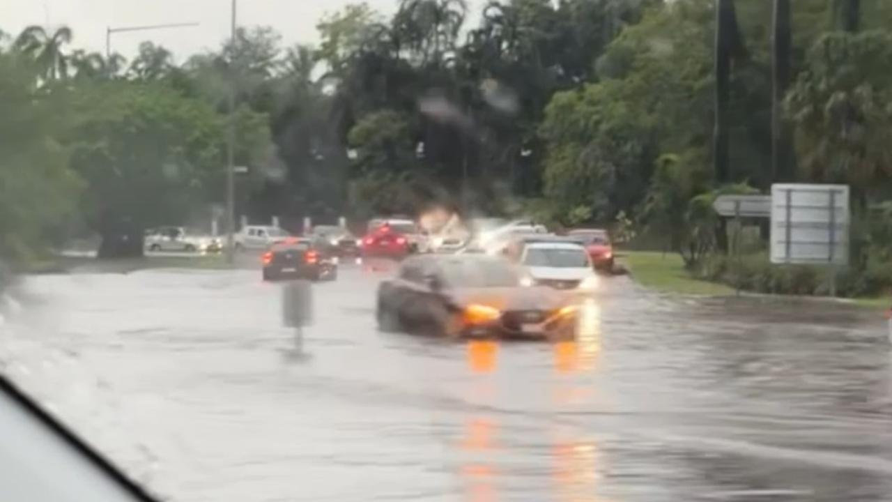
“Due to the relentless heavy rainfall, sections of Trower Rd and Rapid Creek Rd are currently impassable due to flooding,” it said.
“Your safety is our top priority, and we urge everyone to avoid these areas until further notice.
“️NT Police are closely monitoring the situation, and emergency services are on high alert.”
According to Bureau of Meteorology figures, parts of Darwin received extraordinary amounts of rainfall in the 24 hours to 9am.
Darwin Airport has received 165mm, Nightcliff Pool 158mm, Marrara 154mm, Leanyer 146mm, Ludmilla 140mm and Pinelands 136mm.
The rain has been less severe, although still torrential, in areas surrounding Darwin.
Charles Point has received 92mm and Howard Springs 83mm in the last 24 hours.
More Coverage

One Darwinite took to social media to describe the morass near the intersection of Bagot and Trower roads.
“Trower [Rd] is completely flooded. Like cars floating flooded. Out the front of KFC and Jape [Homemaker Village],” he said.
“Go through Fannie Bay to get to the city.”
Read related topics:Weather
Join the conversation

Talking wine bottles, washing machine drama: Free film festival line-up revealed
An Australia-wide film festival is headed to Alice Springs for the first time, and it’s bringing some highlights from the world of international cinema – for free. Find out more.
Read more
House of the week: Foreshore nearby, for sure to impress
A substantially renovated elevated home is new to the market in one of Darwin’s most sought-after suburbs. Take a look inside.
Read more

What’s on: Tasty Territory surprises and AFL grand final tips
In the Territory, we do things a little differently – down to the way we run our grocery stores. You may find more than you bargained for, writes Kate Dinning.
Read more