America’s meteorological organisation says odds of ‘strong’ El Nino over 95 per cent
Scientists have warned a “strong” El Nino system is likely this summer, as Aussies are urged to prepare for a dangerous fire season.
Scientists have warned this year’s El Nino is likely to be a “strong” one and may mean high ocean temperatures that “substantially exceed” those that were seen in 2016.
America’s National Oceanic and Atmospheric Administration’s (NOAA) latest El Nino update declared there was a more than 95 per cent change the climate event will last through to February 2024, with far-reaching climate impacts.
“El Nino is anticipated to continue through the Northern Hemisphere winter,” NOAA wrote in the update.
“Our global climate models are predicting that the warmer-than-average Pacific Ocean conditions will not only last through the (Northern Hemisphere) winter, but continue to increase.”
Sea surface temperatures in the east-central tropical Pacific have already soared abnormally high — an early sign that a strong El Nino is on the cards, NOAA said.
The temperatures exceeded the long-term average for 1991 to 2020 by 1C throughout the month of July. Temperatures from May to July were 0.8C higher than usual.
“We need to see five consecutive three-month averages above this threshold before these periods will be considered a historical ‘El Nino episode’,” the update said.
“Two is a good start.”

Why is Australia at odds with the world on El Nino?
The NOAA officially announced the onset of El Nino in early June, but its Australian counterpart has yet to declare the climate event will occur at all.
In fact, most international meteorological organisations, including the World Meteorological Organisation, have announced El Nino is already underway, but Australia’s Bureau of Meteorology is at odds with the rest of the world.
Many meteorological organisations have different definitions for declaring the climate driver, with the BOM using a stricter threshold. In its latest climate update on Tuesday, the BOM still had the odds of El Nino pegged at 70 per cent.
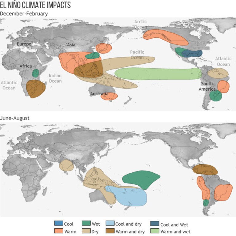
Australia is particularly vulnerable to the impacts of both El Nino and La Nina, with the former bringing hotter, drier weather particularly in Australia’s eastern states.
The weather system is linked to some of the worst bushfires in Australian history, including Ash Wednesday.
Authorities warn of a dangerous fire season
Aussie fire authorities have warned, whether El Nino is officially declared Down Under or not, a hot, dry summer is still likely.
Three subdued fire seasons under the La Nina climate pattern have resulted in large amounts of new grass and vegetation that could catch alight, according to Australasian Fire Authorities Council CEO Rob Webb.
“We often think of La Nina and we equate it with flood conditions across the eastern part of Australia, but what it also brings is large amounts of grass growth,” Mr Webb said.
“What we’ve seen over three years is a large amount of fuel over central and northern New South Wales, and into Queensland, and into the Northern Territory.
“So eventually, when the climate dries out, that grass fuel tends to become like tinder and that increases the risk.”
Grass fires are often publicly assumed to be less dangerous than forest or bushfires, but in fact they tend to start easily and can spread up to three times faster.
Grass fires have ripped through the Top End and Central Australia in recent weeks, with authorities predicting 80 per cent of the NT will burn by March.
Mr Webb said this summer’s fire season was unlikely to be another Black Summer, but he urged Australians to get prepared.
“We’ll be watching closely to see how quickly those fuels dry out, how quickly the temperatures increase into the summer months,” he said.
“It only takes a short time of the 40-plus temperatures and very windy conditions to create that tinderbox that you need to drive bushfires.”


