La Niña to last till August and Spring, rain to continue
With La Niña predicted to continue for months and potentially into spring, another developing weather system could bring even more rain.
More wet weather is forecast to hit Australia and the southern hemisphere, with another weather system bringing more rain into winter and spring.
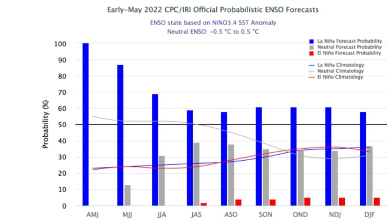
Recent research suggests there’s a “high probability” (62 per cent) of La Niña, which began more than 18 months ago, continuing into June and August, with a 55 to 60 per cent chance of the event lasting into the spring.
This means Australia could continue being lashed by above average rains, the likes of which have caused disastrous flooding in NSW and Queensland.
It would be only the fourth triple La Nina observed since 1900, and the first time the phenomenon had occurred in 22 years.
The numbers were compiled on behalf of Columbia University’s International Research Institute for Climate and Society (IRI) and US Climate Prediction Centre (CPC).
Stream more weather news live & on demand with Flash. 25+ news channels in 1 place. New to Flash? Try 1 month free. Offer ends 31 October, 2022 >

The continuation of La Niña into winter, let alone onwards into spring, is uncommon for the weather phenomenon.
“Typically by late autumn a La Niña has weakened and Pacific Ocean temperatures have returned to normal but that transition has not happened this year which explains why heavy rain is lingering,” Sky News’ Chief Meteorologist Tom Saunders previously told news.com.au.
Mr Saunders also hypothesised it was “quite likely La Nina will return for a third consecutive year”.
While the meteorological phrase, La Niña, has since become embedded in the psyche (albeit begrudgingly), there’s another bit of weather terminology Australians should acquaint themselves with.
Negative Indian Ocean Dipole forming
Bound by Asia, Africa and Australia, the activity observed in the world’s third-largest ocean – the Indian Ocean – is also threatening a prime sunny winter.
Sustained changes between the sea surface temperatures in tropical western and eastern sides of the Indian Ocean are key climate driver in Australia.

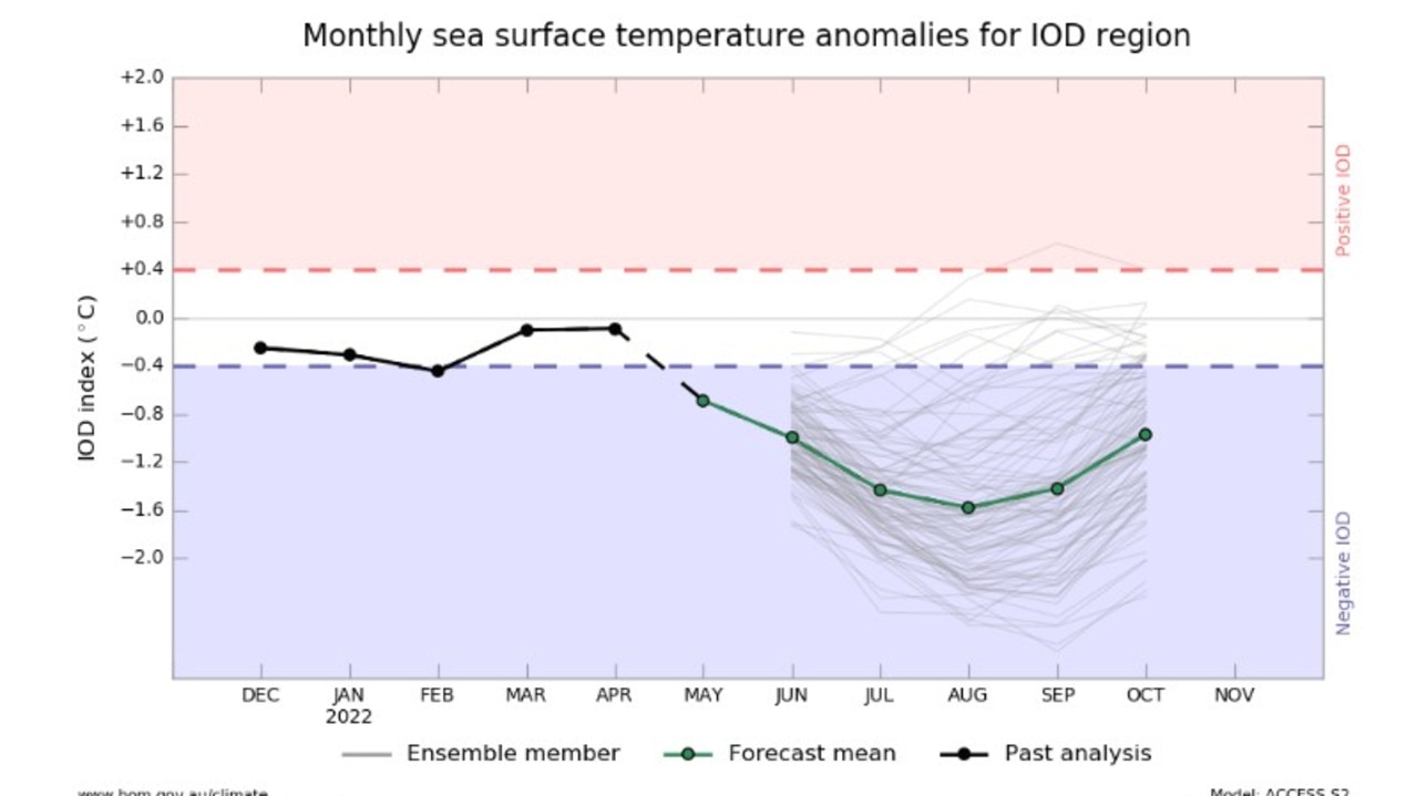
Officially known as the Indian Ocean Dipole (IOD), the weather system records neutral, positive and negative phase, with negative IOD phases resulting in above-average winter to spring rainfall across southern Australia. A negative IOD also occurred in 2021 and 2016.
On Monday, Mr Saunders said warmer water temperatures were recorded on the east coast of Indonesia, while rapidly cold “anomalies” were developing off the Horn of Africa.
“For the first time we had an IOD value below the negative threshold of -0.4,” he said.
“It means the Indian Ocean version of La Niña is rapidly forming and if it does form and sticks around, which is likely to, we’re looking at exceptionally wet winter and spring across the country.”
The real action is not at the polling booths but off the Horn of Africa. This little blue patch could have huge ramifications on our weather for 6 months. IOD index has fallen to -0.55, below neg threshold of -0.4. Chance of sunshine fading by the day.@SkyWeatherAUS@SkyNewsAustpic.twitter.com/twz4RQZs7S
— Thomas Saunders (@TomSaundersSNW) May 23, 2022
Effects of ‘likely’ IOD beginning
The developing IOD is already having effects on the weather in Western Australia. The northern part of the state has been forecast widespread totals of 20 to 50mm, despite the area normally recording a monthly average of just 10 to 25mm.
“Because of that developing negative Indian Ocean Dipole, you’re seeing moisture coming in from the northern Indian Ocean across the northern part of Western Australia and often this leads to the formation of northwest cloud bands across most of Australia,” Mr Saunders said.
He has previously revealed the last time a negative IOD collided with a La Nina was in 1974, which was “Australia’s wettest year in 122 years of data”.
âš ï¸Batten down the hatches a Severe Weather Warning is current for WA, including #Perth. Its going to get wild tonight with widespread winds gusting to 100km/h and isolated gusts over 125km/h! A system this strong only impacts WA twice a year. The latest https://t.co/j5pA6eRd39pic.twitter.com/MEgigjpWcN
— Bureau of Meteorology, Western Australia (@BOM_WA) May 23, 2022
Australia’s east coast has been forecast to be hit with showers and the occasional thunderstorm in coastal regions of NSW and southern Queensland. Although the rain is expected to clear in central and southern NSW by Thursday, showers are “likely to continue” in southern Queensland.
Despite the 50mm of rain forecast for NSW’s east coast, Mr Saunders said the upcoming week will be one “one of the driest weeks we’ve had”.


