
Wet weather at end of school holidays, but heat on the way
Torrential rain lashed parts of the state on Friday afternoon, as Melbourne looks ahead to a wet weekend.


Victoria
Don't miss out on the headlines from Victoria. Followed categories will be added to My News.
Torrential rain lashed parts of the state on Friday afternoon, as Melbourne looks ahead to a wet weekend.
Storms swept through Geelong, the Bellarine Peninsula and across the bay to the Mornington Peninsula, with heavy rain and thunder late on Friday.
After a balmy Thursday, the heavens are also set to open on Saturday and Sunday in Melbourne, with temperatures dipping.
Those heading into the city on Saturday will experience a top of just 19 degrees and there’s a 95 per cent chance of rain, which will see the Melbourne Show close on a damp note.

Despite the wet weather, the UV index is predicted to reach high levels when the sun comes out.
The Bureau of Meteorology is predicting the same maximum and minimum temperatures on Sunday as Saturday — a low of 12C and top of 19C.
The wet weather marks the beginnings of a hellish hayfever season for sufferers, and is expected to cause a rapid increase in grass growth and extreme pollen later this season.
Rain will continue into Monday with a top of 20C before clearing up for the most part on Tuesday with a top of 15, with small showers expected only during the morning.
The sun will be back out on Wednesday for a top of 21C.
Heat on the way
However, Victoria is in for an unusually warm lead into summer.
The BOM has predicted an 80 per cent chance of maximum temperatures soaring above medians across the state at the end of the year.
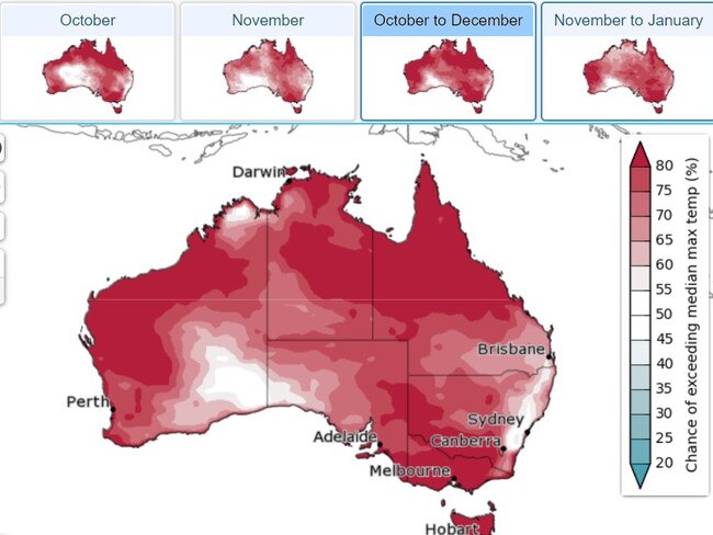
Historic data shows the average maximum temperature in Melbourne is 19.7 degrees in October, 22C in November and 24.2C in December.
Based on the BOM’s predictions, it’s likely the January average will be 25.9 degrees.

The prediction comes as the El Nino – Southern Oscillation (ENSO) remains mostly neutral, with just a slight tip towards La Nina.
La Nina is associated with the warming of Pacific Ocean temperatures, causing for a greater likelihood of cloud development and rainfall across Australia. The event has been associated with major flooding events in recent history.
However, in an October 1 release, the BOM said while some atmospheric indicators have “been more La Nina like over the past few weeks”, there was yet to be a “consistent” signal to imply we were in for a La Nina event.
“Should a La Nina develop in the coming months, it is forecast to be relatively weak (in terms of the strength of the SST anomaly) and short-lived, with all models indicating a return to neutral by February,” the BOM wrote.
So heaps of rain, but we can’t put it down to La Nina — a Bureau spokesperson calling the climate systems “complex”.


Good Friday Appeal raises record $23m+ for Vic’s sick kids
The Good Friday Appeal has raised a record $23,822,792 for the state’s sickest kids as Victorians generously donated to help the Royal Children’s Hospital.

Mokbel enjoys Good Friday with mystery partner as he laps up freedom
Tony Mokbel has been spotted enjoying his new-found freedom on Good Friday, picking up a copy of the Herald Sun before heading to church and tucking into fish and chips with his partner.