
Winter arrives a few days early: Heavy rain and snow hits the state
Melbourne is in for a chilly start to the week, but the cold front is welcome news for ski lovers ahead of the official start to the snow season.
VIC News
Don't miss out on the headlines from VIC News. Followed categories will be added to My News.
Melbourne is in for a chilly start to the week in a sign of things to come after heavy rain bucketed down across Victoria overnight.
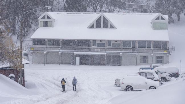
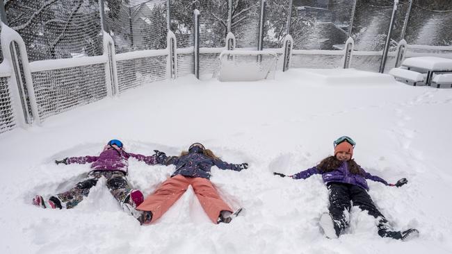
But the Antarctic blast is welcome news for ski lovers, with the alpine regions being blanketed in fresh powder ahead of the snow season officially beginning on June 8.
Between five and 15mm of rain fell in storms across Melbourne as power went out across metropolitan areas overnight.
About 5mm was dumped in 10 minutes across some suburbs.
Hurstbridge had the heaviest falls in Melbourne with 15mm, while the CBD copped 8.2mm.
The most rain in Victoria fell at Harrietville with 26.8mm.
Victoria is in for more rain today but wind chill will mean it feels way colder than what it is.
Melbourne is in for a maximum of 13C today, while Ballarat is set for a top of just 9C.
Further showers & a mix of sun & cloud expected across Victoria today with local hail & thunder. Snowfalls also likely above 700m elevation. Gusty winds will make it feel even colder - the apparent temperature is currently -1°C @ #Melbourne Airport! https://t.co/8AozJr6l6e 2/2
— Bureau of Meteorology, Victoria (@BOM_Vic) May 26, 2019
Heavy snow began falling around 10pm last night at Mt Hotham, with the popular resort getting about 25cm of fresh powder.
It's dumping #snow at #Hotham. 25cm+ of fresh #snowfall and counting. ☃ï¸â˜ƒï¸â˜ƒï¸ pic.twitter.com/zstrrMImb3
— Hotham (@_hotham) May 26, 2019
The 1st #snow front has arrived. It's #intense!! Perhaps 20cm by the morning. ☃ï¸â˜ƒï¸â˜ƒï¸ #Hotham #coldsnap pic.twitter.com/xpwnYRoSvr
— Hotham (@_hotham) May 26, 2019
Waking up to WHITE â„ï¸ and snowmaking this morning -4 #snow #mtbuller 12 days to opening @SNOWSEARCH_aus @JaneBunn @abcnews pic.twitter.com/v7y0EmtCX6
— Mt Buller (@mtbuller) May 26, 2019
Only 11 sleeps until the 2019 snow season 🙌🼠#snowday pic.twitter.com/19gX9UenOR
— Falls Creek Official (@fallsaustralia) May 26, 2019
It started dumping SNOW at midnight and plenty more coming at Mt Baw Baw!! So good!! â„ðŸ˜
— SNOWSEARCH australia (@SNOWSEARCH_aus) May 26, 2019
Video: Pray4Snow Tall Hoodies pic.twitter.com/DDUofRIXGo
Snow is expected to fall to around 700m today.
Further snowfalls are expected into Thursday with series of cold fronts
Bureau of Meteorology’s Richard Russell said there could be some showers into the afternoon and warned people to rug up as the temperature plummets.
After a run of days reaching 20C last week, Victorians will get a reality check as Winter officially starts on Saturday.
The temperature won’t jump above 16C all week in Melbourne, with Wednesday’s high of 12C coming with the chance of a thunderstorm.
MORE: VICTIM IN HORRENDOUS ROYAL PARK SLAYING IDENTIFIED
MAL BROWN: I’M NOT APOLOGISING
Authorities have urged drivers to stay alert during wet and windy weather on roads with driving conditions set to be dangerous.
There were power outages in Yarraville last night, with more than 2800 homes without electricity.

‘Angels’: Hero Coles workers save mum’s life
A mother of three has opened up on how her life was saved after she suddenly collapsed while doing a routine supermarket shop.
Wildlife and traffic fears over music festival
Wildlife advocates fear a weekend music festival in central Victoria will endanger native animals including rescued joeys.