How Southbank transformed from marshland to one of the busiest areas in Melbourne
IT was once a smelly, polluted, industrial wasteland. Today it’s home to glittering towers and office blocks. How Southbank rose to become the most densely populated part of Melbourne.

VIC News
Don't miss out on the headlines from VIC News. Followed categories will be added to My News.
ONE of the most densely populated areas of Melbourne, Southbank is a hub of high-rises, entertainment, business and dining.
But it wasn’t always so flash.
From a tent city during the gold rush years, to a hive of industry in the 20th century, Southbank has had many incarnations.
Once considered to be part of South Melbourne, itself formerly known as Emerald Hill, the area around Southbank was originally made up of swamp and wetlands.
ARTS CENTRE TO BECOME WORLD-CLASS ATTRACION
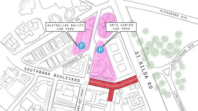
ROAD CLOSURES HERALD START OF SOUTHBANK MAKEOVER
CITY COUNCIL PLAN FOR $2M ARTWORK IN SOUTHBANK
While the European settlement of Melbourne began in 1835, the area south of the Yarra remained relatively undeveloped until Emerald Hill was surveyed and subdivided in 1852.
Crossing the Yarra to what is now Southbank wasn’t exactly easy, either.
Before the first permanent bridge was opened in 1851, Melburnians had to rely on punt and ferry operators to get from one side of the river to the other.
Called the Lennox Bridge, it was erected on the site of the present day Princes Bridge.

TENT CITY
The beginning of the gold rush in the 1850s caused an influx of migrants to flock to Victoria, with many setting up camp in Melbourne.
With the city’s population rising faster than extra accommodation was able to be built, a tent city called Canvas Town popped up south of the Yarra.
While the first tents were pitched on the banks of the river, the Yarra’s propensity for flooding resulted in them being moved to higher ground.
Canvas Town was described in the Emerald Hill Record as, “spread over an area extending from the higher ground south of the Yarra between Princes Bridge and Queens Bridge to the slopes of the Domain, on the southeast and westward to the area bounded by City Rd.”
“The tents were pitched in street alignment, and included shops, lodging houses, eating houses and a hospital — all canvas.”
In 1852, the site was legalised by then governor Charles Latrobe, and a weekly rent of five shillings per tent was imposed.
Built on the corner of Clarendon and Banks streets, the first school in the area even took its name from the tent city.
In 1853, the Immigrants’ Aid Society was established to assist with the city’s influx of impoverished men and families, who had arrived to try their luck in the gold fields.
Largely funded by benefactors, it was located on the western side of St Kilda Rd, just south of Canvas Town.
The high rates of migrants also caused a large increase in the number of people crossing the original Lennox Bridge.
This, combined with increased shipping traffic on the Yarra, led to the bridge being replaced and renamed in 1888.
Home to about 8000 people of different nationalities and classes at its peak, Canvas Town eventually became a slum and was abolished by the government.


EARLY ENTERTAINMENT
Not only home to Canvas Town, several forms of entertainment have also been in and around the Arts Centre Precinct since the 19th century.
The site was home to travelling circuses in the late 1800s until a permanent venue was established in 1901.
Called the Olympia, the building housed the Fitzgerald Brothers’ Circus which was renowned for its flying aerial performers, Japanese Sumo wrestlers, and performing ponies, Mahomet and Commodore.
Three years later, an amusement park called Princes Court popped up on the site, adjacent to the circus buildings.
Featuring a miniature motorised railway, a Japanese tea-house and the famous Canadian Water Chute, Princes Court lasted for five years before closed its doors in 1909.
After the Fitzgerald brothers’ sudden demise in 1906, Wirth’s Circus took over the Olympia.
The family renamed the site Wirth’s Park and built a hippodrome, racetrack, roller-skating rink and lake in the grounds.
A success for many years, the economic downturn following World War II resulted in a decline in circus attendance.
The final nail in the coffin came in 1953 when a fire ripped through the park causing an estimated £70,000 damage bill.
In September 1926, the Green Mill dance hall opened on the corner of St Kilda Rd and Sturt St, where the National Gallery of Victoria now stands
Named for its replica of a Dutch windmill, the venue boasted “modern dancing to the music of Morm McInnezs and his band”.
After the Great Depression caused declines in attendance, the venue was relaunched as the Forty Club in 1933, before becoming the Trocadero a few years later.
In January 1941, a fire hit the venue causing an estimated £10,000 in damage.
The Trocadero lived on for more than a decade, though, only closing its doors in the mid-1950s.
Australia’s second indoor ice skating rink also found its home in Southbank.
Opening in June 1906, the Melbourne Glaciarium occupied about an acre of land along City Rd, where the Southgate Towers now stand.
After hosting Australia’s first ice hockey game, it became home to Australia’s first ice hockey association.
In 1920, the Glaciarium’s ice floors were abolished in favour of converting the venue into a dancehall.
Its owners later arranged to divide the floor so that both dancers and iceskaters could enjoy the space.
After housing the basketball and gymnastics competitions during the 1956 Melbourne Olympics, the Glaciarium closed in 1957.


INDUSTRY GALORE
Southbank’s reputation as a hive of industry began in 1868 with the establishment of Ramsden’s Paper Mill.
Siting on the south bank of the Yarra to the west of Princes Bridge, it was the first paper mill in Victoria.
In May 1968, 100 copies of The Evening Star newspaper were published on the first sheets of newsprint produced by Ramsden’s mill.
Tragedy struck in January 1873 when a fire tore through the mill, causing an estimated £3,000 damage.
In 1895, the Southbank, Geelong and Broadford paper mills were combined to form the Australian Paper Mills Company, which later became known as Australian Paper Manufacturers Ltd.
The popularity of Southbank increased over the succeeding decades with The Herald reporting in 1926 that the vacant land along City Rd was ripe for development.
With plots valued at £60 to £70 a foot, it was significantly cheaper than land on the other side of the Yarra.
In 1947, Australian Paper Manufacturers Ltd, bought a site on Riverside Ave, now known as Southbank Promenade, for £20,000.
Southbank was also home to several food and drink manufacturers.
In 1888 Castlemaine Brewing built a brewery on Queensbridge St, followed in 1892 by a malthouse on Sturt St.
The malthouse later transferred to Barrett Bros & Burston & Co., and had stopped operating altogether by the 1970s.
When the Playbox Theatre Company found itself without a home in 1986, the malthouse’s then owners Carlton & United Breweries donated the building to the company to refurbish.
Retaining its ties to the beer making industry, it is now known as Coopers Malthouse, home of the Malthouse Theatre.
Many other manufacturers found their homes along Riverside Ave, including Kraft Cheese, Allen’s Sweets and Senitt’s Ice Cream.
Allen’s was of particular significance owning to the large neon sign that adorned the factory’s roof from 1955.
In 1987, the Allen’s factory was relocated to make way for Southbank’s redevelopment and the sign was demolished.


URBAN RENEWAL
Between the 1970s and early 1990s, the area along the south bank of the Yarra River between Princes and Spencer St bridges was subject to substantial redevelopment.
While the National Gallery of Victoria’s International building opened on St Kilda Rd in 1968, the rest of the arts precinct didn’t begin construction until 1973.
Taking over the site that was home to Snowden Gardens and the Southgate fountain, Hamer Hall was the first building to be completed.
It opened in 1982, followed by the Theatres Building two years later.
Riverside Ave was transformed into Southbank Promenade in 1990, making way for the completion of Southgate, The Herald & Weekly Times Ltd and IBM towers, and the Sheraton Towers Hotel in 1992.
The opening of the opulrnt Crown Casino and Entertainment Complex in 1997 ensured the gritty chapter of Southbank’s history was well and truly closed.


