
Thunderstorms hit Melbourne, West and South Gippsland
Heavy rain has lashed the eastern suburbs this afternoon, with a flash flooding warning in place in Pakenham as thunderstorms threaten Melbourne for a second day.
News
Don't miss out on the headlines from News . Followed categories will be added to My News.
More rain and wild weather has hit Melbourne this afternoon, with a flash flood warning in place for Pakenham.
Yesterday, hail stones the size of golf balls fell across the eastern suburbs, causing extensive damage to cars and properties.
Today, similarly bad weather is forecast again over the east.
Richard Russell, a senior forecaster at the BOM, said Melbourne’s east was expected to take the brunt of the storm.
“The outer eastern and south eastern suburbs have been impacted most by the heavier rain,” he said.
“There’s one (thunderstorm) in Pakenham … we’ll see that continue across the eastern suburbs.”
A warning has been issued for Pakenham residents with flash flooding wreaking havoc in the area.
The warning, on the Vic Emergency website, reads:
“If you are located in Pakenham, you are in danger.
“You should immediately move indoors, away from floodwater.
“Do not enter floodwater.”
Motorists are being urged not to enter flood waters and to instead take an alternate route.
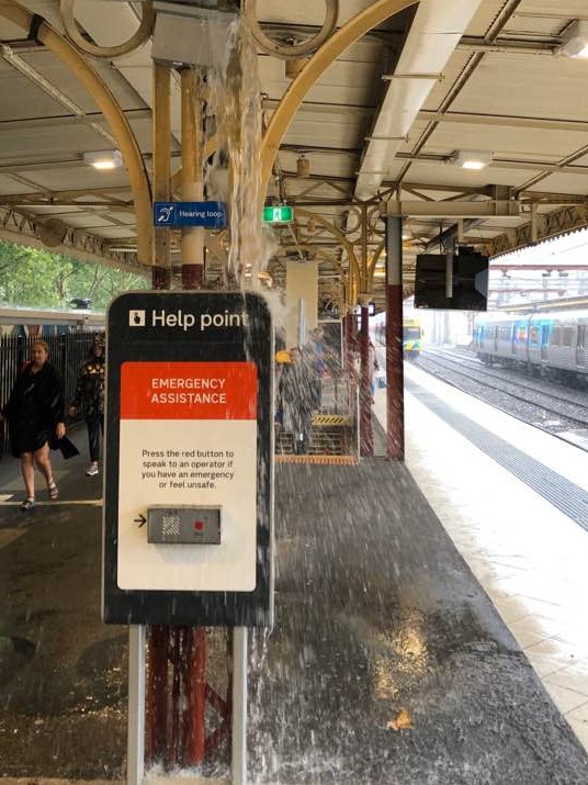
In the city, rain poured through holes in platform covers at Flinders Street Station.
In the east, Glen Iris, Malvern East and Warrandyte have been the hardest hit.
“What we can expect over the rest of the afternoon and evening, we’ve still got thunderstorms over those suburbs,” Mr Russel.
“There’s still a fair bit of shower activity … (over) most of the city.
“As we get into the late evening, all we’ll have left is isolated showers … clearing away early tomorrow morning.
“By the time most of us get up it should be clear.”
In the 24 hours to 2.30pm today, the SES had responded to 1705 calls for help across the state.
In Melbourne alone, 1548 calls had been received.
In the last hour there has been an increase in requests for help from the Pakenham area, a State Control Centre spokeswoman said.
One person had to be helped from their home in Pakenham as water began flooding in from the street.
SES crews attended and sandbagged the home in a bid to stop the deluge.
And a man also has been pulled from the water at Docklands as the city is lashed by wild weather for a second day.
The man was reportedly left struggling after falling from a bridge, an SES spokesperson said.
Paramedics confirmed they had transported a man to the Royal Melbourne Hospital in a stable condition.
âš ï¸Severe Thunderstorm Warning for eastern and parts of northern Melbourne. Severe thunderstorms are likely to produce heavy rainfall that may lead to flash flooding in the warning area over the next several hours.âš ï¸
— Bureau of Meteorology, Victoria (@BOM_Vic) January 20, 2020
See warnings: https://t.co/oVzsSl9pcT pic.twitter.com/IAT9HmdNKK
The flooding in Pakenham has caused peak hour chaos, with the Princes Highway outbound closed at Cardinia Road.
Police are directing motorists onto Cardinia Road, towards the Princes Freeway and McGregor Road.
Motorists are also being warned Racecourse Road has been closed between Bald Hill Road and Cameron Way due to flooding.
A statement from the Department of Transport says:
“Drivers, pedestrians and cyclists should never enter flood water.
“For the sake of a few minutes extra, it’s worth finding an alternative route, rather than getting stranded.
“Passengers taking public transport are encouraged to check for services impacted by the weather before travelling.”
Buses are replacing trains from Dandenong to Pakenham after a person was hit by a train at Berwick.
Intense rainfall and severe thunderstorms were predicted to whip up “dangerous and life-threatening flash flooding” in parts of regional Victoria this afternoon.
The wild weather was due to hit West and South Gippsland, Mallee, Northern Country, North Central and Wimmera districts.
Locations predicted to be affected include Morwell, Traralgon, Warragul, Sale, Moe, Maffra, Mt Baw Baw, Mildura, Ouyen, Swan Hill, Kerang, Walpeup, Birchip, St Arnaud, Bendigo, Echuca, Shepparton, Rochester and Castlemaine.
People in those areas were told to stay indoors, move vehicles under cover or away from trees and batten down loose items such as outdoor settings and umbrellas.
The second straight day of wild weather comes as the mop-up continues in Melbourne from yesterday’s damaging hailstorm.
The highest recorded rainfall yesterday was in Mt Elizabeth in the East Gippsland region at 67mm followed by Mt Wellington at 55mm.
These areas will most likely receive the same amount of rain today.
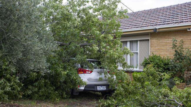
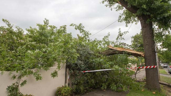
The hailstorm sent trees crashing down and took out multiple power lines in the eastern suburbs.
Mobile mechanic Harry Tsoumbakos said a power line was knocked down by a fallen tree at his Balwyn North house and a large tree fell on his grandmother’s car.
He was out at the time yesterday but said his 75-year-old grandmother described the flash flood as “unbelievable”.
“She said it was wild, crazy rain, hail and tearing winds,” he said.
Mr Tsoumbakos said his grandmother was “really shaken up”.
He said they were waiting for power lines to be moved before they could assess the damage to her car.
The hardest hit areas in Melbourne were Doncaster, Templestowe, Warrandyte, Balwyn, Glen Iris and Kew.
The storms will not subside until early Wednesday according to BoM.
AAMI spokesperson Angela Wilkinson said the insurer was experiencing higher call
volumes, however it was ramping up the capacity of its contact centres to ease
delays.
A Hail Assessment Centre will be established in Mount Waverley to assist customers
with damaged vehicles in the coming days – AAMI will update customers with
further details.
“The Centre is designed to quickly assess and triage all hail-affected vehicles, so we
can make the repair process as seamless and efficient as possible for our customers,” Ms Wilkinson said.
AAMI is urging insurance customers impacted by yesterday’s storms in Victoria to
lodge their claims as soon as it is safe to do so.
“We are urging customers to get in touch with us as soon as possible. The sooner
you contact us, the sooner we can start the claim process to ensure the quickest
possible path to recovery,” Ms Wilkinson said.
The SES were called to 1449 jobs across the state during yesterday’s deluge.
This morning 688 were recorded as completed, with 768 still active.
We might struggle to get a start immediately after tea. @WarrandyteCC pic.twitter.com/7DP7ZbWa8D
— Adam White (@White_Adam) January 19, 2020
The nature of the incidents responses to were building damage from wind gusts and hail storms, some flash flooding and a few hundred trees coming down, an SES spokesperson said.
The state will have a better idea tomorrow as to how helpful the rain has been in bushfire affected areas, however there are concerns the rain could cause ash and debris to affect waterways.
The SES said on days like yesterday and today, people should stay indoors and off the roads if possible.
I have never seen anything like this... Hail bigger than golf balls has brought the Monash freeway to a complete stop. #melbourne #melbourneweather pic.twitter.com/weZ909bWCM
— Liam Melrose (@liammelrose15) January 19, 2020
State Control Spokesperson Luke Heagerty said the wind and lightning that arrived with the storms presented several new challenges to crews in bushfire areas.
The potential for landslides and trees falling was far greater on days like yesterday and today, Mr Heagerty told 3AW.
Despite the fact the state is receiving significant rainfall, Mr Heagerty said it did not change the fact Victoria has had “months and months of below average rainfall.”
Mr Heagerty said aircraft support over the fires had been “fantastic” throughout the bushfire season so far, but on such stormy days like today, conditions could prevent aircraft from getting in the air.
Meteorologist with the BoM Dean Narramore said the state would not see the tennis-ball sized hail that lashed the state yesterday, and the storms would mostly bring heavy rainfall.
Mr Narramore told 3AW the storm yesterday was “the biggest in Melbourne metro since November 2017”.
Heavy rain will significantly hit areas in the northeast of the state and near the Murray.
Mr Narramore said 10-30mm of rain was predicted for the Melbourne metro area, while more broadly isolated totals 40-50mm are likely to occur.
The bulk of the rainfall will be this afternoon particularly as peak hour hits.
Residents in some suburbs should expect street flooding.
The storms have created some cooler weather for the week, with the hottest day coming on Wednesday at 30-31 degrees.
SUBURBS GET HIT HARD BY HORROR CONDITIONS
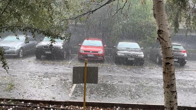
Glen Iris residents could only watch on as their vehicles were battered by hailstones the size of cricket balls when yesterday’s fierce storm hit about 4.15pm.
In one street, shattered car owners were left to survey cracked windows and golf ball-sized divots, with insurance claims set to rise into the hundreds of thousands of dollars.
Glen Iris was the hardest-hit area in the state, with State Emergency Service crews called to 386 incidents in the leafy inner-east suburb.
At 10.30am this morning the SES had received a whopping 1,539 requests for assistance in the past 24 hours.
Malvern’s unit was the busiest, dealing with 695 requests for assistance.
Manningham was also hit hard – volunteers from that unit were called to 363 incidents.
Malvern East had 205 incidents and Warrandyte residents made 168 requests for assistance.


The most common types of call-outs across the central region were for building damage (1,075), trees down (162) and flooding (134).
In the northeast, North Warrandyte was hardest hit, with the Nillumbik SES unit fielding about 60 calls in five hours from 3pm.
Unit controller Glenn O’Donnell said it was “amazing to watch” the storm come through on the radar.
“I thought it was going to miss us … but it stopped at Kinglake and took a sharp turn left towards us,” he said.
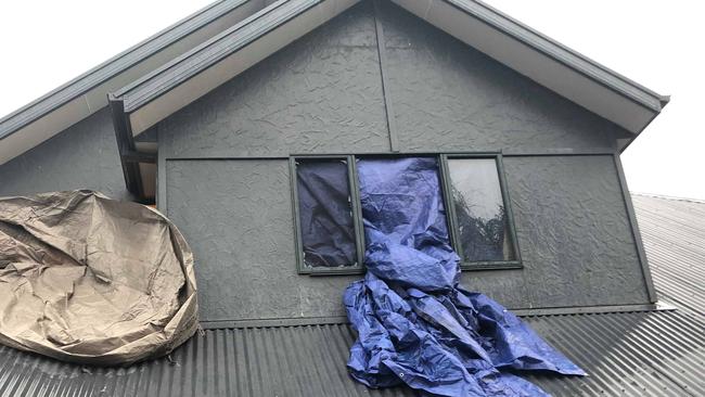
Mr O’Donnell said about 80 per cent of their call-outs were for roof damage, with tiles and skylights smashed by large hailstones and strong winds.
One photo shows a Nillumbik volunteer covering a damaged skylight surrounded by dozens of holes in a pergola roof.
MORE NEWS:
MAYWEATHER ANNOUNCES MCGREGOR FIGHT
COP ACCUSED OF THROWING HOT SOUP ON ROOMMATE
CHINESE TOURIST MYSTERIOUSLY VANISHES IN MELBOURNE
Mr O’Donnell said three crews were still out responding to a backlog of eight calls this morning.
He said the three hardest-hit roads in North Warrandyte were Valias St, The Boulevard and Weerona Way.
Next door Whittlesea SES only received eight calls for assistance but sent volunteers to help Nillumbik crews clean up.