
Swimmers flocked to the beaches of Western Sydney
Western Sydney is not blessed by surf but its major waterways were once the place to go for a dip

Today in History
Don't miss out on the headlines from Today in History. Followed categories will be added to My News.
Mention Sydney’s beaches and most people envisage the golden sands stretching to the north, east and south of the city. But the rivers of Western Sydney were once a boon for bathers who didn’t enjoy the long, hot slog to the surf.
Now Parramatta, Penrith and Liverpool Councils have announced plans to create waterside recreation areas to rival the coastal playgrounds in other parts of the city.
Parramatta plans to make its river swimmer friendly by 2025 and Penrith is planning improvements along the Nepean.
The Georges River will also be made swimmable again, a marina built and old industrial sites rejuvenated as residential areas while Liverpool Council is fighting to prevent a major freight terminal being built by the river.
The Georges River has been both a site of industry and leisure, going back even to the time before 1788. Running for about 96km from its source in the swamps of O’Hares Creek near Appin, the river is fed by about a dozen tributaries before it flows into Botany Bay. Centuries before any Europeans had ever seen it, indigenous people including Eora, Dharug, Dharawal and Gandangarra lived near the river they called Tuco-erah, Tuggerah or Toggerai.
The indigenous people caught fish and yabbies and collected oysters from its waters, while also enjoying the abundance of food and other resources found along its banks. The river had its sacred and dreaming significance and acted as a major transport artery but the Aboriginal people also enjoyed swimming in the river for pleasure.
When the British arrived to set up a penal colony in 1788 they initially dropped anchor in Botany Bay and noted the river that fed into the bay. The colony’s first governor Arthur Phillip named this river Georges River after King George III. Over the next few years several boats probed the near reaches of the river, but in 1795 Bass and Flinders sailed the Tom Thumb further along the watercourse in the first major white exploration of the river.
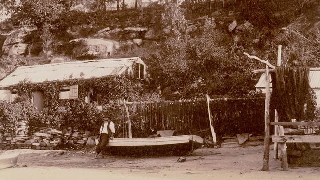
It was immediately apparent that steep sides and sandy soils along some stretches made it undesirable for farming, so many of the first residents along the river were fishermen and people living in scattered huts and harvesting oysters.
However, there were flatter spots along the banks where centuries of flooding had produced rich deposits of alluvial soil. The first land grants were given to government officials in 1798 and farms soon started occupying the area.
A house built by George Johnston, which became known as Georges Hall, served as an army outpost. It was served by a tent hospital, mainly for soldiers, by the river that in 1813 became a more permanent brick hospital.
The intrusion of the British was much to the annoyance of indigenous inhabitants, particularly Pemulwuy, who had been born near the river and waged a war on colonists until he was shot dead in 1802.
Aborigines were not the only danger to farming near the river. Floods plagued colonists as early as 1798. From the 1830s attempts were made to control the flow of the river, starting with the construction of a weir in 1837, ostensibly to create a water supply.
Industries also established along the banks of the river. In the 1850s a wool washing plant was built soon followed by a large abattoir. In 1868 a paper mill opened on the banks of the river near Liverpool.
The resulting pollutants that made their way into the river were of some concern to residents who enjoyed picnicking on the shores and to people who earned a living from fishing and oyster farming.
Closure of the paper mill in 1905 reduced some of the pollution but there were still other sources threatening the health of the river, not least the run-off from the growing population.
Before World War I army camps had been established by the river. These would become even more important in World War II, but a report in 1942 complained of the pollution being discharged into the water from the army camps.
It was of some concern because in the 1920s the river had become a popular recreation spot for bathers, amateur fishermen and for boating.
Silting had also become a problem because of the removal of native forests along its banks. In the 1960s areas of the shoreline were made into the Georges River National Park to try to conserve some of the natural environment.
Swimming areas along the river were closed by councils in the ’60s, but in recent years attempts have been made to clean the waterway.
Originally published as Swimmers flocked to the beaches of Western Sydney
Gallipoli to D-Day: Aussie’s epic war story
George Dixon went ashore with the original Anzacs at Gallipoli, aged just 15 – and was shot. Three decades later he was fighting again, at history’s other most famous wartime landing.
Love story behind escape tragedy
An Australian murdered in the infamous wartime Great Escape died after swapping places with another man. And his story is still unfolding, 80 years on.