
Maribyrnong feeling heat more than other suburbs due to lack of trees
There’s a simple solution to help everyone cope in the peak of summer. But population growth is getting in the way.
North West
Don't miss out on the headlines from North West. Followed categories will be added to My News.
Maribyrnong is one of the most vulnerable areas to the adverse impacts of increasing heat in Melbourne, according to an analysis by 202020 Vision.
The national initiative involving government, universities and business aims to increase urban green spaces by 20 per cent by 2020.
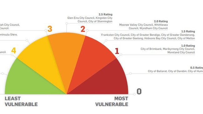
202020 Vision compiled a heat vulnerability index looking at each state, as well as all local government areas to assess the total number of hot days, the ability of the local population to remain healthy in the heat and the extent of green space.
READ MORE:
MELBOURNE WEATHER: BEST POOLS, BARS TO BEAT THE HEAT
ACTIVISTS CALL FOR DEVELOPERS TO PAY MORE TOWARDS OPEN SPACE
202020 VISION CALLS ON PLANNERS TO CREATE MORE SHADE TO TACKLE URBAN HEAT ISLAND EFFECT
The worst affected areas include parts of Melbourne and Adelaide.
Maribyrnong scored a one out of five for heat vulnerability, alongside Brimbank and Moreland.
Darebin, Hume and Ballarat were the worst off with a score of 0.5 while Yarra Ranges, Nillumbik, Knox and Bayside scored a 4.5 and were the least vulnerable to the heat.
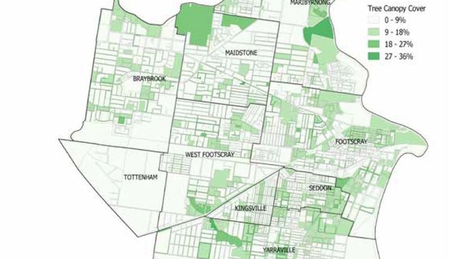
Maribyrnong Council’s Urban Forest Strategy said Maribyrnong had low canopy cover compared to most Victorian municipal areas despite intensive tree planting efforts, because the municipality is characterised by areas of industrial land, small parcels of parkland and narrow streets that do not support adequate levels of canopy cover.
Total canopy cover in 2018 was measured at 8.3 per cent, according to the council.
Between 2013 and 2016, Maribyrnong streets lost about 2.5 per cent of shrub and tree canopy cover, which was classed as a “significant decrease”.

Yarra was the only council area that had experienced significant increase in tree cover.
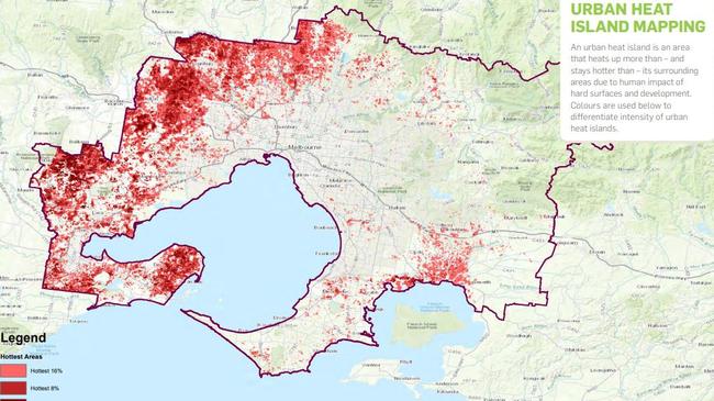
A lack of trees and shade is contributing to the urban heat island (UHI) effect, making it harder for many areas to keep cool in hot weather, the study found.
The effect occurs when built-up areas with surfaces such as roads, concrete and buildings absorb heat on hot days, increasing the temperature and retaining heat into the night.
In Melbourne, a heat continent surrounds Sunbury and Melton in the west.
The least heat-stressed LGAs were often those in the ritziest areas including Bayside in Melbourne.
Poorer outer suburbs often ended up far hotter than inner city enclaves.
202020 Vision lead researcher Marco Amati said the main reason there were fewer trees and shrubs was the competition for space for development and urban sprawl.
Mr Amati said residents could help keep their neighbourhood cool by creating as much green space in their gardens and nature strips as possible and watering any plants or trees that look stressed during heat spells.
“This might include putting buckets under showers to put onto the nature strip.”
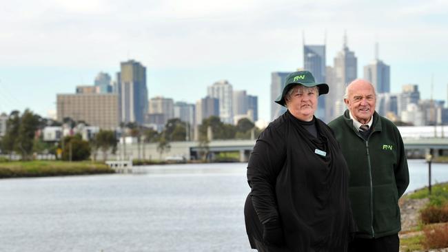
President of Friends of the Maribyrnong Valley Judy Ingham said heat in Melbourne’s western suburbs was particularly bad because it had less rainfall than other areas.
“Which makes us hot. We don’t get that clearing rain that cools things down.”
“The councils take this to heart because unless we’re planting the trees and providing a green canopy these suburbs are just going to get hotter and hotter.”
Ms Ingham said she was concerned about the amount of open space being sold to developers in Maribyrnong, Moonee Valley and Brimbank.
In order to tackle the effects of heat, Maribyrnong Council has joined the Citizen Science Project; a collaboration between RMIT and the University of New South Wales that aims to mobilise people to help universities and scientific organisations with their research.
Beginning this month, Maribyrnong council is inviting people to become citizen scientists and participate in a two-hour measurement campaign one afternoon this summer.
Participants will learn how to respond to extreme heat through an understanding of factors such as design features and greenery affecting the urban microclimate.
The sessions for Maribyrnong will take place on January 17, 18 and 19. To sign-up go to citizenscienceproject.org.au/participant-registration/victoria-2/maribyrnong/.
MORE STORIES:

NPL: Heidelberg wonder save or Green Gully goal?
Heidelberg United is closer to the NPL premiership but not before a world-class save from Yaren Sozer or was it? Plus, home finals locked in and South Melbourne on the charge.

Teen fights for life, man’s hand almost cut off in twin mall attacks
A 17-year-old boy is fighting for life and a 33-year-old man’s hand has almost been cut off in weekend stabbing attacks at shopping centres in Broadmeadows and Altona Meadows.