
The Gold Coast’s second M1: shock new maps show impact on new residential estates in city’s north
Northern Gold Coast residents are furious, fearing a green buffer will be lost as new maps surface showing the Coomera Connector on their doorstep of their luxury new homes.
Transport
Don't miss out on the headlines from Transport. Followed categories will be added to My News.
NORTHERN Gold Coast residents are furious, fearing a green buffer will be lost as new maps surface showing the Coomera Connector on their doorstep of their luxury new homes.
The Bulletin warned in January that the planned four to six-lane highway east of the M1 could cause a cost blowout from compensation payouts after the designated corridor was used for light rail between Parkwood and Helensvale.
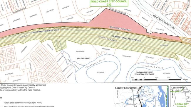
Bonney MP Sam O’Connor on his Facebook page has released a new corridor map which shows the proposed highway has moved further east, close to a 1500 apartment project worth up to $1 billion and a 25-block housing development.
SUBSCRIBE TO THE GOLD COAST BULLETIN - JUST $1 FOR THE FIRST 28 DAYS
The mapping suggests some of the developer’s land will be needed, and residents, rather than seeing a promised green space, will face views of sound barriers.
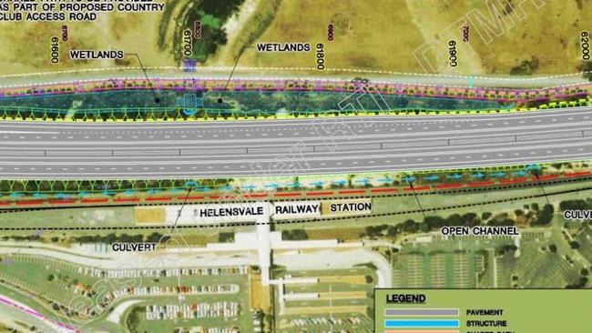
Country Club Drive at the back of the Helensvale railway station would be used for the new highway, creating problems for residents seeking access west across light and heavy rail tracks to Westfield Helensvale.
“Do you live in The Surrounds, Arundel Springs or along Greenacre Drive. You need to see these maps and take a few minutes to read this post,” Mr O’Connor writes.
“There’s no time frame for when the road will be built, the Government can’t or won’t tell us,” he said.
“It goes closer to Coombabah Creek and even takes in a section of the wetlands near Cyan Street. I think it’s a stuff up, so the Government haven’t highlighted it or even told residents.”
MORE NEWS
Mum’s heartfelt tribute to boy who passed away at age of 12
Major breakthrough in murder of Coast nurse
Big delays after car collides with cyclist
Mr O’Connor told The Bulletin the Government should have spoken to residents two years ago.
“They planned the light rail in 2015. They released the maps for the Coomera Connector in 2016 and 2017, but they didn’t update the map to include light rail,” he said.
“They updated the gazettal last week. Why didn’t they do this two years ago? Why aren’t the residents being contacted?”
Some residents who have bought luxury properties have vented on the MP’s Facebook page.
“I wouldn’t have bought a property in The Surrounds if I knew this. This is very upsetting and we feel cheated,” a resident wrote.
CASH INJECTION FOR COAST’S STRUGGLING ROADS
Another resident in a response said: “I will be heartbroken if they take yet more areas for wildlife away, it’s decreasing rapidly in the area. Koalas particularly are under pressure on the Gold Coast and at the rate we are destroying habitat and segmenting them, they will be gone soon.”
Transport Minister Mark Bailey on Friday night fired back at the criticism.
“This is an attempt by Sam O’Connor to mislead the Gold Coast community. When the southern Coomera Connector was gazetted by the department two years ago they consulted extensively with the community,’’ he said.
“Mr O’Connor would also know they consulted again with locals when the completed corridor was gazetted earlier this year.
“It’s incredible to see Mr O’Connor raising these objections when his own LNP backflipped and now support the Coomera Connector after they blocked it under Campbell Newman.
“A number of steps still need to happen in the planning for the project, including design of a preferred route through the corridor we’ve preserved, necessary studies to minimise possible environmental impacts, and the development of a business case.”
Bemused MP’s slapdown for council on parking fines
A Gold Coast MP has questioned why council is writing to the state to get parking rules relaxed – claiming legislation not only allows them to do so, but councils including Logan already take advantage. Watch the video of how Logan do it.
WATCH: Man tasered following alleged Surfers Paradise brawl
A man has allegedly jumped into a bull shark riddled river on the Gold Coast to escape police following an alleged brawl. See the video of his arrest.