
Wild weather: flash floods across South Australia as storms lash state
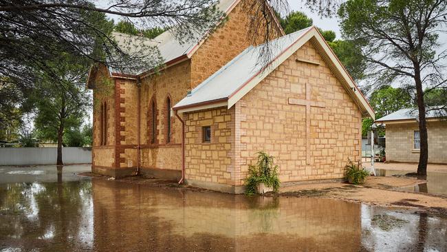
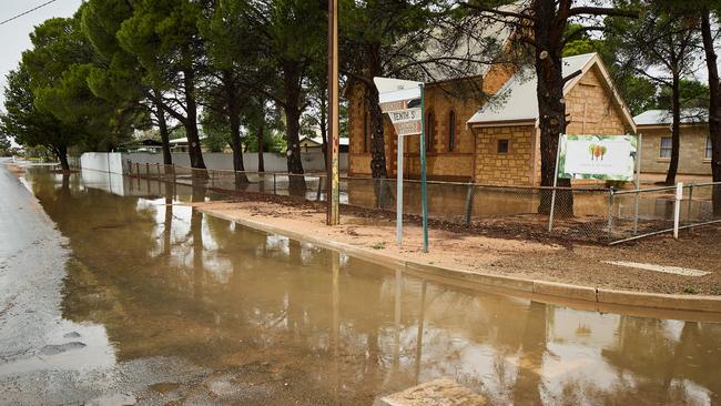
Multiple towns across the Mid-North and Riverland are on flood-watch, with roads closed and warnings of heavy intense rainfall that could cause flash flooding.
SA News
Don't miss out on the headlines from SA News. Followed categories will be added to My News.
Heavy rainfall on Sunday has triggered flashing flooding, road closures and warnings of rising rivers – with more rain coming.
Rivers and creeks are rising across the Light, Wakefield, and Gilbert river areas, in SA’s Mid-North, as well as Renmark and Berri in the Riverland, the Bureau of Meterology warned late on Sunday.
The State Emergency Service on Sunday responded to more than 70 emergency calls.
Between 40-60mm of rain fell in the areas in the 24 hours to 9am Sunday, with a severe weather warning current for parts of the catchment and more rain coming.
Elevated river levels are occurring along the Light and Gilbert Rivers, affecting areas including Saddleworth and Stockport while parts of the Wakefield River are rising.
“Very dangerous thunderstorms” likely to produce intense rainfall and potential flash flooding also sparked a flood watch and act warning in Berri and Renmark.
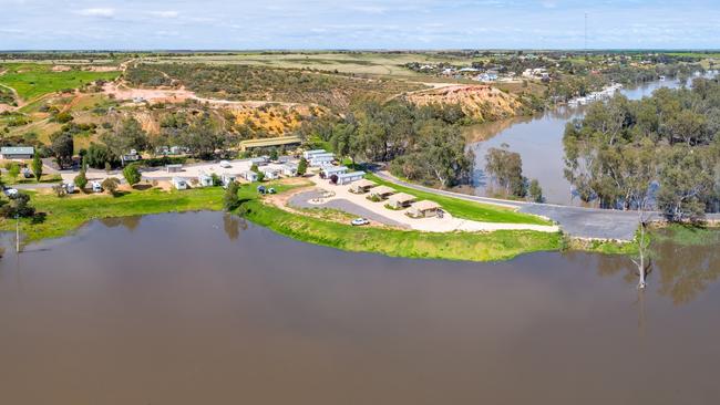
Residents, already under threat of the worst flooding in more than 50 years along the River Murray, were warned to leave if safe to do so.
#FLOOD Watch and Act MESSAGE issued for Renmark and Berri. If you are in this area you should prepare for flooding. Move valuables to a safe place. Consider going to a safer place if the path is clear. More info: https://t.co/RHRBjd60kJ ID:367/2
— SASES (@SA_SES) October 23, 2022
There are severe weather warnings for heavy rainfall for the Murraylands, Upper South-East and parts of Riverland, Lower South-East and North-East Pastoral districts.
And severe thunderstorm warnings are current for intense rainfall for parts of the Riverland district.
SA Police said multiple roads in Riverland, Mid North, Clare Valley, and Barossa were closed.
Severe Weather Warning for HEAVY RAINFALL
— Country Fire Service (@CFSAlerts) October 23, 2022
For Murraylands, Upper SE and parts of Riverland, Lower SE and North East Pastoral districts.
Issued at 4:57 pm Sun 23 Oct 2022
The next Severe Weather Warning will be issued by 11:00 pm ACDT Sun. refer https://t.co/GMoIW668cVpic.twitter.com/wTCBUriQ3y
Earlier on Sunday, the State Emergency Service issued emergency flood alerts for Stockport, 82km north of Adelaide, and for the nearby Light and Gilbert Rivers.
Officials warned residents to move their valuables to a safe place and consider leaving “if the path is clear”.
.@BOM_SA has issued a Severe Thunderstorm Warning â›ˆï¸ for INTENSE RAINFALL ðŸŒ§ï¸ For people in parts of Riverland district.
— SASES (@SA_SES) October 23, 2022
Issued 5:20pm 23 Oct 22
INTENSE RAINFALL FALLING AROUND RENMARK & BERRIhttps://t.co/CbbJmPbCDxpic.twitter.com/JkguYg7JvO
Take care on the Barrier Highway with minor flooding in parts between Peterborough and Cockburn https://t.co/VZ8nXhr1yz@DFIT_SApic.twitter.com/fXuYUneE3z
— South Australia Police (@SAPoliceNews) October 23, 2022
The wild storms sweeping the state on Sunday triggered flash flooding and some major road closures – many in the state’s outback.
Authorities earlier issued a severe weather alert on Sunday morning over concerns of heavy rain of up to 60mm across the Mid North, Riverland and Murraylands areas.
Adjacent parts of the Mount Lofty Ranges and North East Pastoral districts were also hit.
Government forecasters warned an upper-trough moving across the state was “leading to heavy rainfall in a very moist environment”.
The BOM said locations of concern also included Renmark, Clare, Murray Bridge, Gawler, Lameroo and Jamestown.
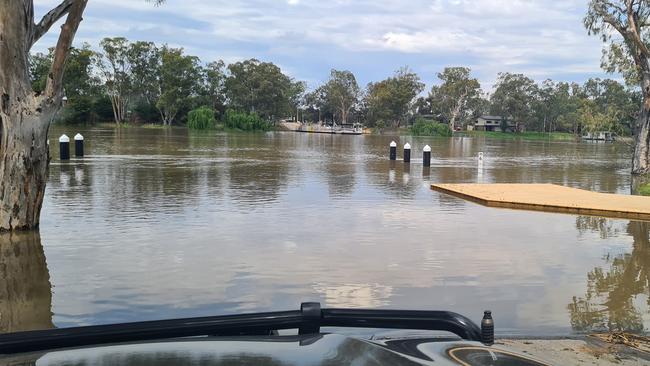
Authorities downplayed concerns the storms would increase River Murray water levels amid fears of a once in-a-half-a-century flood.
The SES had 42 requests for help on Sunday while country fire crews rescued a stranded motorist from a flooded Robertstown road, almost 60km southeast of Clare.
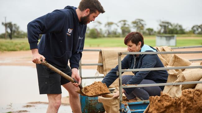
The torrential rain, and lightning storm risks also forced the SES to cancel a Riverland “sandbagging event” at Blanchetown and Morgan on Sunday.
“Heavy rainfall has occurred at both event locations, with further heavy rainfall forecast,” an SES spokesman said.
“This has made the event locations unsafe for community and emergency services personnel alike. Empty sandbags remain available at both the Blanchetown and Morgan locations.”
But it didn’t stop shack owners in Morgan from filling their own sandbags at the local football oval.
Alongside his parents, Stefan Noto said he was preparing their shack before roads made it inaccessible.
“With the way the rain is, we think those roads might get closed very shortly,” he said.
“So we’re just here filling up a few sandbags to help us and our neighbours.”
Just outside of Morgan, Mt Mary Hotel owner Donna Manders put out a call for assistance out of fear of rising floodwaters adjacent to the property.
Ms Manders said she had been overwhelmed with the community response as volunteers rolled up to help sandbag on Sunday morning.
“We have been inundated with help, we’ve been having trouble getting sand and sandbags, so it was just great to have the community put their hand out to assist us,” she said.
“There’s no lives threatened here, but there is infrastructure and our hotel plays a key role for residents in this region.”
She said rising floodwaters on the Thiele Hwy was threatening to cut off access to the hotel.
“We’ve just had unprecedented rainfall, it’s been storm cell after storm cell,” she said.
“We will remain open for as long as we can.”
#FLOOD Watch and Act MESSAGE issued for Stockport. If you are in this area you should prepare for flooding. Move valuables to a safe place. Consider going to a safer place if the path is clear. More info: https://t.co/Ptpa6cdCGL ID:365/1
— SASES (@SA_SES) October 23, 2022
He said pods with sandbags with no sand or assistance were available at the Renmark, Berri and Waikerie SES units.
A Transport Department spokesman said the flooding had closed the Barrier Highway at Manoora, 122km north of Adelaide.
A Traffic SA map had flooding alerts also along the Worlds End Highway near the Goyder Hwy, at Baldina and further south near Emmaus Rd, Eudunda.
A police spokesman urged motorists to exercise caution.
#FLOOD Advice MESSAGE issued for . If you are in this area you should prepare for flooding. Move valuables to a safe place and, if safe to do so, clear drains and gutters. More info: https://t.co/zY6Q7wgAHY ID:364/1
— SASES (@SA_SES) October 23, 2022
“There are numerous storms and flooding throughout the above areas including Bower, Penwortham, Marrabel, Clare and Manoora,” he said.
“Please drive with caution throughout flood-prone areas and report any incident of flooding via 132 500.”
A BOM spokesman warned the heavy rainfall may spark flash flooding.
He said a low-pressure system over SA, near the NSW and Queensland borders, had mixed with a high-pressure system from New Zealand to create humid tropical air across eastern Australia.
“This pattern is moving slowly, bringing showers, rain and thunderstorms,” he said.
“The weather is likely to become more settled midweek.”
He said between 30 to 50mm are likely over six hours with localised falls of up to 60mm possible, particularly with embedded thunderstorms.
Over the next 24 hours between 40 to 60mm was forecast with localised falls of up to 100mm possible “especially with embedded thunderstorms”.
He said Cooinda, near Swan Reach, had recorded 49.4mm by 11am, Mt Mary, near Morgan, 46.2mm and Claire 41.8mm.
The SES urged people not to drive, ride or walk through flood water, keep clear of creeks and storm drains as well as stay indoors and away from windows during severe conditions.
More Coverage


Originally published as Wild weather: flash floods across South Australia as storms lash state
Join the conversation

Watch: Terrifying moment racer rolls in horror crash at The Bend
A young driver’s campaign to return to racing has struck a chord with fans after a terrifying on-track moment at The Bend.
Read more

Family grocers hid kilos of opium in ‘cough and cold’ bottles
An Indian grocery and takeaway in Adelaide’s suburbs was selling much more than food, a judge says – with their illicit products now exposed.
Read more