
A tiny outback town Innamincka remains cut off as floodwaters reach 14.4m and more water is on the way
A bush pilot has likened floodwaters in South Australia’s far north to an ‘inland tsunami’, with buildings completely submerged as the deluge moves south.


SA News
Don't miss out on the headlines from SA News. Followed categories will be added to My News.
An “inland tsunami” is making its way from a tiny South Australian outback town towards Lake Eyre where it’s tipped to create an environmental oasis.
Bush pilot Trevor Wright has been flying over the state’s far north for more than 30 years and said “the flood is probably the fastest and most spread out I’ve seen”.
“Until you physically see the velocity and sheer volume of it and how it’s taking everything in it’s wake, you don’t really get a good judge of it,” Mr Wright, of Wrightsair, said.
“Normally, floods just follow the creeks around, but this one is opening up everything in it’s progress – that’s why I call it an inland tsunami.”
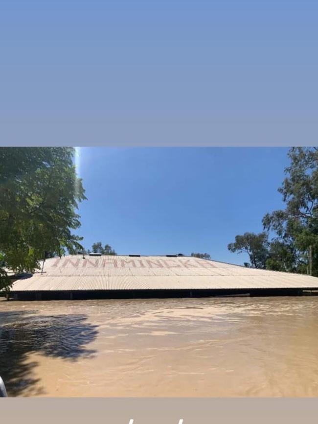
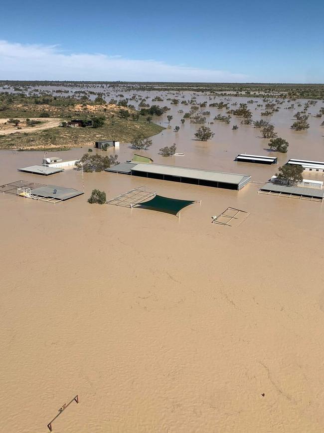
The floodwaters are surrounding Innamincka, 1000km north of Adelaide and 30km from the Queensland border, and on Thursday broke the previous record by nearly 3m.
Photos by Jacob Hutteroth from Innamincka Station, about 4km northeast of the township, show only the top of the homestead and outbuildings as visible.
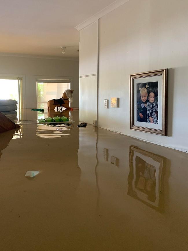
The floodwaters have flowed south from western Queensland along the Cooper Creek, with town’s residents being told they could remain cut-off for weeks.
The town has been surrounded by a DefenCell flood mitigation wall – the same used to protect communities during the River Murray floods.
The waters have reached a record high of 14.4m, but the SES warns further flood peaks were expected as water continues to flow into SA.

Cooper Creek homestay operator Ali Matthews said the town was remaining positive.
“We’re feeling pretty amazed to live through this flood event, it’s a historical event but I’d like to acknowledge there’s people that have had it worse than us,” Ms Matthews said.
“We’ve had a bit of luxury to prepare, but it wasn’t like that for our Queensland neighbours where it was torrential rain.”
While the water is expected to take a few weeks to reach Lake Eyre, Mr Wright said there would be “three high velocity” water systems coming into the lake at one time.
“For tourism, this will be fantastic but there also has to be a balance because some of these people have suffered an immense loss in terms of stock and infrastructure,” he said.
“Environmentally, it will definitely spur along breeding cycles of birds and when the lake is full, it’s like an inland sea and I reckon this is one of the occasions you’ll be able to see it.”
Santos has committed $500,000 to help flood-affected communities and has used its helicopters to deliver food, hay bales, fuel supplies and to evacuate residents.
Chief executive Kevin Gallagher said its modelling showed there was “no threat at this point” to its Moomba gas operations and airfield.
“Historically, Mooba has always been well protected, I believe, during the 2010, 1990 and 1974 (floods) so I think we’re pretty, pretty comfortable with that aspect,” Mr Gallagher said.

The floodwaters have broken the previous record of 11.8m in 1974.
The Strzelecki Track is closed and is impassable east of Moomba.
The SES advises the waters are expected to cut off the Strzelecki Track, near Riecks Rd in the next day or so, and flow towards Lake Blanche.
More Coverage


Originally published as A tiny outback town Innamincka remains cut off as floodwaters reach 14.4m and more water is on the way
Join the conversation

‘Very dangerous’ monster 4m shark spotted in SA shallows
Even more chilling vision has emerged of sharks just metres off SA beaches as the unusually high amount of sightings continue across the state. Video: Shark Watch SA/Joe V
Read more

Anzac Day dawn services unite South Aussies to honour the fallen
South Australians have gathered for moving Anzac Day dawn services to remember the high cost paid by those who have fought in conflicts across the globe.
Read more