
Adelaide Hills on flooding alert as Coromandel Valley road, Oakbank bridge closed
Heavy rains will continue overnight and into Friday across SA, with rivers and creeks rising in the Hills, closing roads and flooding bridges.

SA News
Don't miss out on the headlines from SA News. Followed categories will be added to My News.
Torrential rain has resulted in flooding, with one road in the Adelaide Hills being closed off to traffic.
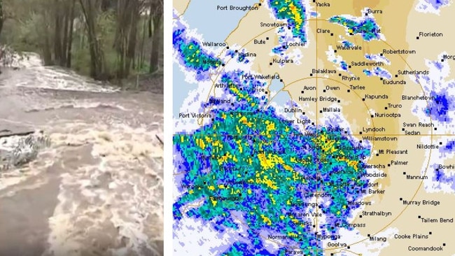
Winns Rd at Coromandel Valley has been closed by police due to excessive flood waters.
And there are minor flood warnings for the upper Onkaparinga River at Oakbank, which has been hit by up to 35mm in the past day or so.
The Bureau of Meteorology warns more significant rainfall is forecast for the area overnight.
The river at Oakbank was 0.64m at 2pm on Thursday, but is expected to hit 2.10m by Thursday night.
State Emergency Services were called to several homes across Adelaide on Thursday night after reports of flooding and weather damage.
South Australia is being hit with a major winter downpour from a 350km-wide rain band, and the showers will last for days.
Tom Ramage, metrologist from the Bureau of Meteorology, said the wet weather will continue to hit Adelaide tomorrow before easing throughout the day.
A total of 2 to 7mm are expected to fall, with a small reprieve before another rainband hits on Saturday.
“There will be a series of cold fronts moving across from Western Australia and bringing moisture,” Mr Ramage explained.
HAPPENING NOW: Floodwaters have forced the closure of the Winns Road ford at Coromandel Valley. Send your weather videos to 7NEWS: https://t.co/xdDzDd1frA The latest in 7NEWS Adelaide at 6pm | https://t.co/8ftPfGh39Y#7NEWSpic.twitter.com/rnGGGufg8S
— 7NEWS Adelaide (@7NewsAdelaide) June 22, 2023
As of 11am Thursday, Adelaide had recorded 7.6mm of rain in the two hours since 9am with up to 25mm forecast across the day. The morning temperature had reached just 9.7C with a forecast maximum of just 13C.
Adelaide Airport recorded 5.6mm of rain from 9-11am, with a maximum temperature of 3.8C, while Mt Lofty had 4.6mm of rain in that time with a maximum temperature of 6.1C.
There’s the chance of a thunderstorm during the morning and afternoon in the metropolitan area, and winds north-easterly 15-25km/h turning north-westerly 25-35 km/h in the middle of the day.
The Bureau of Meteorology forecasts that scattered showers will persist until Wednesday, with maximum temperatures around 15-16C all week.
Minimum temperatures will drop to 9C on Friday, with a high chance of showers (2-6mm), most likely in the morning.
The forecast is similar across the metropolitan area, with even cooler temperatures in the outer suburbs and Adelaide Hills. Stirling is forecast to have a maximum of just 9C today and 10-11C over the weekend.
Steady rainfall across the Hills is causing traffic chaos on the freeway and delays within towns. Multiple crashes on the freeway forced huge numbers of cars to travel through Hills towns, adding to traffic build-up.
Creeks and rivers are rising after strong falls overnight – Mount Lofty was hit with 11.4mm to 9am on Thursday.
ADELAIDE RAIN RADAR
The rain started on Thursday morning amid cold conditions, with Mount Barker receiving 5mm since 9am and a high of 7.5C.
Mount Lofty has had 4.6mm since 9am.
In Lower Eyre Peninsula, the Bureau has forecasted a high chance of rain, and a thunderstorms during the morning and afternoon, as maximum temperatures top 14C.
In SA’s South-East, there will still be rain but probably not as much as areas around Adelaide, while the overnight temperature will dip to 5C tonight in Mount Gambier.
WEATHER FORECASTER: HIT PLAY BUTTON
SA has been hit with “above average” rainfall so far this month despite long-range forecasts suggesting a drier and slightly warmer than usual winter was in store.
Over the past fortnight the state has seen a period of “very winter-like conditions” after the warmest start to June since 1957.
Last weekend, the State Emergency Service received calls of 61 incidents. Many were from storm water leaking into houses and fallen tree branches.
More Coverage


Originally published as Adelaide Hills on flooding alert as Coromandel Valley road, Oakbank bridge closed

Australian Almonds brings the star power for global push
Australian almond growers are eyeing new overseas markets as exports boom and their board has appointed celebrity chef Poh as its first global ambassador.
Read more

Prominent GP resigns: Who is Dr Taylor?
A prominent South East GP has resigned after restrictions were placed on his registration – but who is Dr Jeffrey Taylor?
Read more