
Gold Coast weather: More than 300mm on Gold Coast, causing dangerous flooding
More than triple the Gold Coast’s average monthly rainfall hit the city in just 12 hours in an epic downpour which saw houses and roads flooded.
Gold Coast
Don't miss out on the headlines from Gold Coast. Followed categories will be added to My News.
MORE than triple the Gold Coast’s average monthly rainfall hit the city in just 12 hours in an epic downpour which saw houses and roads flooded.
The city was smashed by torrential rain that has caused dangerous and life-threatening flash flooding, beginning late last night.
Carrara received the heaviest rainfall, with 299mm recorded.
Two people have been rushed to hospital after a tree fell on their car on the corner of Currumbin Creek Rd and Steward Rd at Currumbin about 9.30am this morning.
Paramedics rushed the pair to hospital in a stable condition.
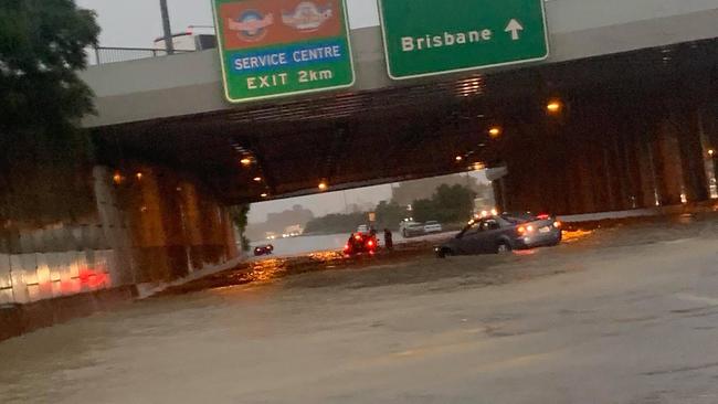
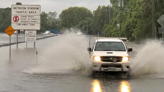
The M1 was closed for more than six hours before finally reopening early this afternoon.
However, Gold Coasters are being warned to keep an eye on weather forecasts with a possibility of more heavy rain this afternoon.
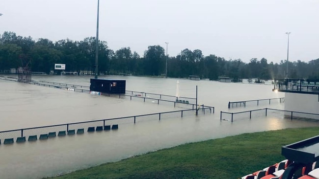
RAIN WRECKED HAVOC ON COAST SPORTING FIXTURES
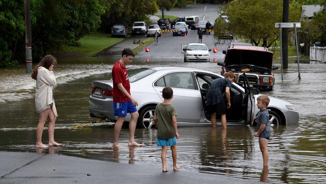
Streets across the Gold Coast were flooded out as emergency services perform swift water rescues following the 300mm rain super cell which fell on the city overnight.
Loders Creek was heavily flooded as the rain overloaded the waterway.
Footage shot by Southport resident Kelly Glover early this morning showed a man rowing a tinnie down the centre of Baratta Street.

Weather Bureau forecaster Peter Markwith said there was a “decent chance” of more rainfall today.
“The mechanism of the trough is still in the area,” he said.
“There is a chance heavy rainfall is possible.”
Mr Markwith advised residents to keep an eye on weather warnings and forecasts coming through this afternoon.
Heavy rain is expected to clear by tomorrow but shows will stay in the area.
Mr Markwith said there is a 90 per cent chance of between 10 to 35mm falling on the Gold Coast tomorrow.
The M1 is still closed in both directions at Oxenford, but police are starting to let trucks through. https://t.co/VZ3A1cpmr5 #qldtraffic #7NEWS pic.twitter.com/4Zy6yRBRO9
— 7NEWS Brisbane (@7NewsBrisbane) January 17, 2020
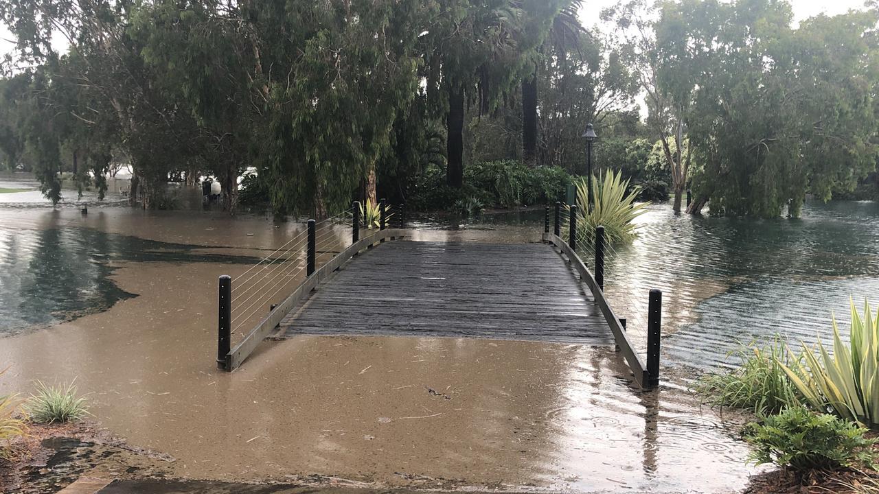
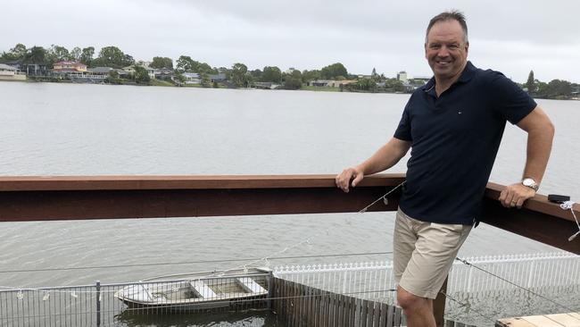
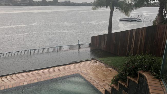
The gardens of homes in Burleigh Waters’ Dipper Drive, which front Lake Heron remained flooded early this afternoon.
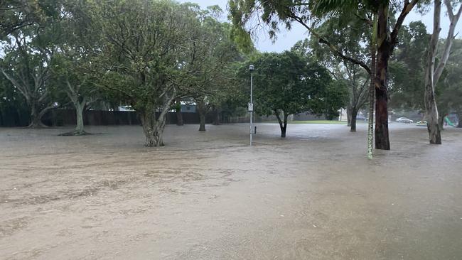
Gardens of waterfront homes were submerged in the deluge and playground equipment at Galeen Drive Park, next to the lake, also went under.
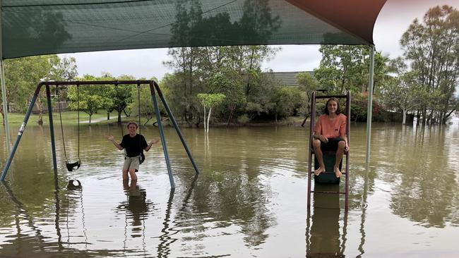
Burleigh residents Jack Steele, 16, and Bailey Harasymenko, 15, have lived in the area for more than 10 years and they said the last time they saw the park underwater was in 2017.
“This playground is usually covered in grass and wood chips. Now, there’s water everywhere,” Jack, a student at All Saints Lutheran College, said.
He and other residents said the water level of the lake had risen by 1.5m during the downpour.
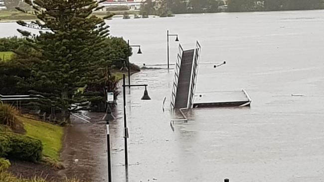
At nearby Varsity Lakes, the weir at Bond University in Lake Orr was also flooded as water raged through it.
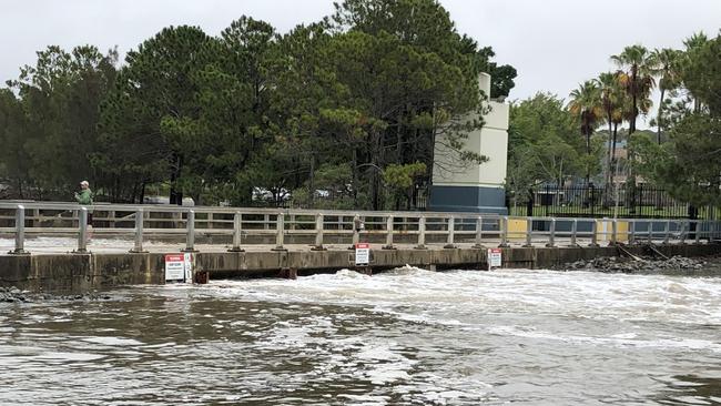
A local resident, who did not want to be named, said he had lived in the area for 10 years and had never seen anything like it.
“The water that flooded through the weir was knee deep. It was amazing,” he said.
The weir, which is used as a popular thoroughfare to the university, was almost impassable on Saturday and showed little sign of abating.
Meanwhile, residents gathered opposite Blackboard coffee shop in Varsity Parade to view the impact of the heavy rains on Lake Orr.
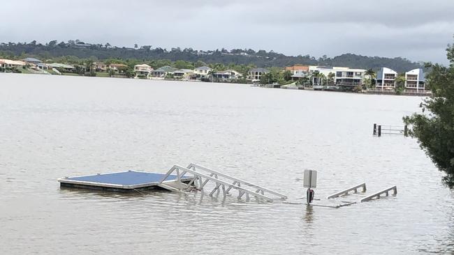
A nearby pontoon was spotted half submerged and debris had been washed on to the usually pristine beach.
Dipper Drive resident Steve Ross said water had flooded half his back yard, reaching half the height of his fence.
However, he was confident it would subside soon.
He said the water level had risen by about 1.5m at 7am today but it had dropped by half a metre by 1pm.
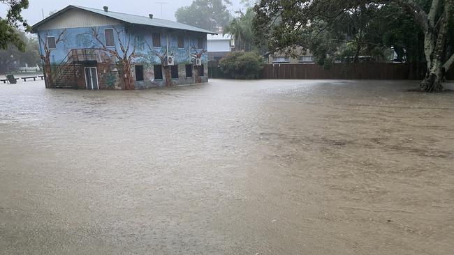
Luke Altschwager owner of Parkwood Village said the flooding and creek near Napper Road was going over the road and described it as a “one in 100 year” occurrence.
“I have not seen it like this before. But the rain is nice and it is needed,” he said.
“The golf course is under and the village is shut for safety.”
In a statement issued at 10am this morning, the Gold Coast City Council said the severe weather situation was easing.
“Following heavy rain overnight the severe weather situation is now easing,” the statement said.
“Water within the City of Gold Coast catchment areas is receding and does not pose a threat to the community. Dam levels will continue to be monitored.
“Some roads have been experiencing flooding, however roads are now clearing.
“There are some instances of minor damage to infrastructure across the city which is being attended to by city maintenance crews and key partners.”
The overnight rain has had little effect on dam levels in the south east corner.
At 9am this morning levels were at 56 per cent – compared to 55.3 per cent on Friday.
Emergency services urged Gold Coasters to stay off the roads.
Tram services were suspended because of flooding through Southport but as of 8.20am, the light rail is again operating.
However passengers have been warned of delays of up to 10 minutes.
G:link services have resumed in both directions between GCUH and Southport stations following earlier flooding near Queen Street station. Trams are now servicing all stations. Customers can expect delays of up to 10 minutes. https://t.co/dwfq1vPZ31 #TLAlert #Glink #ridetheg pic.twitter.com/mnOidnx2aa
— TransLink (@TransLinkSEQ) January 17, 2020
The worst affected areas are Coomera Shores, Carrara, and Evandale Park.
The State Emergency Service (SES) was called to more than 150 jobs across the Gold Coast in the past 12 hours.
As of 7.04am the Weather Bureau cancelled a severe storm warning for the Gold Coast region.
Between 6am and 7am more than 95mm of rain was recorded in Carrara.
The Gold Coast City Council has activated the Nerang Bicentennial Centre as a place of refuge for any residents who need to evacuate.
The Pacific Motorway has been cut in both directions at Helensvale due to flooding. Remember, if it’s #FloodedForgetIt. pic.twitter.com/1aPd6y8uQj
— RACQ (@RACQOfficial) January 17, 2020
Village Roadshow announced that Warner Bros Movie World Theme Park was closed today.
“Please be aware that due to severe weather and flooding, Warner Bros. Movie World will be closed today for the safety of our guests and team members,” the park said in a statement posted to Facebook.
Wet ‘n’ Wild, Dreamworld and WhiteWater World also closed due to the downpour.
“The safety of our guests and team is our priority,” the theme park said on their Facebook page.
“We appreciate your patience and apologise for any inconvenience caused”.

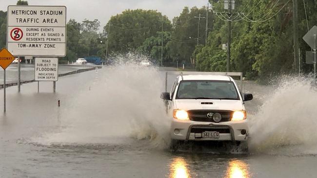
Gold Coast police said the intense rainfall and storm activity has led to dangerous and life-threatening flash flooding, which has caused 52 incidents on Gold Coast roads.
There were multiple swift water rescues.
A ute was swept away at Country Paradise Parklands on Beaudesert Nerang Road in Nerang. Flood waters were to the roofs of cars on Ferry Road in Southport.
At 8:50am there was a swift rescue on Highfield Drive in Merrimac.
KEEP UP WITH THE CONVERSATION. 50% OFF FOR THE FIRST 12 WEEKS. T & Cs APPLY
At Southport, the normally quiet Keebra Park was flooded with water, turning it into a river-like raging torrent.
“Our park has turned into a river, this is really scary,” one resident said.
More than 175 homes are without power early in the day.
There was flash flooding on Hythe Street to Kelly Ave, Miami and the road is blocked. Drivers are to proceed with caution.
Queensland Fire and Emergency Services advises that people should:
* Beware of fallen trees and powerlines.
* Never drive, walk or ride through flood waters. If it’s flooded, forget it.
* For emergency assistance contact the SES on 132 500.
ROAD AFFECTED BY FLASH FLOODING:
– Gold Coast Highway, Miami
– M1, Helensvale – both directions
– Cunningham Highway, Mount Edwards/Tregony
– Bermuda Street, Burleigh Heads
– Hardys Road, Bonogin
– Hungerford Road, Dynevor
– Baratta Street, Southport
RAINFALL TOTALS SINCE 9AM FRIDAY:
Steiglitz Wharf – 179mm
Couran Point – 179mm
South Stradbroke Island – 143mm
Coomera Shores – 215mm
Monterey Keys – 223mm
Clagiraba Road – 145mm
Clearview – 266mm
Carrara – 299mm
Evandale – 292mm
Worongary Creek – 246mm
Burleigh Waters – 285mm
Tallebudgera Creek – 220mm
Mudgeeraba – 232mm
Neranwood – 203mm
Tallebudgera Creek Road – 239mm
Coolangatta – 200mm

Leadfoot lawyer in hot water for failing to disclose dire traffic record
A Gold Coast lawyer has been fined and publicly reprimanded for omitting to tell the Queensland Law Society about a series of traffic-related matters he was required to disclose.

Hobbiton, glow-worm caves: New direct flight from the Gold Coast
Australian airline passengers, from a popular international destination, have touched down on the Gold Coast for the first time in years amid confidence in a foreign flights bounce back.