How the Surfers oceanway will face flood, safety risks
Consultants have identified at least eight major risks in council proceeding with the $6 million-plus Surfers south oceanway, warning a fatality could occur in construction.
Gold Coast
Don't miss out on the headlines from Gold Coast. Followed categories will be added to My News.
GOLD Coast City Council consultants have identified eight major risks in extending the controversial oceanway south of Surfers Paradise, including the potential for death during construction.
A private report from consultants SMEC shows the risks are due to the 4m-wide concrete pathway being built on a decades-old seawall that no one knows the exact location of.
Eight of 12 risks identified by the consultants were rated nine out of 10. A safety-in-design register warns there is a high risk of injury or death to workers because machinery might be overturned.

FULL DIGITAL ACCESS: JUST $1 FOR FIRST 28 DAYS
The key warnings from consultants to council about the $6m, a 1.6km-long path include:
● Identifying the impact on existing underground and overhead utility services. Some will need to be relocated.
● The oceanway structure could fail due to poor and inappropriate materials being used.
● The potential for the “degradation of the existing sea wall and premature failure of the oceanway”.
● Scour and erosion during construction leading to environmental damage.
Other concerns included excessive noise and the potential, if suitable materials could not be found, for delays to the project.

The Surfers Beachfront Protection Association (SBPA) has filed an application in the Planning and Environment Court to overturn the approval of the concrete path.
The extension of the Oceanway has been a long-running issue, with plans for new sections proving highly controversial in some neighbourhoods. The path runs from The Spit to Surfers Paradise, and then from Currumbin to the border. Sections in between have been debated for nearly 15 years.
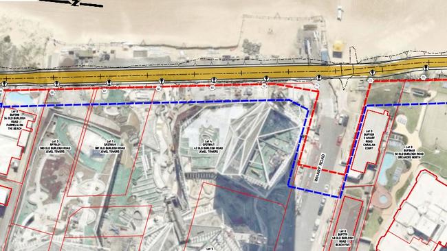
The report notes the Surfers south site — between Laycock Street in Surfers Paradise and First Avenue, Broadbeach — is located in a narrow corridor between property boundaries and foredunes.
“Minimising disruption to local residents and beach users is a significant consideration as part of the construction operations for the project,” the consultants said.
Site constraints prompted consultants to set specific guidelines for council in employing a future construction team.
“The project is located in a sensitive environment,” the report says. “All waste material must be removed from the site immediately to prevent it being buried by sand or making its way to the ocean.

“Existing private property accesses onto the beach will be directly impacted by the works. Disturbance to the environmentally sensitive dune area is likely to leave it prone to erosion if not revegetated promptly. Temporary closure of public beach accesses will be required.”
But the bigger concerns surround the approved foreshore seawall alignment or A-line established in 1976 where residents have spent large amounts of money creating a buffer to stop beach erosion and protect their properties.
“The condition and profile of the seawall along much of the project corridor is unknown leading to potential damage or settlement issues,” consultants said.

“The profile of the seawall is relatively unknown. Interaction with pavement profile, light pole footings and drainage to be reconstructed is unknown.
“Condition of the existing seawall is unverified in most locations along the alignment and has the potential for voids to be present which may collapse.”
Land acquisitions would not be required and most works should not have to be conducted within private properties.
“Although there may be potential for interaction with the private properties neighbouring the site. This will need to be managed between stakeholders and the contractor,” the consultants said.

Consultants predict construction will take at least 16 weeks and cost about $5.33m, which does not cover a contingency allowance of 10 per cent.
They concluded the oceanway could be “practically implemented and constructed” and would improve the area for cyclists and pedestrians.
Council has declined to comment because of ongoing legal action launched by residents.
FIVE ISSUES RAISED BY OBJECTORS
COUNCILLORS have been warned the $6 million Surfers south oceanway could cause serious environmental harm and impact on seawalls leading to a potential failure.
The Bulletin has obtained a lengthy email from the Surfers Beachfront Protections Associations Inc which asks the council to stop construction and approval of the development permit. It has taken the council and state government to the Planning and Environment Court to overturn the approval of the 1.6km-long concrete path.

Council ticked off on the next stage of the oceanway in 2019, but it stalled this month when beachfront residents took legal action.
In the private letter to councillors, residents said:
● The development permit will involve “removing or interfering with coastal dunes or land other than State coastal land in an erosion prone area”.
● Those works fail to comply and “will cause or likely cause serious or material environmental harm”.
● A business study was not conducted despite council possibly spending more than $6.5m.
● Detailed studies have not been produced showing a need for “recreational infrastructure”.
● The approved plans show extensive cuts and fill to the dunal system around the A-line protective boulder wall.

WATCH THE VIDEO: MAN’S ‘NUMBER OF BLOWS’ IN TERRIFYING SURFERS STREET BRAWL
The association warned damage to the seawall could lead to the “premature failure of the oceanway”.
The seawall alignment was created in 1976 after serious weather events, and any structures located seaward were considered sacrificial.
“Private residents who remain liable for any maintenance or repair to seawalls constructed at their cost do not wish to incur additional costs which may arise from coastal erosion or damage due to the breaking up of the concrete pathway,” the association said.

Council was aware the oceanway may need to be sacrificed in a major weather event, yet still wanted residents to be liable for maintenance of the seawalls, the association added.
The group accused council of not undertaking extensive consultation and their concerns were often “ignored” by officers.
The Bulletin understands the council wanted to start work on the 4m-wide path between Laycock Street in Surfers Paradise and First Avenue, Broadbeach on April 27 but that has been delayed until a directions hearing in the court three days later.

FULL DIGITAL ACCESS: JUST $1 FOR FIRST 28 DAYS
A consultant report to council has warned existing private property accesses onto the beach would be directly impacted by the works.
“Disturbance to the environmentally sensitive dune area is likely to leave it prone to erosion if not revegetated promptly,” the report said.

Temporary closure of public beach accesses will be required during construction.
The Bulletin has approached council for comment on the risks outlined by consultants, the costs and timing of works.
But a city spokesperson said: “As this matter is before the courts, the city is unable to comment at this time.”
EARLIER: THREAT FROM MAJOR WEATHER EVENT
MAPPING in a confidential report by consultants shows how a section of the planned Surfers south oceanway will be under threat from a major weather event.
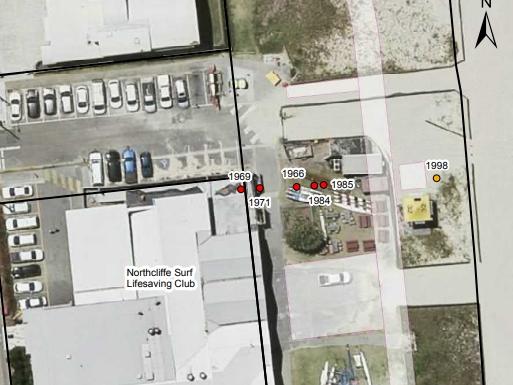
The map produced in a lengthy report to council by SMEC consultants focuses on the challenge of building a section of the oceanway at the front of the Northcliffe Surf Life Saving Club.

An aerial shot reveals five historic flooding events at the clubhouse — in 1966, 1968, 1971, 1984 and 1985 — and markers where areas were lost, all of them west of where the planned oceanway is to be built.
Even after beaches were built up in the 1990s, the section near the existing lifeguard tower was “at threat”.
This area is just forward of where the planned 4m-wide pathway will be built.
Original planning documents showed an offset of 23m from the clubhouse for the proposed path, but after concerns from clubbies and discussions with authorities consultants undertook a review and set it at 9.5m.

They predict the new boundary was more likely to withstand damage from the three erosion events in 1984, 1985 and 1998.
Council had improved beach nourishment since the succession of storm events in the 1960s and 1970s, consultants said.
But they warned there was no guarantee that severe coastal erosion would not occur up to the A-line seawall in the future.

The 9.5m buffer between the path and the club is considered enough to allow for storage of vehicles and lifesaving gear.
“The oceanway has been placed landward of the proposed turfed and landscaped areas to ensure the space is not unnecessarily confined and views and access to the beach are maintained,” consultants wrote.

“While it is not feasible to place the oceanway landward of the A-Line at Northcliffe SLSC, the current alignment of the oceanway and associated infrastructure ensures that the risk of damage due to coastal erosion is reduced as far as possible,” the report said.
“It is anticipated that these design elements in unison with the operational strategies to be considered by the Northcliffe SLSC will allow the community benefits of the oceanway to be realised.”

Council declines to comment as it is in a legal dispute with residents about the pathway.


