
M1 closed at Tugun: Full list of flooded Gold Coast roads
SEE the full list of Gold Coast roads closed due to flooding.
Gold Coast
Don't miss out on the headlines from Gold Coast. Followed categories will be added to My News.
POLICE have closed the M1 at Tugun near Exit 95 due to flooding.
No further southbound traffic will be allowed until further notice, with the Tugun Bypass closed at Stewart Road due to flooding at Chinderah.
The M1 is also closed in both directions between the Tweed Heads exit and Tweed Valley Way at Chinderah due to floodwaters.
Motorists are advised to avoid the area, with lengthy delays expected during the busy Friday afternoon commute.
Queensland Police are discouraging travel to NSW due to significant flooding in the area.
“A number of roads in the Kingscliff, Chinderah, Tweed South and Tweed Heads areas have become congested with vehicles and there are concerns motorists attempting to flee may become trapped in rising flood waters,” NSW Police said in a statement.
Motorists wishing to access Gold Coast airport are advised to exit the M1 at Stewart Road and take the Gold Coast Highway.
Gold Coast Police said south bound motorists using the diversion are not able to travel beyond Minjungbal Drive, Tweed Heads.
The M1 southbound on-ramp near Robina Town Centre Drive is open again and a hazard on the southband lanes of the M1 at Yatala has cleared.
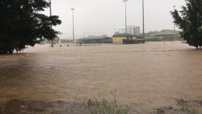
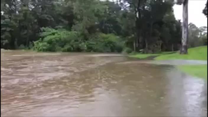
The motorway is one of dozens of roads across the Gold Coast that remain flooded after a second night of heavy rain that has seen nearly 800mm dumped across some parts of the city in two days.
Almost all major arterial roads on the Coast have been affected.
The Gold Coast Highway is also cut at Tugun, Burleigh Heads and Coombabah.
ROLLING COVERAGE: WILD WINDS LASH CITY
GOLD COAST ROAD CLOSURES
-Tugun Bypass, Tugun, Tugun Bypass closed at Stewart due to flooding at Chindrah.
-Pacific Motorway, Yatala, Exit 38, Both Exits Flooded
-Pacific Motorway, Robina, Exit 80 Mudgeeraba
-Pacific Motorway, Banora Point / Tugun, Tugun Bypass closed at Stewart due to flooding at Chindrah.
-Gold Coast Highway, Burleigh Heads, intersection of Christine Ave
-Gold Coast Highway, Burleigh Heads, water on Road at Ikkina Road
-Gold Coast Highway, Coombabah, between Country Club Drive and Marble Arch
-Old Pacific Highway, Yatala, water on Road between Elderslie Road and Lloyds Lane
-Alpine Terrace, Geissmann Drive, Tamborine Mountain Road, Tamborine Mountain Road (Bartle Road), Tamborine Mountain Road (Main Western Road), Tamborine Mountain Road (White Road) at Boyland / Canungra / Tamborine Mountain, from Tamborine Mountain to Canungra
-Running Creek Road, Running Creek
-Mudgeeraba Road, Mudgeeraba / Tallai, water on Road between Scullin Street and Tallai Road
-Maudsland Road, Oxenford, water on road south of Tamborine Oxenford Road
-Currumbin Creek Road, Currumbin Valley, just west of Piggabeen Road
-Beechmont Road, Clagiraba, prior Lower Beechmont Road closed at Intersection of Beechmont Road and Nerang Murwillumbah Road
-Tamborine Oxenford Road, Upper Coomera, John Muntz Causeway and Maudsland Road
-Currumbin Creek Road, Currumbin Valley, landslide - 1km west of Braewood Dr
-Pine Creek Road, Springbrook, road washed away
-Gold Coast Springbrook Road, Advancetown, fallen power lines
-Lamington National Park Road, Cainbable, land slippage - Blocking all lanes
-Gold Coast Springbrook Road, Mudgeeraba, Somerset Drive
-Nielsens Road, Carrara, between Nerang Broadbeach Road and Hickey Way
-Latimers Crossing Road, Gilston, intersection with Hinde Road is under water
-Nielsens Road, Carrara
-Tallebudgera Creek Road, Tallebudgera Valley, large landslip - complete road closure
-Nerang Murwillumbah Road, Natural Bridge, landslide near Natural Bridge turnoff Bakers Road
-Pimpama Jacobs Well Road, Pimpama, between rail overpass and Wharf Road
-Beechmont Road, Lower Beechmont, at intersection with Brushbox Road
-Worongary Road (Advancetown Mudgeeraba Road), Worongary, at Bridge Creek east of Gilston Primary School
-Tallebudgera Creek Road, Tallebudgera Valley, Tallebudgera Connection Road intersection
-Tallebudgera Connection Road, Tallebudgera, near Grays road
-Gold Coast Springbrook Road, Mudgeeraba, landslip between Tarrant Drive and Mudgeeraba Creek School
-Tomewin Mountain Road (Tomewin Currumbin Creek Road), Currumbin Valley, near Property Number 658
-Somerset Drive, Mudgeeraba, between Franklin Drive and Bonogin Road
-Lamington National Park Road (Canungra Ck Bridge), Canungra, Canungra Creek
-Mudgeeraba Road (Advancetown Mudgeeraba Road), Mudgeeraba, Near Transfer Station
-Araluen Road, Tallebudgera Valley, between Tallebudgera Creek Road and End Araluen Road
-Robina Parkway, Merrimac / Robina, between Markeri Street and Gooding Drive
-Gold Coast Springbrook Road, Mudgeeraba, between Hinterland Drive and Mclachlan Ave
-Gold Coast Springbrook Road, Neranwood, flooding - Mudgeeraba Creek
-Franklin Drive (Gold Coast Springbrook Road), Mudgeeraba, between McLachlan Avenue and Hinterland Drive
-Boowaggan Road, Merrimac, between Gooding Drive and Robina Parkway
-Olsen Avenue, Molendinar, Olsen Avenue Six-laning upgrade
-Special event, Esplanade, Surfers Paradise, Closed between Soul Round-a-bout to Hanlan Street
-Angelica Street, Elanora, water on road
-Bond University Ring Road, Robina, water over Road at Weir Bridge
-Reserve Road, Upper Coomera, water on Road between Rivendell Place and John Siganto Park
-Rivermount Drive, Yatala, between Paterson Road and Rivermount College
-Paterson Road, Yatala, between Glen Orsmond Road and Albert River
-Goldmine Road, Ormeau, water on Road under rail bridge
-Eastern Service Road, Stapylton, corner Christensen Road
-Nyholt Drive, Yatala, corner Business Street
-Gooding Drive, Carrara, open with caution between Boowaggan Rd and Robina Parkway due to minor debris from flood
-Yellowood Road, Stapylton, between Stapylton Jacobs Well Road and Quinns Hill Road West
-Ironbark Street, Elanora, water on Road between Angelica Street and Avocado Street
-Nineteenth Avenue, Elanora, water on Road between Kalmia Court and Guineas Creek Road
-Guineas Creek Road, Elanora, water on Road
-Orange Mountain Road, Ormeau, water on road
-Alabaster Drive, Carrara, between Nerang Broadbeach Road and Plateau Crescent
-Mattocks Road, Burleigh Waters, lights off - Reedy Creek road Intersection
-Rudd Street, Broadbeach Waters, fallen Tree
-Syndicate Road, Tallebudgera, road has collapsed - Closed to all vehicles
-Birmingham Road, Carrara, between Nerang Broadbeach Rd and Nielsens Rd
-Bundall Road, Surfers Paradise, Crombie Avenue
-Clagiraba Road, Mount Nathan, Clagiraba Creek
-Pimpama Jacobs Well Road, between rail overpass and Wharf Road
TWEED SHIRE ROAD CLOSURES
-Alma Street, Tweed Heads, water over road
-Bilambil Road, Tweed Shire, Road closed. Flooded road
-Chinderah Bay Drive, Chinderah, water over road
-Chinderah Road, Chinderah, water over road at roundabout
-Clothiers Creek Road, water over road
-Cobaki Road, road flooded
-Crabbes Creek Road, road flooded at Culverts.
-Kyogle Rd, closed by Yangum Bridge
-Kyogle Rd, at Sharps Road
-Kyogle Road / Smiths Creek Road, water over road
-Kyogle Road, Bray Park, water over road
-Limpinwood Road, road flooded
-Mooball-Pottsville Road, water over road at Quinns Bridge. Road Closed.
-North Arm, Closed between Wollumbin High School and Numinbah North Arm Road Intersection
-Numinbah Road, Nobbys Creek, water over road
-Palmvale Road, Palmvale, water over road
-Piggabeen Road at Cobaki Village, water over road, exercise caution.
-River Street, Chinderah, water over road
-Riverside Drive, Tumbulgum, road flooded
-Stokers Road, road closed due to rising flood water
-Terranora Road, North Tumbulgum, water over road
-Tumbulgum Road, Murwillumbah
-Tweed Valley Way, Tweed Valley closed from Condong to Pacific Highway (Chinderah)
-Tweed Valley Way, Mooball, water over road
-Tweed Valley Way/ Clothiers Creek Intersection, road flooded
-Tyalgum Road, water over road at Rocky Cutting, road closed - flooding 1km from intersection.
-Wooyung Road, water over road
-Kennedy Drive (Ducat to Gray St), water over road
-Kyogle Road, landslip and fallen tree near Shire Boundary. Open one lane, proceed with caution.
-Spring Valley Road, caution collapsed culvert near end of road. Temporary bypass bridge in place with 5 tonne weight limit.
BYRON SHIRE ROAD CLOSURES
-Argyle Street, Byron- reopened, but water still in some places
-Balemo Dr, northern and southern end closed
-Beacons Road, Byron
-Booyong Road, Bridge closed
-Coolamon Scenic Drive
-Coorabell Rd, trees over Keys Bridge
-Coopers Shoot Road, Bangalow
-Coral Avenue, Byron
-Dingo Lane
-Friday Hutt Rd
-Grays Lane, Byron
-Goonengerry Rd, trees over road
-Gulgan Rd
-Left Bank Road, Water over road from Frasers Road
-Left Bank Road, at Tuckeroo Ave
-Mafeking Rd, trees over road
-Main Arm Rd, some water in areas
-Midgen Flat Road, Byron
-Nashua Area
-Mullumbimby Road, Water over road near Uncle Tom’s Flat
-Myocum Road, at James Lane, near Myocum Downs, at Barlows Farm and near Coolamon Scenic Drive
-Orana Road, at Reka Road
-Palmwoods Road, Byron
-Repentance Creek Road, closed at causeway
-Settlement Rd, road surface damage
-Seven Mile Beach Rd, approx 2.2km from Beach Reserve Road there is a tree with powerlines in it. Please DO NOT proceed past tree
-Skinners Shoot Road, Byron
-South Golden Beach, proceed with caution
-The Pocket Road, water over causeways
-Tinderbox Road, Byron
-Tyagarah Road, Byron
-Upper Main Arm Road, Byron
-Upper Wilsons Creek Road, closed from 3 Ways
-Whian Road, Eureka
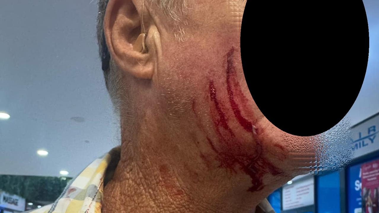
‘Pulled out small knife’: Senior attacked at GC shop centre
Shocking images have surfaced from Nerang Fair Shopping Centre where a 68-year-old man was attacked at knifepoint allegedly by a young male teen.

‘Public interest’ in bankrupting Coast lawyer
A decision is expected within weeks on whether a disgraced ex-lawyer will be bankrupted in a landmark Federal Court case. Read what happened in the hearing’s final day: