
Weather: Bureau of Meteorology forecasts another wet week for Gold Coast and southeast Qld
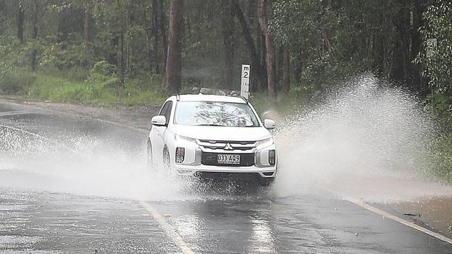
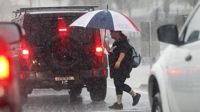
Swiftwater technicians have rescued two women from the roof of a car stuck in floodwater on the Gold Coast as showers are forecast to continue for a while yet.
Gold Coast
Don't miss out on the headlines from Gold Coast. Followed categories will be added to My News.
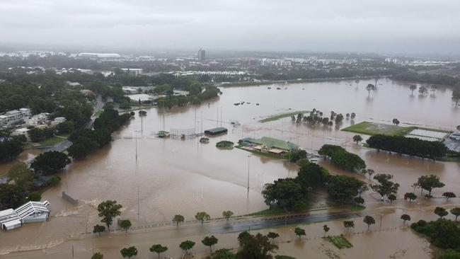
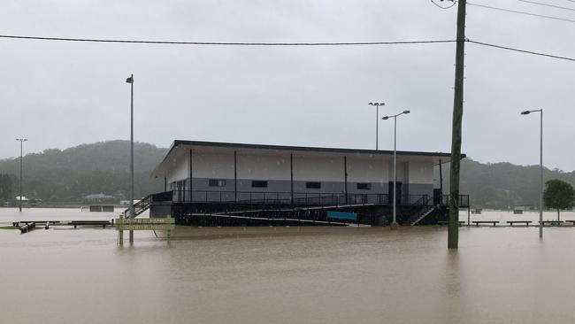
Swiftwater rescuers have plucked two women from the roof of a car inundated by floodwater in a rural suburb of the Gold Coast as showers are forecast to continue until at least Sunday.
It comes as the city marks the 18th week of rain of 20 weeks so far this year.
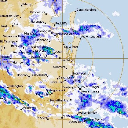
Clagiraba was drenched by 106mm, Mount Tamborine 100mm and Currumbin Creek 73mm in the 24 hours to 9am on Monday, while Gold Coast Seaway received 13mm, Coomera 5mm and Coolangatta just 3.4mm.
Queensland Fire and Emergency Services swiftwater rescue technicians attended Bonogin Rd and Broadoak Crt at Bonogin about 10.40pm on Sunday, a spokesman said.

The pair found the women waiting for help on the roof of the vehicle and managed to get them to dry land within 10 minutes or so.
Queensland Ambulance Service was also called, but the women were not treated by paramedics, a spokeswoman said.
The rescue on closed Bonogin Rd comes as the Bureau of Meteorology has forecast ongoing rain for the Gold Coast throughout the week.
On Sunday, the bureau said heavy rain had eased across statewide, but light and moderate rain was expected to fall across southeast Queensland in “the next few days”.
No flooding warnings were active for Gold Coast creeks and rivers early on Monday morning, but “minor to moderate flooding is occurring across many catchments in southern and central Queensland”.
However, it will not take much rain to lead to the flooding of local creeks and rivers.
“Due to the saturated catchments, any further rainfall may cause local creek and river rises or prolong existing flooding,” the bureau warned.
“There is also an increased risk of falling trees, even with relatively low wind speeds, and landslides.”
Showers forecast later in the week were “not expected to be as heavy or widespread” as last week.
Hazardous surf conditions in Queensland have now eased, with a warning for Gold Coast waters cancelled on Sunday.
Meanwhile, it appears northern New South Wales has largely dodged a repeat flood event.
As of Sunday afternoon, flooding was “no longer expected along the Tweed, Brunswick, Richmond and Wilsons rivers”.

The bureau has urged Gold Coast residents to stay up to date with weather forecasts and warnings “due to the evolving nature of this weather event”.
The bureau has predicted showers throughout Monday, which was forecast to be unpleasantly humid. It’s likely to feel like 25.4C with a relative humidity of 94 per cent.
The highest expected temperature was 27C - three degrees higher than Sunday’s max.
The maximum on Monday is the highest the mercury is expected to climb this week.

Winds were forecast to be west-northwest around 5km/h in the morning shifting to east-northeast around 14km/h in the afternoon.
Earlier, the Bulletin reported the La Niña phenomenon continues to be a pest, bringing 1600mm of rainfall in the first five months of 2022 – 400mm more than last year.
To put that in perspective, the average monthly rainfall for May is 109mm.
The bureau expects wet weather to continue through June-August, which are tipped to bring rainfall above the median.
WEATHER FORECAST
- Tuesday, May 17: Showers. Min – 20. Max – 25.
- Wednesday, May 18: Shower or two. Min – 19. Max – 25.
- Thursday, May 19: Shower or two. Min – 18. Max – 23.
- Friday, May 20: Shower or two. Min – 17. Max – 23.
- Saturday, May 21: Showers. Min – 18. Max – 22.
- Sunday, May 22: Showers. Min – 17. Max – 22.
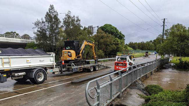
ROAD CLOSURES
Listed by Gold Coast City Council at 8am
- Somerset Drive, Mudgeeraba
- Bonogin Road, Bonogin
- Tallebudgera Creek Road, Tallebudgera Valley
- Hardys Road, Bonogin/Mudgeeraba
- Clagiraba Road, Clagiraba
- Birds Road, Guanaba
- Lanes Road, Wongawallan
RAINFALL TOTALS
In the 24 hours to 9am Monday
- Clagiraba: 106mm
- Mount Tamborine: 100mm
- Upper Springbrook: 77mm
- Currumbin Creek: 73mm
- Canungra: 65mm
- Mudgeeraba 60mm
- Clearview: 59mm
- Pacific Pines: 56mm
- Upper Tallebudgera: 55mm
- Carrara: 49mm
- Neranwood: 46mm
- Little Nerang Dam: 46mm
- Tallebudgera: 42mm
- Worongary: 55mm
- Tallai: 50mm
- Wongawallan: 35mm
- Evandale: 32mm
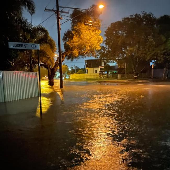
- Loder Creek: 24mm
- Monterey Keys: 16mm
- Gold Coast Seaway: 13mm
- Oxenford: 13mm
- Molendinar: 10mm
- South Stradbroke: 9mm
- Coomera: 5mm
- Coolangatta: 3.4mm
- Steiglitz: 1mm
Beaches closed as city braces for more wet weather
Gold Coast beaches have closed as the region braces for a wet week and dangerous swell.
On Wednesday morning the Gold Coast City Council closed all beaches due to dangerous swell and rough conditions.
Metrologist Helen Reid said there was a large marine warning with Gold Coast seas getting up to 20 to 30 knots.
“The showers will ease going into the weekend,” Ms Reid said.
The weather forecast said there was a possibility of up to 40mm of rain on both Wednesday and Thursday.
She said they were keeping an eye on the river systems on the Coast but they were not expecting flash flooding.
“Since a lot of our river systems were saturated not long ago we will keep an eye on them,” Ms Reid said.
“Keep an eye of any updated warnings on the Bureau of Meteorology website.”
She said the Coast could expect more showers next week.
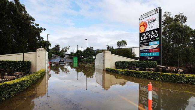
More than 70 sporting ovals on the Coast were closed on Wednesday due to the wet weather conditions.
These ovals include; Surfers Paradise Demons Sir Bruce Small park, Parkwood Sharks Musgrave sports park, Mallawa Sports complex, Coomera Magpies Coomera sports park and more.
To see the rest of the list go to www.goldcoast.qld.gov.au and then sporting field closures.
“We keep our sport and recreational facilities open as much as possible to maximise use. But sometimes we need to close sports fields because of wet weather or for maintenance,” a Gold Coast City spokesperson said.
“It is not possible for Council officers to inspect all sports fields within all parks and weather conditions may change during this time.
“In these cases, it is the responsibility of the respective club onsite to determine playing and/or training conditions.”
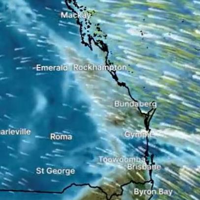
Rain ‘intensifying’ in coming days
May 9: Weather forecasters have warned southeast Queensland will likely cop a drenching in coming days, with some areas along the coast expected to receive more than 400 millimetres of rain.
Forecasts for the Gold Coast have estimated up to 15 millimetres will fall in the centre of the city on Monday before the wild weather ramps up from Tuesday.
The Bureau of Meteorology has warned of “rainfall intensifying over central and eastern Queensland from Tuesday”, accompanied by possible flash flooding and river rises.
Felim Hanniffy, from the Bureau of Meteorology, said Queenslanders would see the heaviest falls from Tuesday-Thursday with the greatest risk for North Queensland.
“It’s beginning to pick up broadly across the eastern half of the state, particularly up over parts of the central coast and northern interior where we have some storms ongoing so that’s a sign of that moisture beginning to build and filter inland,” he said.
“The trough pushes inland on Monday and begins to deepen so it looks like from Tuesday to Thursday for the risk of that very heavy to locally-intense rainfall as well.”
Another bureau meteorologist, Livio Regano, said on Monday morning the “main wave” of rain was expected to impact southeast Queensland between Wednesday-Friday.
“There will be some steady rain from Wednesday with typical daily rainfalls of about 50mm,” he said.
“There is a big cluster around the Sunshine Coast – Brisbane and the Gold Coast have had almost nothing so far but there is still some uncertainty over the next couple of days.”
Sky News meteorologist Rob Sharpe said torrential rain could prove “life threatening” in some areas.
“Some of the worst flooding is going to be in the outback parts of Queensland, but even closer to the coastline we could see some torrential rain at times with life-threatening flash flooding with this event,” he said.
“For Queensland as a whole, I’m thinking it will probably be one of the wettest Mays on record. Probably in the top three.”
Mr Hanniffy said coastal areas could be in line for 200-400mm of rain, but the situation could intensify depending on the activity of the coastal trough.
“Even though the focal point of the heavier rainfall will be further north, it’s likely to be pretty wet across the southeast, especially up the Sunshine Coast on Monday and Tuesday and then broadly on Wednesday as that system to the north shifts south,” he said.
Meteorologist Shane Kennedy said: “Widespread significant heavy falls are possible from Tuesday over eastern and central Queensland as an upper trough and strong high combine to draw moisture well inland.”
The bureau stated a weak trough was extending through the northern and central parts of the state, extending offshore over the southeast coast.
“The northern branch of this trough will start to deepen from Monday increased shower and thunderstorm activity across the interior of the state,” a statement read.
“A strong high over South Australia will drift across southeastern Australia over the next few days, extending a firm ridge over much of the state. The high will reach the Tasman Sea on Tuesday and combine with a deepening interior trough and associated upper level feature, to enhance rainfall over the eastern half of the state.
“A coastal trough may also form near the northeast tropical coast and drift slowly southward along the central coast between Tuesday and Thursday, further enhancing rainfall along the coast.
“Areas of rain and thunderstorm activity are expected to become more widespread over eastern half of the state early this week, with a risk of heavy falls about eastern and central districts from Tuesday.”
FORECAST
- Tuesday, May 10: Shower or two. Min – 18. Max – 24.
- Wednesday, May 11: Rain at times. Min – 19. Max – 23.
- Thursday, May 12: Rain at times. Min – 19. Max – 24.
- Friday, May 13: Showers. Min – 20. Max – 25.
- Saturday, May 14: Showers. Min – 20. Max – 25.
- Sunday, May 15: Shower or two. Min – 20. Max – 26.
Wild weather warning for Gold Coast Hinterland
March 30: A severe weather warning has been issued for parts of the Gold Coast hinterland with the Bureau of Meteorology urging residents to prepare for “damaging winds in excess of 90km/h.”
The warning was issued at 4:56pm on Thursday after a deepening low pressure system in the Tasman Sea made it way south, while a strong pressure system remains dominant over the Great Australian Bight.
The powerful weather system is suspected to make its way toward the coastline as it strengthens across the Border Ranges overnight.
Main areas of concern are the Numinbah Valley and Springbrook.
The wild weather is expected to lash the hinterland on Thursday evening and continue into Friday morning.
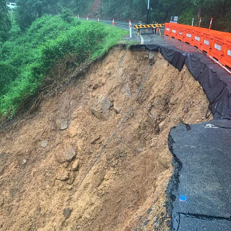
It comes after days of wet weather for the hinterland, with severe rockfalls and landslides closing major mountain roads in Beechmont and Springbrook.
Queensland Fire and Emergency Services have warned residents to remain vigilant, urging people to move their cars under cover and away from trees, secure loose outdoor items, seek shelter and to stay clear from fallen trees and powerlines.
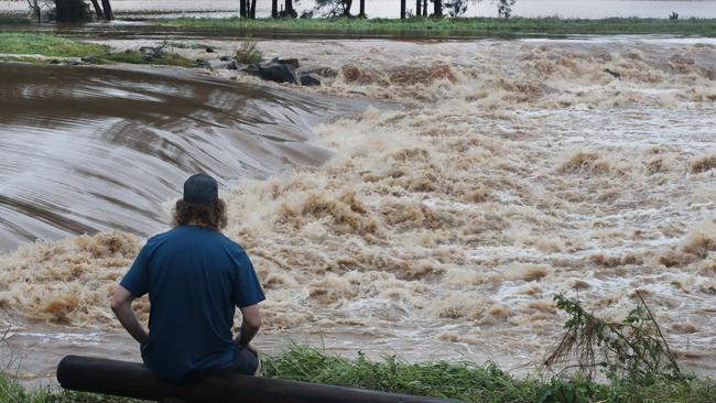
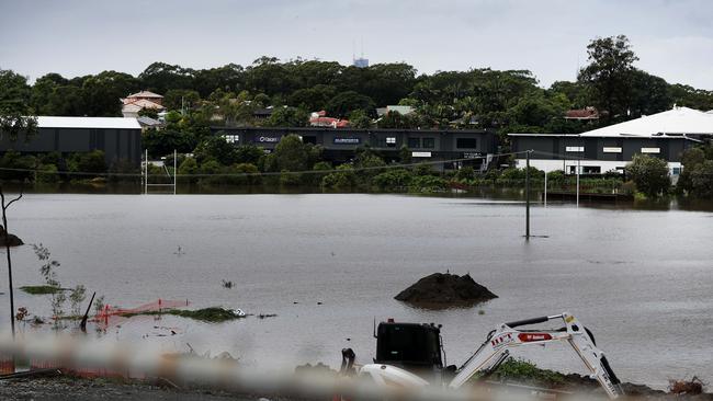
Landslides close roads despite flooding ‘easing’
Earlier: Despite flooding “generally easing” throughout the Gold Coast, we’re not out of the woods just yet, according to forecasters.
It comes as significant landslides shut down major roads in Beechmont and Springbrook, with a huge rockfall spilling out over Neranwood Park to Pine Creek Road in the Gold Coast hinterland.
It is unclear how long the road will take to clear.
A spokesperson from Department of Transport and Main Roads said the road would be closed till further notice.
According to forecasters, there is a chance of “small renewed rises” of creeks and rivers throughout the day.
The Bureau of Meteorology has issued a “final flood warning’ for the Nerang and Coomera Riversa after rainfall totals of up to 54mm were recorded in the 24 hours to 9am Wednesday.
Showers and thunderstorms are expected to continue during Wednesday … “ the bureau stated.
“River and creek levels generally have peaked and are easing across the Pimpama and Coomera River catchments, with small renewed rises possible during Wednesday.
“River levels are easing along the Nerang River. Small renewed rises are possible but river levels at Clearview and Evandale will remain below the minor flood level during Wednesday.
“Creek levels are generally easing along the Mudgeeraba Creek. Small renewed rises are possible during Wednesday.
“Creek levels are generally easing along the Tallebudgera and Currumbin creeks. Small renewed rises are possible during Wednesday.”
Meanwhile, Acting Mayor Donna Gates said Gold Coast City Council’s clean-up and recovery crews were working across the city following heavy rain over the past 48 hours.
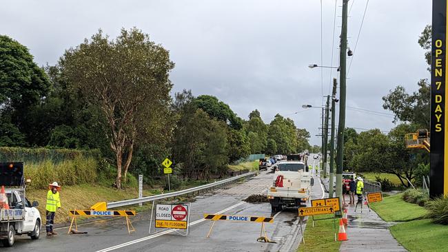
More than 100 staff have been tasked to tackle “local works”, while more than 10 roads remain cut due to floodwaters.
“Before this latest rain, our officers were already heavily involved in the recovery phase of operations, following the substantial weather event three weeks ago,” Cr Gates said.
“This latest weather event was nowhere near as damaging as the previous one but we took all precautions.
“The beaches held up well with no significant scarping.
“Debris along the beaches, in our creeks and canals and throughout the low-lying areas is being cleaned up now and we will be in great shape for the Easter school holiday break.’’
Council officers have been watching the Albert and Logan river systems, with those two rivers expected to peak around midday on Thursday.
“The good news is that the peak will be well short of the near record levels we saw earlier in the month,” Cr Gates said.
FLOODED ROADS AT 1PM
Listed by Gold Coast City Council
- Wongawallan – Lanes Road
- Bonogin – Bonogin Road
- Tallebudgera Valley – Mt Cougal Road
- Currumbin Valley – Kianga Court
- Mudgeeraba – Hardys Road
- Guanaba – Birds Road
- Beechmont/Clagiraba – Beechmont Road
- Main Beach – SeaWorld Drive
- Guanaba – Billiau Road
- Clagiraba – Clagiraba Road
- Mount Nathan – Clagiraba Road
- Tallebudgera Valley – Tallebudgera Creek Road
* Road closures as listed on the Gold Coast City Council Disaster and Emergency Dashboard
Roads closed across city as wet weather ramps up again
March 29: Forecasters have warned nearly 100mm of rain could be dumped on the Gold Coast on Wednesday as flood warnings remain active for the Coomera and Nerang Rivers.
On Tuesday, the Bureau of Meteorology predicted a weather system which resulted in massive rainfall totals on the Coast early this week – including 358mm at Tallebudgera – would ease.
Gold Coast Seaway received 292mm, meaning it has been the wettest March on record for the weather station.
Bureau senior meteorologist Helen Reid said “the band of heavy rainfall had shifted from southeast Queensland” after rivers were subject to “rapid rises”.
However, constant rain has been falling on the Coast on Wednesday morning, adding to already saturated catchments.
LISMORE FLOOD BLUNDERS: SIRENS FAIL, RAIN GAUGES WRONG
The system which was expected to shift south has stalled and has been impacting southeast Queensland and northern New South Wales, sparking worrying flooding in areas like Lismore, which were devastated by record flooding in late February.
The bureau’s current Wednesday forecast advises of a cloudy day, with a high chance of showers (80 per cent), becoming less likely in the afternoon, with west to south-westerly winds of 15-25kmh, easing in the evening.
Ms Reid has weighed in again about the weather system’s renewed path.
“It’s happened just the right distance offshore, it’s got just enough moisture linked into it and got enough rotation that we are seeing that northward progression occurring,” she said.
“It’s all been lined up with the upper level atmosphere, it hit the sweet spot to bring a little bit of misery to the Gold Coast.”
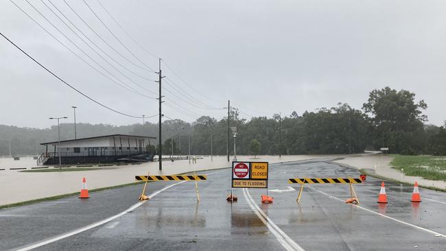
More than 10 roads remain closed or have been shut on the Coast due to flooding, according to Gold Coast City Council, but that is down from about 30 roads on Tuesday morning.
The Coast recorded the largest rainfall totals in the state in the 24 hours to 9am Tuesday.
Downpours caused landslides, flash flooding and forced the closure of a small number of schools.
Serious landslides occurred on Gold Coast-Springbrook Rd, between Neranwood Park and Pine Creek Rd, as well as on Beechmont Rd, between Nerang-Murwillumbah Rd and Binna Burra Rd. A landslide also closed Tomewin Rd.
Flash flooding, roads and schools closed as deluge drags on
March 29: The Bureau of Meteorology has cancelled a Severe Weather Warning for the Gold Coast, but downpours and possible thunderstorms remain likely throughout Tuesday.
Roads are starting to reopen after 30 thoroughfares were closed in the city earlier in the day.
The bureau has stated: “Severe weather is no longer occurring in Queensland”
“The immediate threat of severe weather has passed, but the situation will continue to be monitored and further warnings will be issued if necessary,” the statement read.
It’s expected the worst of the wet weather will descend on northern New South Wales, where communities such as Lismore and Murwillumbah were ravaged by floods in late February.
However, a Flood Warning remains active for the Nerang and Coomera rivers.
“Flooding is occurring along the south coast catchment,” the bureau stated
“Widespread heavy rainfall totals over 250mm have been recorded across the south coast catchment since 9am Monday. The heavy rainfall has caused rapid river and creek level rises and flooding in the south coast catchment.
“Further showers and thunderstorms are forecast in the catchment area for Tuesday.”
The bureau stated minor flooding has been occurring along the Coomera River and its tributaries, while river levels were elevated along the Nerang River.
Flooding has also been occurring along Currumbin, Mudgeeraba and Tallebudgera creeks.
Dozens of roads closed in wake of torrential downpours
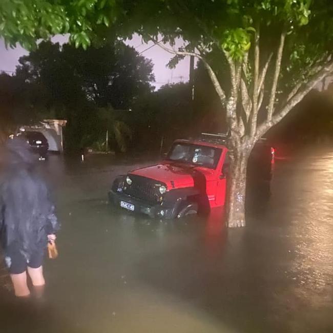
Earlier: Massive rainfall totals have been recorded on the Gold Coast overnight, leading to flash flooding in some areas – and the rain is expected to continue throughout Tuesday.
The southern Gold Coast copped the worst of the downpours, with 350 millimetres dumped on some suburbs on Monday, including 150mm in about six hours overnight.
Tallebudgera copped the worst of the rain in the southeast at 358mm.
Some homes were impacted by floodwaters, while others were sandbagged to prevent flooding.
Properties across Southport lost power just before 11pm Monday night.
Queensland Fire and Emergency Services was called to several swiftwater rescue jobs involving people stuck in flooded vehicles across the city, but occupants were able to free themselves from the vehicles, a spokesman said.
In total, about 30 roads across the city have been closed due to floodwaters, while three schools have been closed – Elanora State High School, Ingleside State School and Tallebudgera State School.
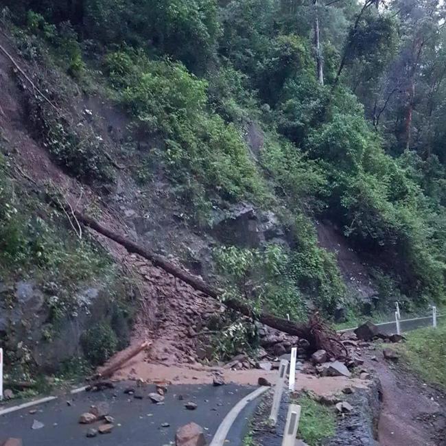
The Department of Transport and Main Roads has warned Gold Coast-Springbrook Rd from Neranwood Park to Pine Creek Rd has been closed due to a “significant landslip caused by the recent weather event”.
The Bureau of Meteorology issued a Flood Warning on Tuesday morning, warning heavy rain had caused “rapid river and creek level rises and minor to moderate flooding.
Moderate flooding has occurred along the Coomera River and its tributaries, while significant river rises have occurred along the Nerang River.
Flooding was also recorded along Currumbin, Mudgeeraba and Tallebudgera creeks.
The bureau has forecast ongoing showers throughout Tuesday, easing off later in the day.
The Coast has been warned of potential thunderstorms, possibly bringing heavy rain “which may lead to flash flooding”.
“Large and powerful surf conditions in the afternoon and evening are expected to be hazardous for coastal activities such as rock fishing, swimming and surfing,” the bureau stated.
Gold Coast City Council stated all beaches have been closed until at least midday Tuesday.
Bureau flood alerts were issued early on Tuesday morning for Loders Creek near Southport and Tallebudgera Valley, but they have cancelled.
A bureau spokesman warned: “Flash flooding can occur with minor notice.”
The bureau is due to update on the conditions later on Tuesday, but a Flood Watch and Severe Weather Warning remains active for southeast Queensland.
The council stated early on Tuesday the city had experienced “significant rainfall”.
“Conditions appear to be easing, however the Bureau of Meteorology’s severe weather warning for heavy rainfall, which may lead to flash flooding, remains in place,” a statement read.
“There are currently about 30 roads closed due to flooding today. The City is urging Gold Coasters to drive to the conditions and remember that if it’s flooded, forget it.
“Sandbagging stations are open again today. There were approximately 1400 sandbags collected yesterday across the City.
“City crews will be going out this morning to assess damage and begin any clean up works required.
For flood or storm damage call the SES on 132 500 and in a life-threatening emergency call triple-0.
RAINFALL TOTALS TO 9AM
– Coplicks Bridge, Tallebudgera – 358mm
– Oyster Creek, Burleigh Heads – 343mm
– Monterey Keys – 312mm
– Gold Coast Seaway – 307mm
– Tallebudgera Creek – 297mm
– South Stradbroke Island – 312mm
– Couran Point – 293mm
– Molendinar – 257mm
– Loders Creek – 234mm
– Coolangatta – 231mm
FLOODED ROADS AT 7.30AM
Listed by Gold Coast City Council
– Alberton – Stapylton Jacobs Well Road
– Wongawallan – Tamborine Oxenford Road
– Burleigh Waters – Galeen Drive
– Pimpama – Pimpama Jacobs Well Road
– Oxenford – Kopps Road
– Arundel – Captain Cook Drive
– Labrador – Musgrave Avenue
– Robina – Robina Town Centre Drive
– Robina – Scottsdale Drive
– Burleigh Heads – Tallebudgera Creek Road
– Ormeau/Yatala – Cuthbert Drive
– Gilberton/Stapylton – Burnside Road / Rossmanns Road
– Mudgeeraba – Gold Coast Springbrook Road
– Oxenford – Old Pacific Highway
– Helensvale – Siganto Drive
– Guanaba – Birds Road
– Mount Nathan – Clagiraba Road
– Guanaba – Tarata Road
– Carrara/Nerang – Chisholm Road
– Labrador – Frank Street (Gold Coast Highway)
– Clagiraba – Clagiraba Road
– Bonogin – Bonogin Road
– Willow Vale – Hotham Creek Road
– Tallebudgera – Tallebudgera Connection Road
– Tallebudgera Valley – Tallebudgera Connection Road
– Currumbin Valley – Currumbin Creek Road
– Currumbin Valley – Kianga Court
– Worongary – Vince Hinde Drive
– Mudgeeraba – Berrigans Road
– Mudgeeraba – Somerset Drive
– Mudgeeraba – Gunsynd Drive
– Mudgeeraba – Hardys Road
– Tallebudgera Valley – Mt Cougal Road
– Tallebudgera Valley – Tallebudgera Creek Road
– Reedy Creek / Tallebudgera Valley – Old Coach Road
* The condition of some roads has not been updated since Monday
SANDBAGGING STATIONS
Open until 6pm Tuesday
– 232 Old Pacific Highway, Pimpama
– 42-44 Boyd St, Bilinga
– 61 Hutchinson St, Burleigh Heads
QFES FLOOD ADVICE
– Never drive, walk or ride through flood waters. If it’s flooded, forget it.
– Seek shelter, preferably indoors and never under trees.
– Avoid using the telephone during a thunderstorm.
– Beware of fallen trees and powerlines.
– For emergency assistance contact the SES on 132 500


Join the conversation

‘If you build it, they will come’: City urged to start critical infrastructure
Queensland Premier David Crisafulli has addressed questions about the future of Light Rail Stage 4 and others have shared their concerns about the lag in critical infrastructure. ROLLING UPDATES
Read more

What’s happening with heavy rail extension to airport
A transport funding update has cast new light on long-held ambitions to extend the Gold Coast’s heavy rail line to the airport. FULL DETAILS
Read more