
Fears could trigger retreat on light rail and Gold Coast development
FUTURE routes of the light rail and other developments could be in jeopardy after the council pushed ahead with an updated planning instrument, a town planner warns.
Council
Don't miss out on the headlines from Council. Followed categories will be added to My News.
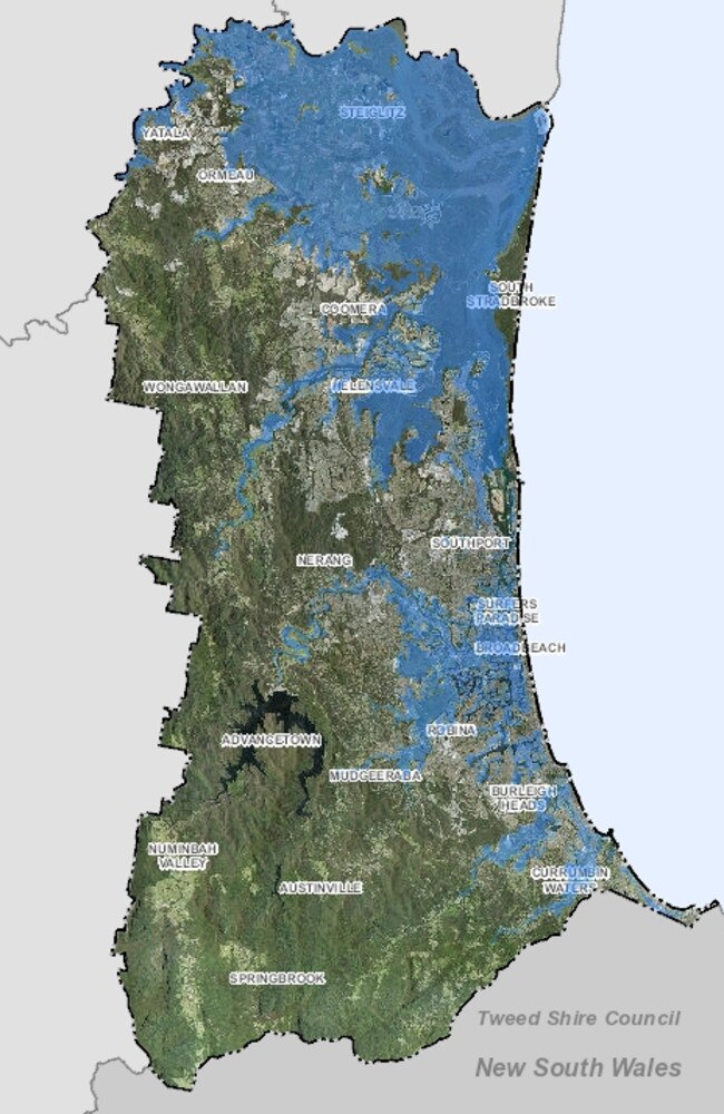
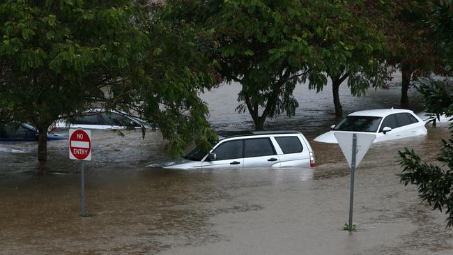
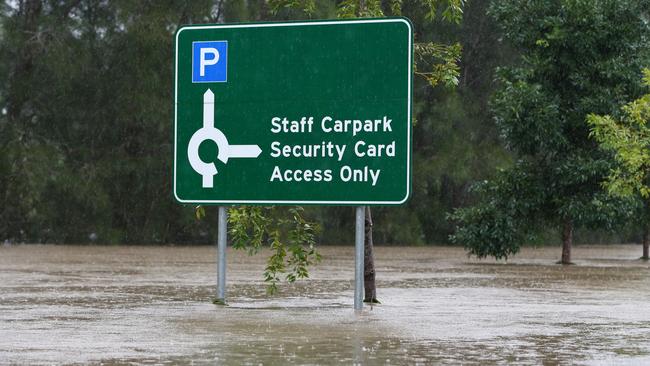
NEW city flood mapping could put future stages of the light rail at risk, trigger a “retreat policy” back from the coastline and create an insurance nightmare for property owners.
The bombshell warnings about Gold Coast development are included in correspondence from leading town planners to State Development Minister Cameron Dick.
The Bulletin has obtained the lengthy submission to the minister, sent after the Gold Coast City Council updated its flooding overlay maps on its website, showing most of the coastline under water in a major flooding event.
Separate complaints from residents in feedback to the City Plan back the submission by the Zone Planning Group, headed by respected planner and director David Ransom.
“While acknowledging that council has every right to amend flood levels in response to the most recent flooding and climate information, our principal complaint is council has not prepared a publicly available technical report which demonstrates how particular Q100 flood levels were determined,” Mr Ransom wrote.
“And hence there is no way of independently verifying whether council actions are correct, let alone reasonable.
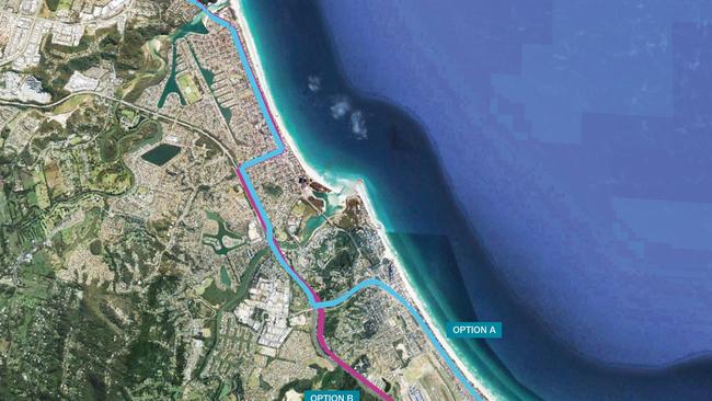
WHERE LIGHT RAIL FEEDER LINES WILL RUN ON COAST
“Given the importance of this matter, we believe that it is essential that a technical background report is produced and made publicly available and contend that the public advertising process undertaken by council is incomplete and invalid because this has not been done.”
The Zone Planning Group warned that:
• A 75cm increase in the Q100 level (a one-in-a-hundred-years flood) will have a “significantly adverse effect on the financial interests of thousands of residents in Burleigh Heads, Palm Beach and Currumbin”.
• Areas of these suburbs will be “practically undevelopable” if the new mapping is rubber stamped by the Government.
GET A NEW SET OF HEADPHONES WITH YOUR DIGITAL SUBSCRIPTION
• This will prevent an “intensified population catchment” being created west of the Gold Coast Highway to support the proposed light rail extension to Coolangatta.
• The council failed to consider the impact on insurance policies which could increase from $2000 annually to $8000 where flood events occurred.
• The council is “effectively advocating a retreat strategy” in the Tallebudgera and Currumbin Creek catchments.
• Public consultation should recommence with the necessary background reporting made for an independent review.
• Information sessions should be held at Burleigh, Palm Beach and Currumbin to explain how the changes were arrived at and the consequences.
The group said the council, in preparing the flood maps, failed to acknowledge a 15-month investigation of “wave set up and storm tide” at Tallebudgera and Currumbin, which was yet to be completed.
“Council are approaching flooding issues in the city in a piecemeal and reactive manner than a holistic manner,” Mr Ransom wrote.
“Many flooding issues are interrelated and they should be reviewed as one exercise, not as many smaller exercises which are not co-ordinated.”

Planners maintained an example of this was the council’s recent move to prevent residential development on elevated podiums in flood-affected areas.
Mr Ransom declined to comment yesterday, but the Bulletin is aware of other submissions by community stakeholders voicing similar concerns.
A council source said planning changes that prevented developments on podiums in flood-prone areas were designed to protect residents.
“What would have been proposed in an area that floods is you are building a house on stilts, or even a high rise so water can go under it. This temporary local planning law prevents developers from lodging those applications using the latest technical knowledge,” the source said.
The council had sought State Government backing for changes to the City Plan to provide more certainty when opposing some applications in flood-prone areas, another source said.
The amendments would protect the council from costly legal action in development applications in which developers had “pushed the envelope” with applications in areas like the Carrara floodplain.
Council planning committee chairman Councillor Cameron Caldwell told the Bulletin yesterday: “Council will not support development in areas where it is considered there is a significant risk to people and property. Our floodplains provide essential flood storage and open space for our city and need to be protected for that purpose.”
GET A NEW SET OF HEADPHONES WITH YOUR DIGITAL SUBSCRIPTION
A State Development spokesman said the department was aware of Mr Ransom’s concerns about technical reports that supported the council’s flood overlay mapping for the City Plan.
“The proposed major amendment is currently with the Gold Coast City Council awaiting their adoption,” the spokesman said.
The Government was seeking more information on the council’s proposed local planning instrument changes and “once this information is received a full assessment will be undertaken”.
“The council has advised the purpose of the proposed TLPI (temporary local planning instrument) is to improve the flood hazard resilience of development within the Gold Coast.
This is primarily a local planning matter. Any queries relating to the TLPI should be directed to the council.”

Poop ponderings: How will city dispose of cableway visitors’ waste?
The Springbrook cableway project could attract 580,000 visitors annually, but the problem of what to do with all their waste has raised its head.

Millionaire’s Row vs Cane Fields: Gold Coast’s bitter housing divide
The Gold Coast’s biggest development fight is where to fit one million people. The choices made will have lasting consequences, writes Paul Weston.