
Tropical Cyclone Oma: Gold Coast set for up to 240mm of rain as cyclone sits off Queensland Coast
Sandbag machines are already filling bags as Gold Coasters prepare for gale-force winds and heavy rain as Tropical Cyclone Oma makes its way towards southeast Queensland. SEE THE LATEST UPDATES
Lifestyle
Don't miss out on the headlines from Lifestyle. Followed categories will be added to My News.
GOLD Coast City Council workers have begun providing sandbags ahead of Tropical Cyclone Oma’s predicted arrival this weekend.
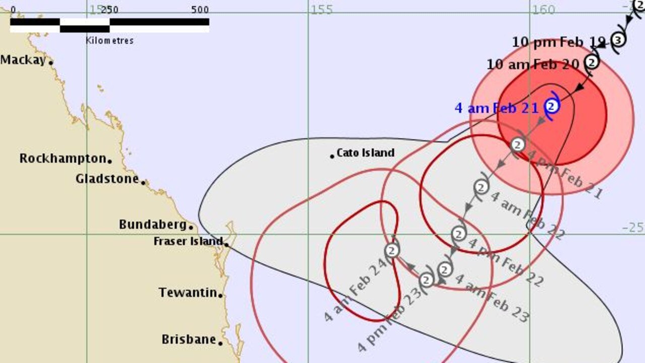
The path of the category 2 system is unpredictable as it sits off the east coast, with at least 20 different possible tracks it could take over the next 24 to 48 hours.
The sandbags are being passed out at the Reedy Creek Community Waste and Recycling Centre, where organisers have already posted signage.
They are also being distributed at locations in Coomera and Tugun, with a 15 per household limit currently in place.
A Council spokeswoman said they didn’t want to “start panic” by providing the sandbags, and only hoped to keep people prepared and ready for any possibility.
Information being distributed at the sight advises homeowners on how to use sandbags to prevent flooding.
“Sandbags should be placed over floor wastes and drains … to prevent backflow of grey water entering,” it reads.
“Sandbags should also be used in front of doorways, roller doors and brickwork vents.
“Before building a sandbag wall consideration should be given to how you would remove floodwater that could become trapped between the sandbag wall and your building.”
People concerned for their homes and businesses in flooding should also remove valuables off the floor and from low cupboards, as well as turning off power and gas at the mains.

Earlier:
Gold Coast Mayor Tom Tate has called for residents to “prepare themselves” ahead of Cyclone Oma’s arrival over the weekend.
The tropical cyclone looks set to bring up to 240mm of rain and winds of up to 90km/h, which Mayor Tate said should begin in the next 24 hours.
“I have activated, for those who want to get ready, sandbagging and the machines are already filling the bags,” he said.
“We’re limited to 15 bags per household at the moment. If you want to prepare yourself and get out there the bags are ready for you now.”
“We looked at the likelihood that it would go up north but planning is everything, so if it does come straight for the Gold Coast we’ve got to be prepared for it.”
Mayor Tate said the Gold Coast has prepared for the Oma since the damage caused by Cyclone Oswald in 2013.
“Oma is a lot more passive, when you add the swell and tides and timing with it, it adds to the coastal damage there,” he said.
“I don’t see damage as bad as Oma especially in the hinterlands, all I’m saying is abundant caution is the key and make sure your first aid kit is up to date.”
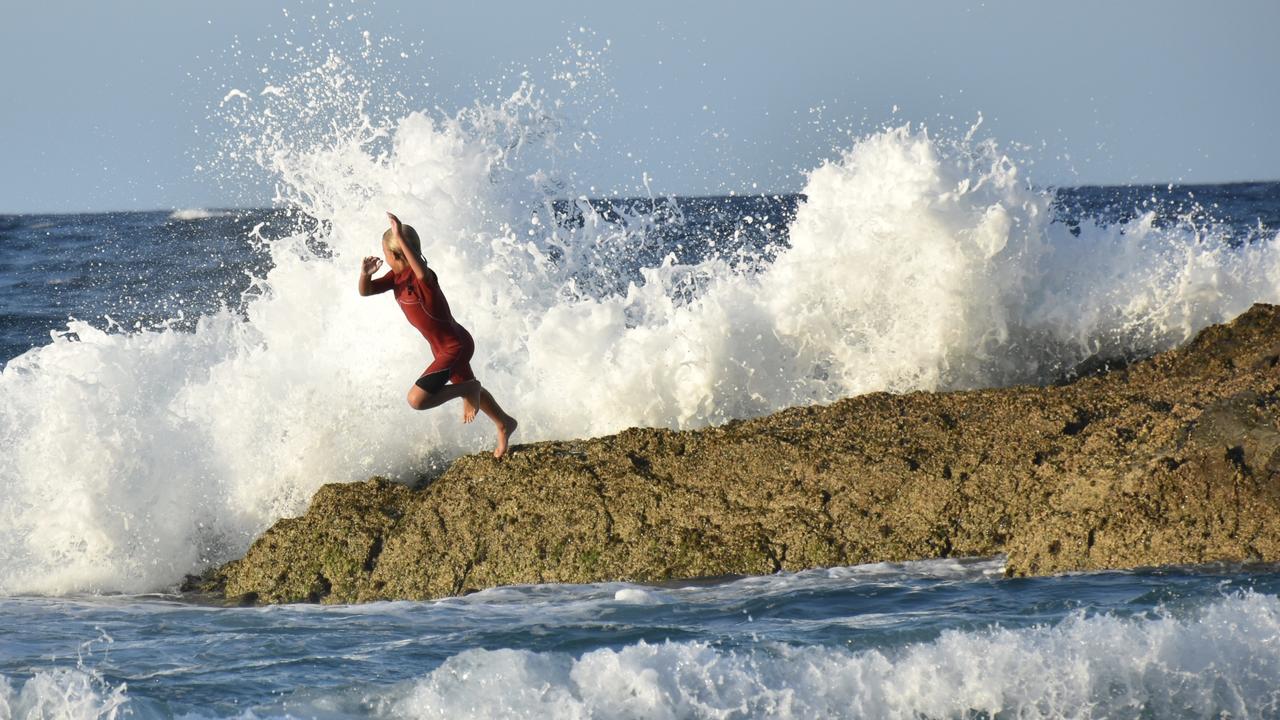
All Gold Coast beaches are now closed, along with the majority of Sunshine Coast beaches. All beaches from Fraser Island down to the Qld border are likely to be closed by day’s end. Surf conditions will be powerful – please stay out of the water. #CycloneOma pic.twitter.com/Qf9RMKtHAP
— Surf Life Saving QLD (@lifesavingqld) February 21, 2019
The weather bureau earlier this week said the Coast was likely to receive as little as 5mm of rain, but by last night was saying it could be as high as 240mm between Saturday and Monday.
The Gold Coast City Council’s disaster management unit has been put on alert as it monitors Oma’s path.
Last night the cyclone sat 1110km east of Brisbane and was moving southwest at 9km/h.
Weather bureau meteorologist Adam Blazak said gale-force winds would start to hit the Coast on Friday, reaching speeds of between 60km/h and 90km/h.
OTHER NEWS:
Coast’s incredible view of supermoon
Parents create Facebook page after school lockdown
RFG shares at new low after court judgment
“This is enough to bring down large tree branches,” he said.
“Hazardous beach conditions and abnormally high tides will occur and from Saturday we urge people to keep up to date with the forecasts because there are different scenarios which could play out.
WE’RE REMOVING ANYTHING NOT BOLTED DOWN
“If there is a crossing (of the coastline) it will be a significant event for whoever is in its path.”
Mr Blazak said heavy showers were expected to fall from Saturday.
Rainfall of 30-90mm was expected on Saturday and Sunday while falls on Monday could be between 20-60mm.
Erosion and scarping were recorded at beaches across the Coast while streets in the low-lying Budds Beach area flooded yesterday morning at high tide.
This is expected to occur again in coming days during the year’s highest tides.
OUCH: OMA FLATTENS SURFERS ON ROCKS

Hinze Dam sits at 93 per cent capacity. There were no concerns yesterday about its storage capacity or any plans to release water.
Council crews were completing work on the rockwall at Narrowneck before the worst of the weather hits on Friday.
Mayor Tom Tate said the city’s preparations were well underway.
Cr Tate said he did not expect Oma to be as bad as the devastating impact of ex-tropical cyclone Oswald in 2013.
“The disaster management unit has moved to an alert status, which means we have doubled the number of staff involved,” he said.
SUBSCRIBE TO THE GOLD COAST BULLETIN — JUST $1 FOR THE FIRST 28 DAYS

“We are tracking Oma and there are 20 different scenarios of where it could go.
“Let’s see what mother nature has to hand out, but we are in a good position.
“I would say to everyone this is not the time to panic, this is the time to plan.”
Council workers removed fencing and a shower from the southern end of Kirra, which had already been affected by surging tides. Fencing was also removed at Currumbin.
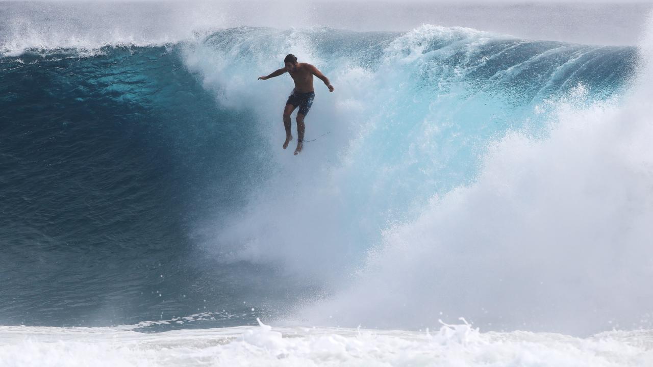
With swells expected to reach as high as 6m, Cr Tate urged people not to walk on the seawall at The Spit or on the groynes.
“As the swell increases, it could get up to 6m high and take you off the wall,’’ he said.
“It is not just your life in danger but you are endangering the rescuers who have to come and fish you out.”
Water police warned boaties and swimmers to stay away from the surf in the face of “extreme conditions’’.
Senior Sergeant David Edden said people should avoid water activities near surf-exposed areas for at least the next five days.
“We are expecting to see extremely dangerous conditions on the water and we are urging everyone to make smart decisions and stay safe,” he said.
“All boaties, fishers, surfers and swimmers should reconsider any plans which involve the surf over the coming days.”

What to expect at this year’s Crafted Beer Festival
The excitement is brewing for the Gold Coast’s favourite frothy celebration, with beer lovers flying in from across the globe to crack a cold one and support the local scene. Here’s what you can expect.

Hot tub, fire pit, fine dining: Inside stunning glamping getaway
There’s no need to ruff it if you want to take your dog on holidays. We road test the Gold Coast hinterland’s most luxe glamping destination.