
Severe weather: Gold Coast smashed by ex-tropical cyclone Debbie’s ‘sting in the tail’
11.15PM: A FLOOD warning has been issued for the Nerang, Coomera and Pimpama Rivers after another late-night deluge took rainfall totals to more than 600mm.
Lifestyle
Don't miss out on the headlines from Lifestyle. Followed categories will be added to My News.
11.15PM: A FLOOD warning has been issued for the Nerang, Coomera and Pimpama Rivers after another late-night deluge took rainfall totals to more than 600mm.
Upper Springbrook was smashed with 75mm of rain in just one hour to 11pm - adding to 545mm that had already made it’s way toward the catchment and into swollen rivers.
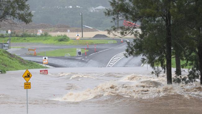
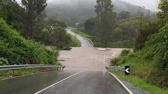
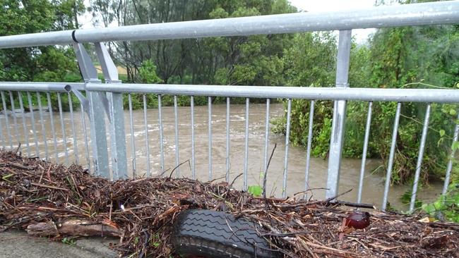
Major flooding is rising in the headwaters of the Coomera River, fast river rises are occurring along the Pimpama River and the Nerang River is expected to have minor flooding at Evandale on Friday morning with the high tide.
In some cases, the rivers and creek depths have increased from 1m to 5m in the space of 12 hours — taking it well above major flood level.
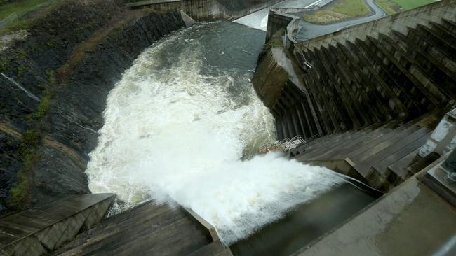
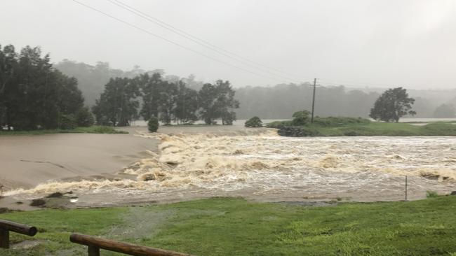
The Hinze Dam is spilling excess water and outflows have increased with minor flood levels.
Stream rises and moderate flooding is also occurring in Mudgeeraba, Tallebudgera and Currumbin Creeks.
9PM: CYCLONE-force wild winds are set to lash the Gold Coast tonight as the tail of ex-tropical cyclone Debbie packs a punch.
Downed powerlines have already left more than 2000 homes without power from Yatala to Tallebudgera and out to the hinterland. Power has also been cut to 27,000 homes in Brisbane.
The heaviest rainfalls — which dumped a total of 545mm across the past 36 hours — have now passed but the ‘core’ and tail of ex-tropical cyclone Debbie is bringing Category one cyclone force wind gusts of up to 125km/h..
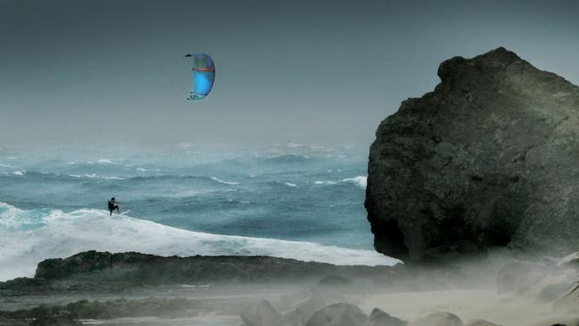
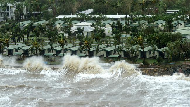
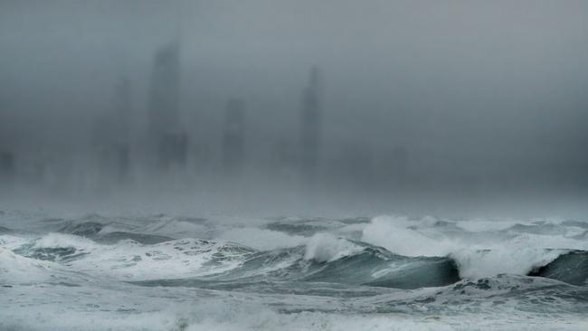
The rain will ease throughout tonight as the weather system heads out to sea but authorities warn up to 4m waves will pound the city’s beaches tomorrow.
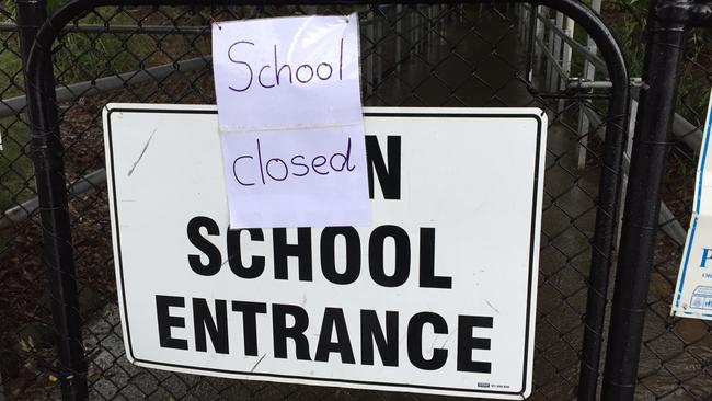
Beaches will remain closed tomorrow along with all schools as the clean up from extensive flooding gets underway.
Upper Springbrook recorded 545mm since 9am yesterday and Numinbah has seen 539mm of rain.
Rainfall closer to the coastline has been substantially less with Coomera Shores recording 189mm and 170mm at The Seaway.
Meanwhile, Tweed residents face a nervous night with moderate to major flooding expected from the Tweed River at Murwillumbah, Chinderah and Kingscliff.
Up to 417mm of rain has fallen in the past day with the Tweed River at Murwillumbah expected to reach major flood late tonight — inundating 176 homes and cutting off the railway station.
Some houses in Chinderah and Kingscliff may also be flooded if the river continues to rise as predicted. Kyogle locals have been told to evacuate immediately.
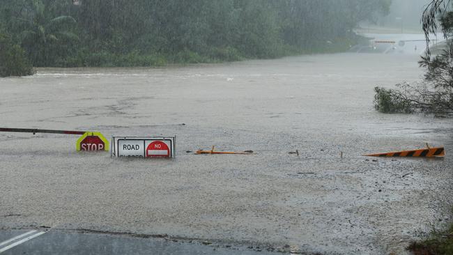
Roads along Tweed River in Chinderah are now submerged in water as the river steadily rises.
Cars are being forced on to one side of the road as torrents of water strewn with debris run across the lanes.
An abandoned motorhome parked too close to the river is partially submerged up to its wheels while a houseboat is flush against the river bank.
Despite the weather, residents dressed in raincoats and armed with umbrellas are walking along the road to check out the sights
The Hacienda Caravan Park which sits right on the Tweed River has been cordoned off by police due to flooding.
Chinderah Bay Dr is almost completely submerged by water and motorists are advised to avoid the area
Gold Coast City Council will close the evacuation centres at Helensvale, Nerang and Elanora at 10pm.
The centres at Robina and Ormeau will remain open until further notice.
RAINFALL FROM 9AM WEDNESDAY TO 7PM THURSDAY:
*Upper Springbrook: 545mm
*Numinbah: 539mm
*Murwillumbah: 250mm
*Coomera Shores: 189mm
*The Seaway: 170mm
*Coolangatta: 126mm
7.15PM: More than 100 people have taken refuge at the Kingscliff evacuation centre tonight.
Residents from Chinderah and Kingscliff have taken blankets, pillows, towels and bags of clothing as they brace for a king tide later tonight for the Tweed River.
One resident has even brought a pet cockatiel to the evacuation centre, while another family couldn’t risk leaving their border collie at home.
Other residents have been able to secure accommodation in Casuarina but had to have their own transport to make it down that far.
Tony Lowndes of Drifter’s Village in Chinderah said while he wasn’t too worried about his property he didn’t want to leave his home but decided to be safe than sorry.
“We’re about 800m from the ocean and 800m from the river on each side,” he said.
“But they’re expecting more (rain) this time round.”
6PM: Drains have become waterfalls in northern Gold Coast suburbs with heavy rain continuing to lash the city. Another 250mm is still expected to fall on the Gold Coast tonight as the tail end of ex-tropical cyclone Debbie moves across the city.
Low-lying areas of Currumbin and Tallebudgera face the most significant flood threat along with 2000 residents on the Tweed who have been ordered to evacuate.
74 Gold Coast roads are closed, the SES has managed 184 jobs across 13 teams and the Hinze Dam is over 100 per cent capacity and spilling.
Winds are currently gusting up to 60km/h with the worst of the storm to hit from 7pm.
All schools and beaches will remain closed tomorrow.
#ParadisePoint experiencing some power outages @Energex will be working hard to restore asap but safety in these conditions must be priority
— Verity Barton MP (@Verity_BartonMP) March 30, 2017
Another two evacuation centres are about to be opened as the north and south of the Gold Coast.
Mayor Tom Tate, at his latest media briefing, said the Ormeau Centre and Elanora Library would be opened from 6pm, backing up other centres at Helensvale, Robina and Nerang.
No residents are currently using the centres but welfare services will advise the city’s homeless to take shelter.
“If your house is not liveable, go to your family and friends. Leave the evacuation centres for the needy,” Cr Tate said.
The high tide around 11pm is expected to cause concern only at Paradise Point.
4.30PM: Tallebudgera Creek has broken its banks with backyards rapidly flooding and 2000 Tweed residents have been ordered to evacuate immediately.
It comes as the most intense part of the storm is starting to hit the Gold Coast, bringing heavy rain, destructive winds and threatening to isolate residents.
Brown, murky water and debris is flowing down the fast-paced Tallebudgera creek with an emergency alert issued for residents who are expected to be cut off by rising floodwaters tonight.
An evacuation order has been issued for 2000 residents in Chinderah, Kingscliff, Fingal Head and Bilambil as the Tweed River threatens to go into major flood, reaching up to 5.6m.
Power has been cut to more than a 1000 homes, including Tamborine Mountain, Tallebudgera Valley, Paradise Point and Cedar Creek.
Gold Coast Mayor Tom Tate and fire chiefs are concerned about severe flooding that may temporarily isolate Tallebudgera residents if the city is smacked with a major downpour, as predicted tonight.
“The Tallebudgera Valley will experience rising water levels in the next few hours,” Councillor Tate told the Gold Coast Bulletin.
“Tallebudgera Connection Road between Andrews Road and Tallebudgera Creek Road is closed. You should prepare for short term isolation.
“The roads will be substantially inundated. People won’t be able to get out.”
State Emergency Service crews are being called in to back up police and firies as the worst of the rain and winds are about to hit the Glitter Strip.
Inside the SES headquarters at Southport, staffers are calling out to volunteers as they prepare to expand their crews for a long night of potential rescues and evacuations.
Deputy SES local controller Brett Fournier said: “We’ve got 120 jobs on. There are 16 SES crews out there and there are three rural fire brigade crews.
“They are mostly attending to fallen trees, flooded houses and keeping people out of creeks.”
The emergency crews have been briefed and told to expect between 150 to 200mm of rain to be dumped on the Gold Coast in the next four hours.
The council has just announced it had closed all waste and recycling centres. Landfills will remain closed until further notice.
SUBURB-BY-SUBURB RAINFALL DATA: (to 6pm)
— Numinbah: 299mm
— Upper Springbrook: 288mm
— Tallebudgera Creek: 211mm
— Molendinar: 191mm
— Pacific Pines: 158mm
— Miami: 152mm
— Bonogin: 174mm
— Carrara: 157mm
— Evandale: 124mm
— Coomera Shores: 108mm
— Gold Coast Seaway: 105mm
— Biggera Waters: 159mm
— Clagiraba: 162mm
2PM UPDATE: AUTHORITIES are pleading with Gold Coasters to stay indoors as a ‘very high risk’ severe storm tracks toward the city bringing up to 500mm of rain and 125km/h winds this afternoon.
Premier Annastacia Palaszczuk announced schools will remain closed again tomorrow as the vicious tail end of ex tropical cyclone Debbie lashes the Gold Coast.
Gold Coast Health has also cancelled all non-essential services tomorrow including elective surgery and outpatient appointments. Major shopping centres, including Robina Town Centre, are now closed.
“We need people to stay off the roads. Please stay indoors,” said Ms Palaszczuk.
Queensland Police commissioner Ian Stewart warned ‘this system is not over yet’
“We cannot allow our communities to become complacent,” he said.
“We ask people to be patient, stay safe, help each other and listen to the official alerts and warnings.”
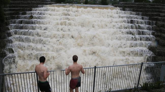
Meanwhile, the iconic Gooding Drive cows who were stranded on an ‘island’ surrounded by floodwaters have been saved from flash flooding.
They were moved to higher ground on Carrara Markets vacant land after a video posted by the Gold Coast Bulletin went viral.
1.30PM UPDATE: THREE evacuation centres have been opened on the Gold Coast with significant concerns parts of the city could flood following another deluge tonight.
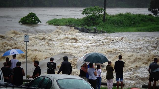
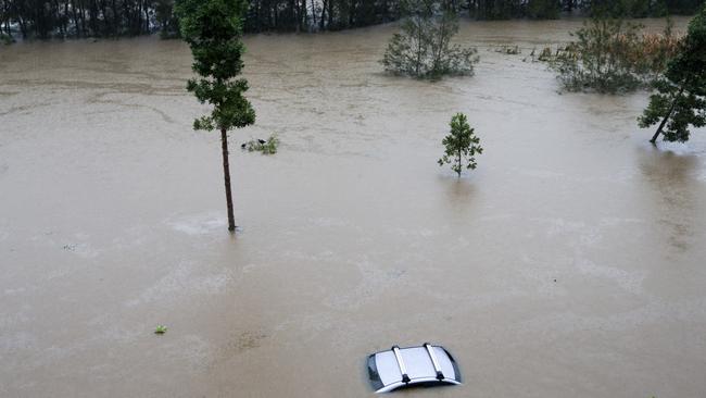
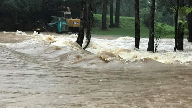
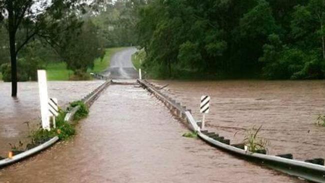
The peak of flooded rivers and canals on the Gold Coast from a predicted 500mm rain event will be in the early hours of tomorrow morning when swollen Nerang and Coomera rivers and creeks may break their banks.
The Gold Coast is bracing for a fierce deluge to strike later this afternoon with the flashpoint slated to be around 5-7pm.
Up to 500mm of rain could fall across 24 hours with an intense downpour expected this afternoon and wind gusts up to 125km/h.
The Tweed is also facing a flood emergency with evacuation warnings issued for 2000 residents along the Tweed River, south of Coolangatta.
Major flooding is forecast along the Tweed River at Murwillumbah this afternoon with river levels predicted to be similar to the 2001 and 2008 floods. Chinderah may also experience minor flooding.
Gold Coast City Council has opened three evacuation centres with Helensvale (37 Discovery Drive), Nerang (833 Nerang Southport Rd) and Robina (196 Robina Town Centre Drive) community centres open from 2pm.
An evacuation centre has also been set up by Family and Community Services at the Salvation Army North Point at Banora Point.
Mayor Tom Tate, providing the latest update, predicted the flooding would be at its worst after the 10pm high tide.
“I think 1am or 2am will be the extreme peak in our flood rise,” he said.
Councillor Tate said residents could also use four city libraries as “a place to keep safe”.
The focus of emergency teams in the afternoon will be to ensure detours are in place so patients can be taken around flooded areas near the Robina Hospital.
MIDDAY UPDATE: Up to 50mm of rain is expected to fall every hour through this afternoon and into tonight as the worst of ex-tropical cyclone Debbie lashes the Gold Coast.
The heaviest rain and wind gusts up to 125km/h are predicted to intensify from late today through to mid-evening with forecasters saying another 50mm per hour could smash the city, bringing the 24-hour total to 500mm.
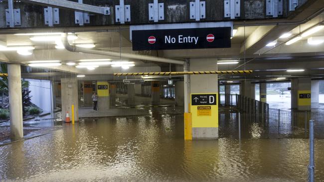
The intense deluge will add to a flood emergency already unfolding today after 300mm of rain fell across the Gold Coast in the early hours of this morning, putting dozens of roads underwater, including the M1.
The flood flashpoint will be at 10pm when a 1.66m high tide combines with swollen rivers already bursting.
“We are looking at some totals in excess of 400mm about the Gold Coast and Sunshine Coast hinterland and the Great Dividing Range,” BOM forecaster Matt Bass said.
Mr Bass said the rain was heavier and coming earlier than expected but the system is moving faster than originally thought.
“It may actually clear by midnight, or the early hours of tomorrow morning,” he said.
The State Emergency Service has doubled its Gold Coast crews since this morning as the weather conditions deteriorate.
“We have eleven crews out there at the moment, with four or five people in each,” an SES spokesman said.
“There are 118 jobs coming through on the Gold Coast. Most of those involve flooding. There has been some structural damage to some homes and some trees down.”
The calls are not specific to any suburb with crews working from Pimpama to the border.
“We have put the call out for everyone to come in,” the SES spokesman said.
Rain and wind will start to increase about 5pm with the peak of the downpour at 7pm.
11AM UPDATE: MAYOR Tom Tate has told Gold Coasters to stay at home and read Harry Potter as a major weather emergency unfolds across the city following a 300mm deluge overnight.
And the worst is yet to come with 500mm expected to fall as ex-tropical cyclone Debbie moves across the region this afternoon bringing wind gusts up to 125km/h.
Gold Coast schools, child care centres, beaches and shops at major shopping centres are closed and residents are being told to stay at home in an unprecedented move after the city was caught unaware by the true force of the weather system.
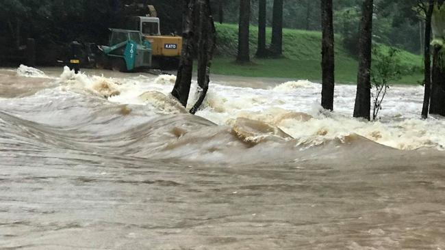
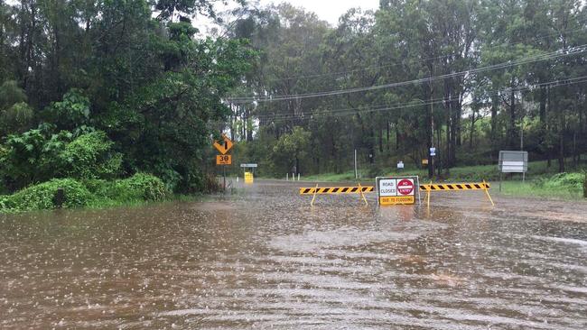
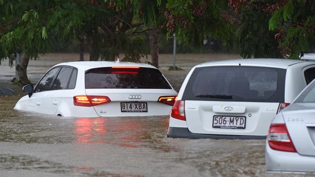
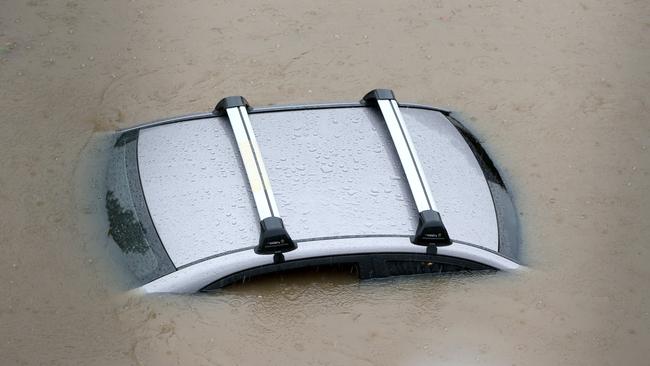
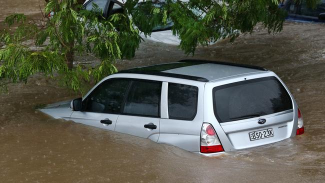
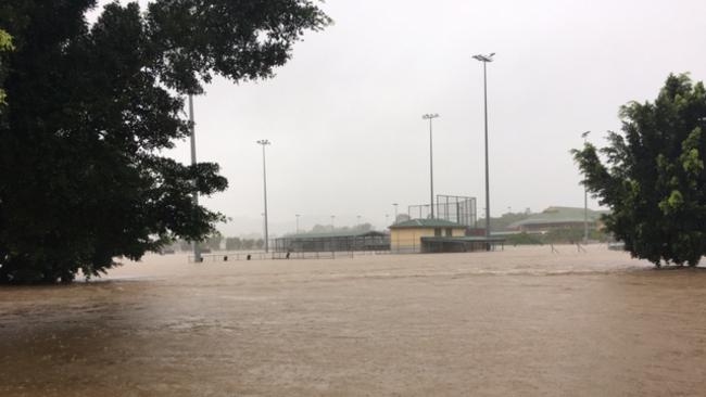
Parts of Tallebudgera, Currumbin, Carrara, Robina, Mudgeeraba and Helensvale are underwater and the M1 at Mudgeeraba is closed to ALL traffic due to flash flooding.
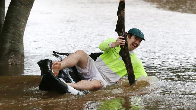
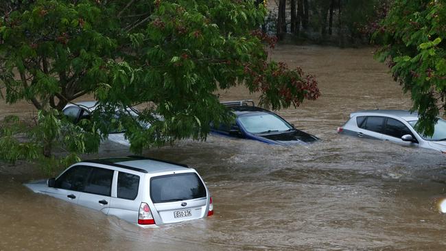
Mayor Tom Tate sent a blunt message to Gold Coasters caught playing in floodwaters with dozens of local roads underwater. Floodwaters are lapping at the roofs of cars in Robina.
“You’re a bloody idiot, get out of there. You’re not just potentially harming your own life,” he said.
“If you’re in trouble, SES personnel will come in and (it could) endanger their lives. Go and see a movie.
“Stay off the roads unless it is essential. Stay home. Go the library if you want to. My choice Harry Potter.”
Major rivers are on flood watch with the Coomera River set to break it’s banks shortly.
The Hinze Dam is turning into a raging torrent — already at 100 per cent before the deluge.
Little Nerang Dam is currently at 117 per cent and spilling. There is a significant flood risk for those downstream.
Mt Warning has also been closed.
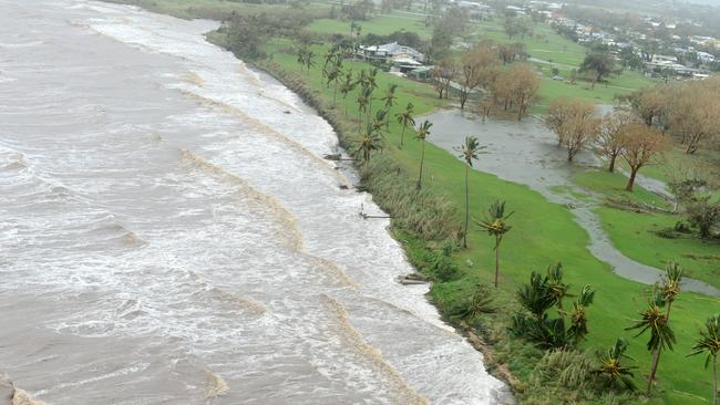
Greens are flooded and water is lapping at the back step of the Palmer Colonial golf course at Robina making the exclusive country club look more like island from the roadside.
SCROLL DOWN FOR SUBURB-BY-SUBURB RAINFALL
Bond University, Griffith University, Dreamworld, all Village Roadshow Theme Parks and the Animal Welfare League shelter have also been closed however Gold Coast Airport remains open but Virgin and Tiger have cancelled their flights.
Gold Coast University Hospital and Robina Hospital have cancelled all surgeries and outpatient appointments today.
All events at the Australian surf life’s saving championships at North Kirra have been cancelled for today and tomorrow, affecting thousands of competitors.
“If we can’t see you, we can’t save you.”
That was the message from Surf Life Saving Australia’s top officials this morning as they suspended competition indefinitely at the national championships on the southern end of the Gold Coast, unable to ensure the safety of competitors in the driving rain.
SLSA had risk assessors on the beach at North Kirra early this morning to determine whether the carnival should go ahead but with almost zero visibility on the water and conditions expected to deteriorate further, competition has been halted.
SLSA spokesman Ian Hanson said risk assessors were on the water early this morning and a decision was made to halt competition indefinitely.
“They had the risk assessors out on the water in IRBs and jet skis patrolling the beach area between Tugun and North Kirra and the major thing was there was zero visibility, they just couldn’t see in front of them,’’ Hanson said.
A further inspection will be made this afternoon but it’s expected competition will not resume until Saturday at the earliest, with a range of weather conditions combining to create unstable conditions, even for the best lifesavers in the country.
Fierce electrical storms, tidal surges, damaging surf and torrential rain are all expected to continue to hit the coast today and into tomorrow.
Water quality is also an issue, with stormwater spilling out of creeks to affect the competition area.
Police are urging business owners to think about allowing staff to leave early to avoid the most severe weather.
The Bureau of Meteorology warns conditions will ramp up this afternoon and throughout the evening with heavy rain, flash flooding and wind gusts greater than 125km/h.
The hinterland, which was already smashed by 300mm of rain overnight, is expected to cop the worst of the heavy rain this evening.
Police Commissioner Ian Stewart warned anywhere between 400-500mm of rain is predicted to fall on southeast Queensland.
“Do not underestimate the power of this rainfall,” he said.
The major message from the Mayor and Queensland Fire and Rescue Inspector Todd Murray at the first briefing on the impact on the Coast from Cyclone Debbie was for residents to stay inside.
He urged residents to buy batteries and listen to their radios for updated information.
Inspector Todd Murray from Queensland Fire and Rescue is hopeful no evacuations will occur.
“At this stage, no,” he told the Gold Coast Bulletin.
“The modelling, we have gone for a conservative approach. At this stage we are not expecting to evacuate anyone from any houses.
“We’re constantly monitoring that situation, if the need arises, we will do the warnings.
Councillor Tate said the flood modelling was being handled by Queensland Water.
“That will be all available by 4pm. We will know well in advance. Everything is well briefed, under control. It won’t be as bad as (Cyclone) Oswald the way I look at it.
“The beaches and repairs we have done, they will be intact. The winds are not as strong. So our (sea) walls and the like will be fine.”
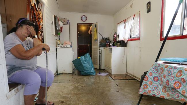
Emergency services performed a swift water rescue on Somerset Drive, Mudgeeraba after a man was believed to have been trapped in his submerged vehicle overnight.
Two other cars are also underwater while multiple vehicles in Robina have been flooded.
The SES has been called out to 81 jobs — largely for trees down and roof leakage.
The shocking weather conditions are challenging emergency service workers because the jobs are scattered across the Gold Coast.
Rather than being able to concentrate on one area like the hinterland in a storm event, State Emergency Service crews are being deployed from Pimpama to the border.
SES deputy local controller Leanne Woolard said six crews were attending to 81 jobs as more volunteers were arriving at the Southport depot.
“It’s scattered. There are jobs from Pimpama and Jacobs Well to the border,” she said.
“Most of it involves roofing and flooding. There is no one particular area that we have to worry about.”
Crews are helping residents with sand bagging. No families are being evacuated from properties yet.
SUBURB-BY-SUBURB RAINFALL DATA: (to 10.30am)
— Numinbah: 299mm
— Upper Springbrook: 288mm
— Tallebudgera Creek: 174mm
— Molendinar: 191mm
— Pacific Pines: 158mm
— Miami: 152mm
— Bonogin: 174mm
— Carrara: 157mm
— Evandale: 124mm
— Coomera Shores: 108mm
— Gold Coast Seaway: 105mm
— Biggera Waters: 159mm
— Clagiraba: 162mm
Motorists are being urged to be careful on the Pacific Motorway as water crosses the highway.
In an “unprecedented” move all schools from Agnes Water to the NSW border have been closed, including Catholic and independent schools.
Residents won’t get a reprieve from these conditions until tomorrow morning.
WHERE TO GET SANDBAGS:
City of Gold Coast has advised that residents may obtain sandbags from
their local hardware store.
Sandbags and sand can also be obtained from the following council locations:
Coomera — 232 Old Pacific Highway, Pimpama
Miami — 2 Ozone Parade, Miami8
Tugun — 56 Boyd Street, Tugun
Residents are encouraged to bring their own shovel if they wish to collect sandbags from the above locations.
If you require SES assistance, call 132 500
“We’ve had some very heavy falls in the Gold Coast area. We are expecting further heavy falls during the day,” the weather forecaster said.
Parents began being alerted about Coast schools being closed as roads become flooded in the hinterland just after 6.30am.
Silkwood School began sending out text alerts to parents and teachers around 7am as Crane Creek become flooded.
Further south, the Currumbin Valley State School was closed as flooded roads prevented access. All Saints closed it school just after 7.15am.
Others to close early included Springbrook State School and Numinbah Valley environmental centre.
The Gold Coast Bulletin was receiving reports that flooding had occurred at Southport State School.
Deputy Premier Jackie Trad at 7.30am announced all schools in the southeast would be closed.
Teachers are driving to some schools to help alert parents of the changes.
Beaches north of Burleigh were closed after 7.40am.
Winds of up to 56kmh were recorded at the Seaway with the Gold Coast hinterland smashed by heavy rain.
An incredible 284mm of rain was recorded at Numinbah Valley overnight with 183mm at Springbrook and 82mm at the seaway.
Gold Coast residents will start receiving a full update on flooded roads from 9am when Mayor Tom Tate is expected to hold a media conference.
Councillor Tate said the city was currently experiencing heavy rain and windy conditions.
“Our City’s Disaster Management Unit is ready. Everyone is urged to be aware of the likelihood of localised flash flooding. Some roads have been closed already,” he said.
“Some gale force wind gusts of up to 80km/h are possible along the coastline.
“You can prepare your home by securing any loose outdoor items, we urge you to do that this morning. If it’s flooded forget it.
“Forecasts predict a moderate to significant swell event on Friday. Lifeguards will continue to monitor surf conditions and forecasts relating to Gold Coast beaches.”
6.30AM: SES have been called out to 19 jobs this morning following reports of trees down, leaking roofs and flooding and will also been involved in the search for a person missing in the Hinterland.
Meanwhile police have been called to three incidents where people have attempted to drive through floodwater at Robina, Helensvale and Hyde Park.
Somerset Dr at Mudgeeraba is closed due to flooding.
Double the Coast’s average monthly rainfall is expected over the next three days, causing the weather bureau to put a flood watch in place stretching from North Queensland to Coffs Harbour in NSW.
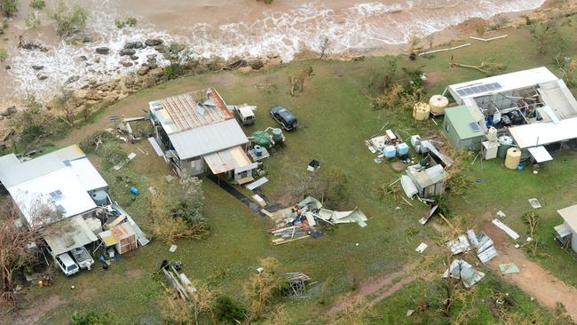
LATEST FROM CYCLONE DEBBIE CLEAN UP
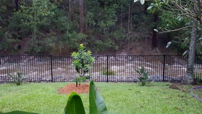
It comes amid concerns of flooding along the Nerang River with both the Hinze and Little Nerang Dams overflowing and the surrounding catchment already “saturated” by recent rainfalls.
“Seawater’s Flood Operations Centre has gone on alert and is closely monitoring
conditions and forecasts that may affect SEQ catchments,” Seqwater said in a statement.
“In the past seven days the catchment has received 42.6mm of rainfall, however up to 260mm is forecast to fall in catchment the next 48 hours.”
About 150mm of rain is expected to fall today, about 60m tomorrow and up to 19mm over the weekend according to Weatherzone forecaster Graeme Brittain.
“The rains are expected to be a blanketed event over a large area,” he said.
Mr Brittain said wild surf and strong winds are expected to follow the rain tomorrow with gusts up to 60km/h on the coast.

“Sustained winds up to 45km/h are expected with wind gusts up to 60km/h in exposed coastal areas,” he said.
Wild seas up to 3m could also be headed toward the city, whipped up by strong winds.
“Large swell is also forecast as well from the south east,” Mr Brittain said. “We think there will be period were waves could reach one to two metres, possibly three.”.
Ex-Tropical Cyclone Debbie is also expected to collide with a strong southerly front moving up the coast from the Tasman Sea.
This could cause even more violence offshore according to Bureau of Meteorology forecaster David Crock.
“There is a strong front coming from the south out of the Tasman Sea which could form into another East Coast Low when they interact,” Mr Crock said. “With the strong southerly winds there should be lots of swell about.”
Gold Coast City lifeguard superintendent Peter Ball said guards would monitor conditions and make a decision whether to close beaches if the storm moves in.
Meanwhile State Emergency Service Gold Coast duty officer Bret Fournier volunteers were on high alert.
“On the Gold Coast (flood waters) subside fairly quickly but last week we had a bit of rain and we’re going to get about 200mm more in the next few days,” Mr Fournier said.
He urged drivers to keep away from any flood affected roads.
“Forget about it, that’s the motto, but every clown seems to do it when it rains,” he said.
“We used to because we had vehicles equipped for it but we don’t even bother now, it’s too dangerous.”
Mr Fournier said people concerned about flooding at their property should look to hardware stores for protection.
“After the week of rain we’ve had we got calls from five people were looking for sand bags,” he said.
“We don’t supply them, Bunnings does.”

I found Qld’s best day trip – prepare to be blown away
Queensland has no shortage of great day trips but this may be the best of the best.

What to expect at this year’s Crafted Beer Festival
The excitement is brewing for the Gold Coast’s favourite frothy celebration, with beer lovers flying in from across the globe to crack a cold one and support the local scene. Here’s what you can expect.