
Tropical cyclone Ellie makes landfall as category 1 storm
A tropical cyclone has crossed the Australian mainland and is expected to bring major weather drama to one capital.
Environment
Don't miss out on the headlines from Environment. Followed categories will be added to My News.
A massive storm made landfall in Australia overnight as the monsoon season kicks into gear.
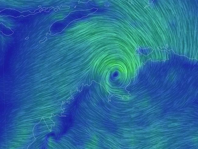
The Bureau of Meteorology (BOM) confirmed late on Thursday that a tropical cyclone had formed in the waters close to Darwin. While the city is not in the direct line of the cyclone it could still be hit by damaging winds and “intense rainfall,” the weather bureau has said.
Some areas could see as much as a quarter of a metre of rain.
Called Ellie, the category one storm made landfall in the Northern Territory at around 11pm on Thursday, south west of Daly River about 200km south of Darwin.
Tropical Cyclone Ellie is moving south over land, and continues to cause gales between Daly River Mouth and Wadeye. #CycloneElliehttps://t.co/AWJKLhQwBtpic.twitter.com/oiJrGDSup2
— Bureau of Meteorology, Northern Territory (@BOM_NT) December 22, 2022
As of 4am NT time Ellie remained a category one storm despite now being over land. It is expected to become a tropical storm by midday, Friday.
Despite moving through otherwise “sparsely populated” areas of the NT, the system’s centre passed close by Peppimenarti, an Aboriginal community of fewer than 200 people, at about 4am.
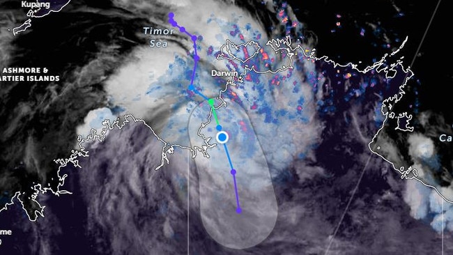
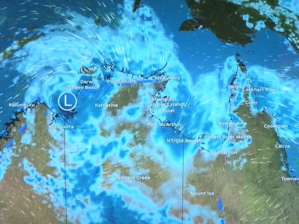
Latest tracking issued at 4am has it passing Timber Creek in the afternoon before slowly moving south west to towards a largely unpopulated part of the WA/NT border.
In a cyclone bulletin, the BOM said a warning zone was in place between Daly River and the WA border. Ellie is causing gales between Dundee Beach, 60km from Darwin, and Wadeye.
Sustained winds near the centre of the storm are around 75km/h with gusts of more than 100km/h.
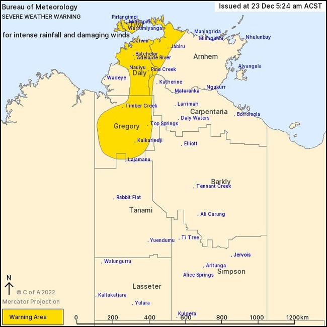
“Heavy rainfall is occurring over the Daly district and is likely to increase across the Gregory and adjacent east Kimberley districts throughout the day, and then extend further south over the weekend,” said the BOM.
Large than normal tides could lead to minor flooding between Dundee Beach and Wyndham on Friday.
Ellie is the first to make landfall on mainland Australia for the season.
The first of the season was tropical cyclone Darian which formed west of the Australian external territory of Cocos Keeling Islands in the Indian Ocean.
It continued west.
Severe weather warning for Darwin
The storm is heading south from the waters near Darwin but that doesn’t mean the Territory capital won’t be affected by both Ellie and the monsoon.
Dundee Beach, where gales have been recorded, is just 60km as the crow flies from the city.
The BOM has declared a severe weather warning for the city, Pine Creek and the Tiwi Islands.
Damaging wind gusts of up to 90km/h could hit on Friday and then steadily weakening.
Intense bursts of rainfall may lead to flash flooding over the western Top End with monsoonal showers and thunderstorms during Friday.
Twenty four hour rainfall totals between 160 and 200mm are possible, with isolated totals up to 250mm, stated the BOM.
Friday could see between 30-90mm in the city with the chance of a thunderstorm.
“Emergency services are keeping a close eye on the possible tracks of this storm and our local emergency management teams have activated their plans and are making the necessary preparations to see their communities safely through this event,” incident controller Kylie Anderson told the NT News.
Rain will continue into Christmas Eve in Darwin – up to 50mm is possible – with a lesser amount for Christmas Day.
Kununurra, in WA, could also see up to 90mm of rain and Friday with strong winds.
Damaging gusts of up to 120 km/h should be expected depending on Ellie’s path.
As a result, parts of the Kimberly, Tanami and Western Deserts and Sturt Creek have been put on flood watch.
Originally published as Tropical cyclone Ellie makes landfall as category 1 storm

Tsunami evacuations in South America as disaster averted in US, Japan
The threat of tsunamis has now spread to South America, while warnings were downgraded in Russia, Japan, and the US.
Read more

Quick-thinking surgeons save patient’s life
Gripping footage has shown how a team of quick-thinking surgeons reacted to the world’s biggest earthquake in 14 years.
Read more