‘Changing dramatically’: Signs Australia will move out of El Nino and back into La Nina
There is now as high as an 85 per cent chance of a huge gear change to Australia’s weather which could be exacerbated by years of La Nina.
Environment
Don't miss out on the headlines from Environment. Followed categories will be added to My News.
Well, that was brief.
Just six months after El Nino emerged, meteorologists have said the signs are all there for the climate driver to peter out within months – to be replaced by yet another La Nina.
La Ninas generally mean more rain and cooler temperatures for Australia.
If a La Nina does re-emerge it could be a worry as the ground of eastern Australia is still moisture laden from the last La Nina and that could exacerbate any flooding.
“Dramatic changes,” are occurring within the ocean to the east of Australia, Sky News Weather meteorologist Rob Sharpe told news.com.au.
“Everything is going according to plan in the Pacific Ocean for this to become a La Nina event.”
But the world’s meteorological organisations are not all in agreement.
Weak El Nino
El Nino and La Nina are the two extremes of the El Nino Southern Oscillation (ENSO) climate driver.
ENSO phases are defined by a combination of sea surface temperatures in a patch of the eastern Pacific Ocean called Nino3.4 as well as wind and air pressure measurements.
Warmer seas in Nino3.4 are a sign of El Nino, cooler seas La Nina.
El Ninos typically bring drier and warmer conditions particularly to Australia’s east. But this time around that didn’t go exactly to plan with heavier rainfall at times.
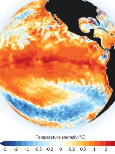
“We saw a fully-fledged El Nino during spring, but the atmosphere hasn’t been properly coupled through summer,” said Sky’s Mr Sharpe.
The ocean in Nino 3.4 has been warmer – an El Nino hallmark – but the atmosphere hasn’t been responding in the usual way, he said. Winds have been weaker than expected during summer, for instance.
“Therefore this has been a slightly shorter than usual El Nino event in my books.
“But El Nino tends to last less time than La Nina that can last up to three years as we found in recent years.”
‘Dramatic change’
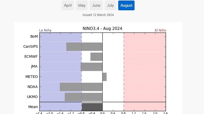
A key signal of La Nina is when the sea surface in the eastern Pacific cools to 0.8C below average for a prolonged period. The ocean hasn’t reached that point yet – but it’s getting there.
“The ocean is changing dramatically at the moment,” said Mr Sharpe.
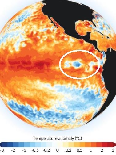
“Under the surface we’ve been watching a region of colder than usual waters move eastwards and get closer to the surface over the last couple of months.”
Some of that cold water has surfaced in the Pacific, west of Ecuador’s Galapagos Islands.
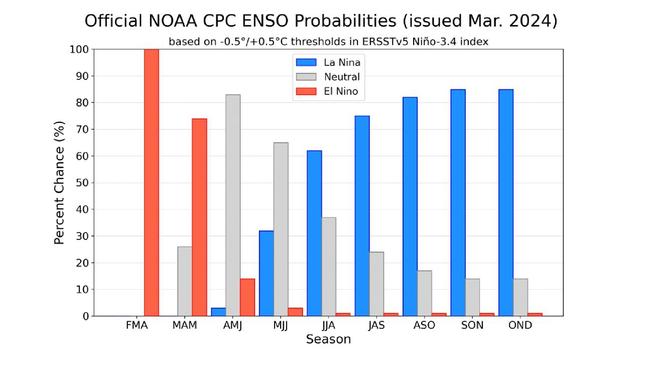
“La Nina is likely to develop in early winter,” he added. Sky News Weather has put the change of a La Nina at 85 per cent.
‘Unusually cold water’
The US’ National Oceanic and Atmospheric Administration (NOAA) is also bullish about an imminent La Nina.
Earlier this month, it stated that there was now a 62 per cent chance of a return to La Nina by June or August after a brief spell in ENSO neutral between April and June.
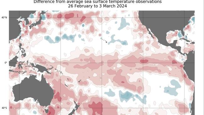
“A pool of unusually cold water has appeared at the surface of the eastern tropical Pacific Ocean, hinting that the foundations of a La Nina event may be lurking beneath the surface,” it stated.
That cold water region wasn’t visible in December.
However, global meteorological bodies have different benchmarks for climate drivers.
Australia’s Bureau of Meteorology (BOM) is more conservative with its ENSO declarations. It has a tougher criteria.
That’s what happened with El Nino, with the BOM declaring it active several months more after NOAA and the United Nations did the same.
Indeed, as of yet, it’s not actually forecasting a La Nina at all, only a move from El Nino to ENSO neutral. Although that forecast could change.
Earlier this month, it stated that while El Nino was still in play it was steadily weakening and was heading towards ENSO neutral conditions potentially around May.
But if you take an average of the world’s leading met bureaus, overall the prediction is for La Nina kicking in around August.
La Nina effects
During LA Nina, cooler sea temperatures in the eastern Pacific push trade winds westwards which in turn moves warmer waters to Australia’s east coast. That creates more clouds and more clouds makes more rains.
“Wetter than usual weather is likely for much of Australia through winter and spring – particularly for northern, central and south eastern inland Australia,” said Mr Sharpe.
And the rain could come earlier than usual.
Western Australia is less affected by ENSO.
“The question really is – will the atmosphere respond to the cooling ocean properly?”
Or in other words, if we’ve just had a half-hearted El Nino could we be in for a half-hearted La Nina as well?
In some places even a fully fledged La Nina may not bring much extra rainfall.
“For Sydneysiders, for example, La Nina is not a guarantee of wetter than usual weather as historically La Nina has only had a small influence on Sydney’s rainfall,” Mr Sharpe said.
“However, it was part of the reason why Sydney had a record wet year in 2022.
“Flooding is a much greater concern than it was during the first La Nina event we had a few years ago because the landscape is much wetter and dams are much fuller.”
Mr Sharpe also said that global warning played a role.
“For every degree of warmth in the air, the atmosphere can hold a 7 per cent more moisture.
“This means that when it rains it’s more likely to pour.”
Australia may have only just got used to El Nino but we could swing back to La Nina in just a few months.
Originally published as ‘Changing dramatically’: Signs Australia will move out of El Nino and back into La Nina


