Moruya community split over bypass options amid cost concerns
With both major parties touting new investments in road infrastructure, one town on the state’s south coast is split over which route a new bypass should take.
Community leaders have blasted plans to deliver a new bypass past threatened wetlands, as locals remain divided over the preferred course for the “unwanted” road.
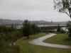
The State Government unveiled three possible routes for the new Moruya bypass in April after first announcing the project under then-Premier Gladys Berejiklian in 2019.
The report includes Transport for NSW’s previously preferred route for the new road – known as the orange route – which had faced pushback last year, prompting the presentation of two additional options.
The project comes as both major parties claim successes in road and infrastructure projects before the next Federal Election, with new investments promised for bypasses in Nowra and Milton.
But, for some locals, the project is neither wanted nor needed, and could jeopardise precious local ecosystems and businesses just now recovering from the Covid pandemic.

A spokesperson for the Moruya Community Association said TfNSW’s favoured route was the longest, most expensive, and most environmentally damaging option, and was unconvinced the agency was not still pursuing it despite the release of proposed alternatives.
Unlike the purple option preferred by the local community group, the orange route would likely require houses to be demolished, and would encroach upon protected wetlands, according to the spokesperson.
“Out of all the options, it’s the one the government wants, even though 20 odd homes will be destroyed on the southern side of Moruya,” they said.
“For most of the route it will be a four lane, 5m high, 9km long bridge suspended over the floodplain, north and south. The pylons which support it will need to be 30m deep, in order to reach bedrock and there will be approximately 640 of them.
“To achieve this engineering feat, the bridge will take out 44ha of native forests, which are home to ecologically threatened communities, including black glossy cockatoos, bandicoots, sugar gliders.

“They’ve picked the most destructive route possible to get their trucks moving through, because if they chose another path, it will slow them down.”
Under measurements jointly compiled by the community group and the Moruya Bypass Action Group, the preferred orange option would actually entail a 3.5 minute longer wait time for hospital arrivals, and could cost as much as $1 billion more to build.
Also advocating for the purple route, the Moruya Bypass Action Group claim TfNSW had been contacting landholders since July 2021 to negotiate specific route alignments through their properties and, in some cases, property acquisition.
“What was the point of the community consultation if TfNSW already had a definite route in mind?” the group’s website states.
“Why have an options report when in fact there never were any options as far as TfNSW was concerned? This whole process looks like a cynical exercise in going through the motions of consulting the community without giving them sufficient information and actually listening to what they have to say, let alone acting on it.”
The group also called into question the cost of the project.
“TfNSW’s director for the Princes Hwy upgrade program indicated that the budget for the section of highway from Nowra to the border was $1.5 billion,” the website states.

“We do not understand why half of that budget is being allocated on bypassing Moruya. We also questioned the priorities of the NSW Government when only $260 million has been allocated to a new hospital that will service the entire Eurobodalla Shire and yet $750 million is allocated to an 8km bypass around Moruya.
“Particularly when there are shorter, less expensive and less destructive bypass options available.”
For both groups, a lack of consultation had clouded the project. They claim that community and business leaders were not informed of the future bypass before its announcement.
“A closed-door meeting in October 2021 didn’t bring in any community participants, only government institutions like NSW Health and local council,” the spokesperson said.
“NSW Transport unilaterally decided despite the original purview being just a bypass, they would extend it and make it a highway realignment as well … they decided to make the project bigger without community consultation, crossing even more floodplain.”
The spokesperson claimed traffic issues in the town were only present during the tourist season, and that the preferred route would hurt local businesses by allowing motorists to avoid the area almost entirely.
“People are just going to just fly right past Moruya and not even know it exists,” the spokesperson said.

“We’re just saying ‘let’s have a bridge just like the existing bridge but a bit further up’, and you can travel there at 70km not roaring past at 100km.
“People can see Moruya and turn off to it if they want to see it.”
The community-led organisation recently launched an informational campaign replete with video explainers and a multimedia website, explaining to residents the pros and cons of each option.
But, that hasn’t convinced all residents, nor organisation members.
In the organisation’s Facebook group, member Jess Pendergast said the purple route championed by the organisation “did not make sense”.
“The industrial area access is not addressed, it is getting busier and harder to pull out onto the highway,” she said.
“What’s the point of a bypass if it’s reduced to 70km an hour.
“Speak to business owners at Bega and Berry, their businesses are booming after the bypass. People can go into those towns and get parking now.”
David Whipp said: “Purple route nullifies the meaning of a bypass. It would eventually be like Batemans Bay and Nowra: 70k in the middle of town.
“The yellow route is what a bypass should be – out of town with off ramps at either end.

“The people pushing the purple route are very short sighted or have a vested interest.”
Dean Thomas said: “The yellow route is pretty much all solid ground and makes use of roads and easements already in place.
“The purple route is too close to town and long term won‘t stop the traffic back up that happens at the end of each holiday period of people heading north trying to get home.”
A spokesperson for Transport for NSW said the orange route was decided in May of last year as the preferred corridor as it was found to best meet the project outcomes on balance across all goals and objectives including safety, resilience, liveability, connectivity and sustainability.
“Corridor options that were closer to town were considered to have an increased adverse impact on flooding, noise and visual amenity,” the spokesperson said.
“During the consultation period on the orange route, TfNSW received wide-ranging feedback. As a result, consultation has been reopened to provide further opportunity for feedback on three short-listed corridors – purple, yellow and orange.”

The spokesperson said the need for a bypass at Moruya was determined following investigations including an analysis of traffic volumes on the Princes Highway between 2013 and 2019.
“The analysis showed that approximately 8000 vehicles passed through Moruya each day and 11 per cent of this traffic was heavy vehicles,” they said.
“The average crash rate and number of incidents resulting in serious injury on this section of road is higher than the NSW average.
“Transport for NSW acknowledges that all three short-listed corridors have varying levels of impact to wetlands. The Biodiversity Survey Report released in November 2021 outlines some of these impacts.
“As the project progresses, we will continue to carry out further environmental assessments to ensure we avoid, remedy or mitigate any impacts during the design and construction of the bypass.”
The spokesperson said there is no confirmed construction costs at this stage of the project.
Community consultation on the proposed route will close in June 2022.