
Flood watch: Fresh evacuation warnings issued for Sussex Inlet, St Georges Basin
While floodwaters have started to recede in some areas of Sydney, the South Coast and the Illawarra are not in the clear just yet with fresh evacuation warnings issued for St Georges Basin and Sussex Inlet near Jervis Bay. Find the latest here.
The South Coast News
Don't miss out on the headlines from The South Coast News. Followed categories will be added to My News.
While floodwaters have started to recede in some areas of Sydney, the South Coast and the Illawarra are not in the clear just yet with fresh evacuation warnings issued for St Georges Basin and Sussex Inlet near Jervis Bay.
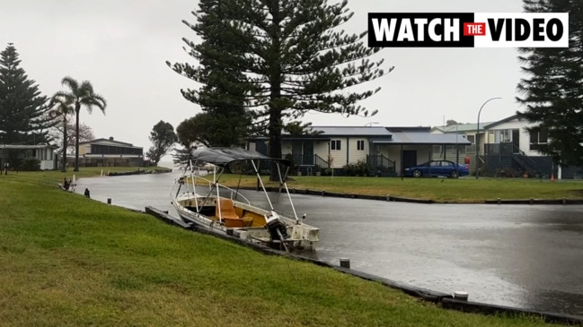
NSW SES advised residents around 4pm on Monday that moderate flooding could inundate homes in low-lying areas on the high tide.
Affected areas in Sussex Inlet include:
• Wunda Ave
• Ellmoos Ave
• Jacobs Dr
• Poole Ave
• Riverside Caravan Park
• Badgee Caravan Park
• River Rd
• Cater Crs
• Banksia St
• Fairview Crs
• Nielson Ln
• Laguna Lodge Waterfront Accommodation
• Riviera Caravan Park
Areas of St Georges Basin advised to prepare to leave include:
- Sanctuary Point
- The Park Dr
- Mountains St
- Larmer Ave
- The eastern side of Fairway Dr
- The eastern side of Roulstone Cr.
- St Georges Basin Foreshore
- Walmer Ave
- Old Erowal Bay
- McGowen St
“Further rainfall is forecast during Monday into Tuesday, which may cause further river level rises and prolonged flooding at St Georges Basin,” according to the Bureau of Meteorology.
“The St George Basin at Island Point Rd is currently at 1.23 metres and steady, with minor flooding (and) may reach the moderate flood level (1.50m) Monday night.
“The Sussex Inlet is currently at 0.92m and rising, with minor flooding. The river may reach the moderate flood level (1.20m) around 11:00pm Monday on the high tide.”
The Shoalhaven River at Nowra reached 2.95m shortly after midday on Monday, but remained steady, with minor flooding.
The river level was expected to likely to peak near 3.00m during Monday afternoon.
The Shoalhaven River at Terara is currently at 2.74 metres and rising, with minor flooding, and is likely to peak near 2.8m.
The warnings come as forecasters predict continued heavy rainfalls in coming days.
“Although the rain rate should decrease through Sydney and the Illawarra overnight, we are expecting continued rain along the NSW coast for the remainder of the week,” the Bureau of Meteorology's manager of decision support services Jane Golding said on Monday.
“That means the catchments are not drying out.
“So, the flood risk does remain.”
Along the Illawarra coast, Wollongong received just 30mm of rain up until 4pm on Monday – an amount still equivalent to the whole of July 2021 – down from the 183mm recorded the day before.
Further south, Nowra recorded 93mm of rain on Monday, just down from 101mm recorded on Sunday and a high of 125mm on Saturday.
In July 2021, the South Coast town received just 22mm.
Strong winds of more than 30km pummelling the coast will persist in coming days, with warnings remaining in place for large and powerful surf conditions which pose risks to marine operators, surfers, and coastal and rocker fishermen.
Earlier on Monday, residents at three retirement villages and a motel in the Lake Illawarra area have been ordered to prepare to evacuate.
The Jetty’s By The Lake Lifestyle Village, Oaklands Lifestyle Village, South Pacific Park Village, and the Oasis Resort and Caravan Park were advised by NSW SES to prepare to leave at around 9am on Monday.
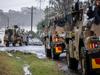
The warnings come as an east coast low, the same weather event that wreaked havoc in March, makes its way across Australia’s coastal regions, triggering more than 70 evacuation orders, according to NSW SES.
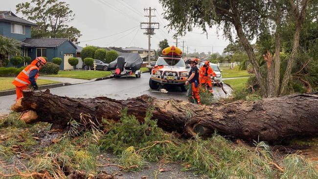
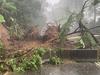
While the worst of the weather has been felt across Greater Sydney over the weekend, intense rainfall and high winds have cause mudslides in the Illawarra and closed roads in the Shoalhaven.
In Ulladulla, emergency services said that Yadboro, Brooman, and Shallow Crossing bridges remained isolated, with a second rise in the Clyde River expected with coming rains.
“Porters Creek Dam is still overtopping,” the Ulladulla SES said on Monday.
“Since yesterday, more rain has fallen in the north than in south.”
- Fisherman’s Paradise: 71mm to 6am
- Lake Conjola: 31mm
- Ulladulla: 23mm
Only days after an important route into the Kangaroo Valley was opened after it was closed by a landslide in March, the Shoalhaven City Council closed the Upper Kangaroo River Rd east of the town.
“Council closed Upper Kangaroo River Road at 11am, July 2 after inspections revealed worsening conditions at the landslip site,” according to a council spokesperson.
“Access will be for residential emergencies only and limited to a maximum of 3 tonnes.”
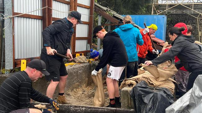
Further north, NSW SES units from Nowra, Wollongong, Kiama, and Shellharbour joined units from Ulladulla in emergency callouts across the Illawarra.
Over the weekend, NSW SES Wollongong Unit received 224 calls for assistance.
The nearby Shellharbour unit received an additional 134 call-outs.
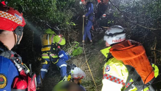
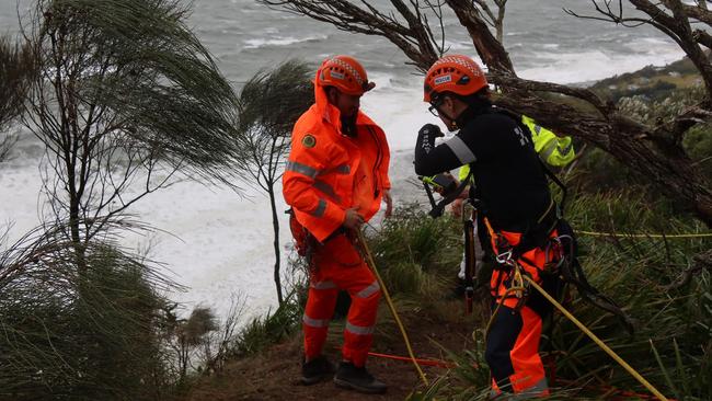
On Saturday, SES volunteers conducted a “complex” multi agency rescue in Otford, south of Sydney, with NSW SES Sutherland Shire working closely with Vertical Rescue operators from the Wollongong unit.
The Illawarra Police Rescue Squad also aided in the operation, alongside NSW RFS as well as NSW Ambulance, who helped evacuate a patient from down an embankment.
The rescues carried out by volunteers have been made challenging by high rainfall across the region.
On Sunday, Wollongong recorded a massive 183mm of rain.
The same month last year, the city receive just 30mm.
Further south, Nowra received 125mm on Saturday and at least 101mm on Sunday.
Those rains closed nearby amenities over the weekend, including the Comerong Island Ferry and the Tilbury Cove walking track, near Orient Point.
As for closed roads, they include:
Shoalhaven
Upper Kangaroo Valley Rd – closed
Bunkers Hill Rd – closed
Wattamolla Rd – closed
Mt Scanzi Rd – restricted
Woodhill Moutnain Rd – closed
Browns Mountain Rd – restricted access
Hockeys Ln – closed
Meroo Rd – closed
Queen St – closed
Coolangatta Rd- closed
Albert St – closed
North St – closed
Hay Ave – closed
Bolong Rd – closed
Hanigans Rd – closed
Scenic Dr – closed
Berry St – St Anne St – closed
Berry St – closed
Hillcrest Ave – closed
Quinns Ln – closed
Comerong Island Rd – closed
Albatross Rd – water over road
Millbank Rd – closed
Worrigee Rd – water over road
Burrier Rd – closed
Greens Rd – closed
Haiser Rd – closed
Keith Ave – closed
Fraser Ave – closed
Greens Rd – closed
Suffolk Rd – closed
Dr Loralyn Ln – closed
Albion Centaur Ave – closed
Maddens Rd – closed
Illawarra
Cataract at Appin Rd cross M1 Princes Motorway – closed with fallen tree
Taylor Rd, Albion Park – closed between Terry St & Hamilton Rd
Swamp Rd, Dunmore – closed

‘A bit over’: Business owner’s ‘enormous’ speed exposed
A South Coast businesswoman, who boasts a “poor” traffic record with six previous suspensions, has been busted speeding almost 50km above the limit on a busy highway, telling responding police she “was a bit over”.

Woman allegedly stabs partner in violent domestic assault
A woman accused of stabbing her partner in an alleged domestic violence incident on the NSW South Coast has fronted court for the first time days after the incident.