
Heavy rainfall over the Mid-North Coast has triggered moderate flooding along the Nambucca River at Bowraville.
The situation is being closely monitored by the SES, with rainfall forecast for the remainder of the day.
"The Nambucca River at Bowraville is estimated to have peaked around 5.9m this morning, with moderate flooding," the SES has advised.
"It is likely that roads to and from Bowraville will be closed if the river exceeds 6.5m at the gauge, isolating Bowraville."
Authorities have warned High St may close at Lanes Bridge, as well as a possible closure on Wilsons Rd, which could affect access to Macksville depending on tidal influences.
Residents of low-lying areas near the river should keep an active watch on the flood waters and stay in contact with neighbours.
Meanwhile farmers close to rivers and creeks are being urged to monitor livestock, pumps, and other equipment.
"Waste and chemical containers should be located well above predicted flood levels," SES said.
No river level observations are currently available for Bowraville.
Hunter, Mid-North Coast flood watch: NSW SES preparing for all scenarios
Communities from the Hunter to the state’s Mid-North Coast and beyond are on flood watch once again, as NSW SES respond to calls for help across the region
Homes and businesses stretching from the Hunter to the state’s Mid-North Coast are on a nailbiting flood watch for the third time this year — as State Emergency Services volunteers were called out to 600 requests for assistance and 51 flood rescues overnight across NSW.
On Thursday, NSW SES Commissioner Carlene York forecast the risk of flash flooding, heavy rain and thunderstorms across the state’s northwest, with volunteers “preparing for all scenarios”.
“Riverine flooding (is) possible from Thursday along the coast from the Northern Rivers, Mid North Coast and Hunter catchments,” the commissioner said.
“The Bureau of Meteorology anticipates moderate to heavy rainfall and possible severe thunderstorms on Thursday into Friday, combined with saturated soils about the state’s east, bring an increased risk of significant flash flooding.
“Gusty winds with thunderstorms may bring down trees and powerlines about the northeast.”
The warning comes after reports a brave Hunter cop entered dangerous flood waters on Thursday to rescue three people from a partially submerged car – including a woman who had become trapped on the outside of the vehicle and a four-year-old boy.
NSW SES deputy state controller, Chief Superintendent Dallas Burnes, said the SES was “operational” across the whole state on Friday morning.
“We have significant flooding, moderate flooding on nine river systems across the state,” he said.
NewsLocal reporters across The Hunter and Mid-North Coast will provide rolling coverage across the region.
MORE TO COME
Updates
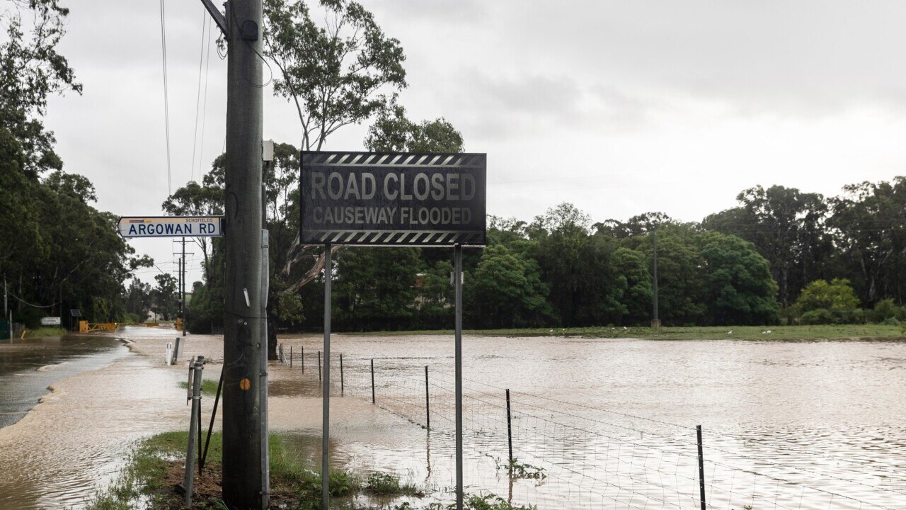
Roads to be closed at Bowraville
Coffs man flees sinking car
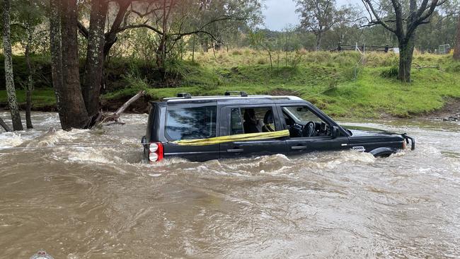
Dramatic images have emerged from Coffs Harbour after a man fled his sinking car in Upper Orara.
SES’s Ian Horncastle said a triple zero call came in yesterday after the vehicle left the roadway into a submerged creek area.

Authorities arrived on the scene to find the driver safe on higher ground after he managed to escape his vehicle without injury.
"As you can see from the photos, it didn't take long before the flowing water went right over the vehicle," Mr Horncastle explained.
"So he's a very lucky man."
More storm jobs were carried out earlier this morning, with medical supplies being transported to Nana Glen, which is currently isolated.

Mr Horncastle confirmed there were also thunderstorms targeting Woolgoolga.
"We're watching a cell that's coming down from Queensland, which has really targeted the Gold Coast dramatically this morning," Mr Horncastle said.
"The wet weather is easing for now, but that cell is showing significant rainfall and it's coming down from Byron now."
"So we're watching that as it falls our way – there's nothing too concerning here at the moment, but we're not going to have a sunny day at all."
Flood rivers reaching peaks
The Mid-North Coast's Georges Creek is near its peak according to NSW SES representatives.
Meanwhile, the Macleay River at Bellbrook expected to reach a minor flood level peak of 4.5m at around 1pm, while the Macleay River at Kempsey is forecast to reach a minor flood peak level of 4.8m on Saturday morning.
"The river level may reach around 4.8m Saturday morning with minor flooding," a SES volunteer advised.
"The peak prediction for Kempsey will be made once the flood peak is observed at Bellbrook."
Meanwhile, the Macleay River at Georges Creek was near its peak at 7.43m at around 7am on Friday morning, with minor flooding, with prediction of decreasing flood levels by this afternoon.
A number of bridges may close at Bellbrook and surrounding areas, including Bellbrook Bridge (closed), Turners Flat Bridge (may be closed), Toorooka (may be closed), and Sherwood (may be closed).
Water is starting to impact low lying areas, roads, and bridges in Kempsey, with Queen St now closed.
River levels rising
Moderate rainfall over the Bellinger catchment on Wednesday and Thursday has caused river level to rise further north.
Minor flooding has been reported at Thora, with moderate flooding (at 4.3m) possible this morning.
NSW SES volunteers said "The Bellinger River at Thora peaked at 3.98 metres around 02:30 am Friday, 23 September and is currently at 3.93 metres and falling, with minor flooding."
Road closures are also a possibility, with NSW SES representatives forecasting Darkwood Rd at Hobarts Bridge, Joyces Bridge, and Leans Bridge "may close".
The SES have warned minor flooding is likely at Bellingen from early today.
"Rainfall forecast for Friday may result in further rises," the SES spokesman advised.
"The Bellinger River at Bellingen may reach around 4.4m this morning, with minor flooding.
"Farmland downstream of Bellingen may begin to be inundated."
Yesterday’s marine wind warnings for the Coffs and Macquarie coasts have since been cancelled, but a severe weather warning is still being issued for the Northern Rivers and Mid-North Coast.
Mid-North Coast on alert
As of 2am on Friday morning, Georges Creek on the Mid-North Coast was experiencing minor flooding.
NSW SES representatives said moderate to heavy rain in the Macleay catchment yesterday has caused river levels to rise.
It's expected the Macleay River at Georges Creek may peak near 7.7m early this morning.
"Flood water may start to impact low lying areas, roads, camping areas, and causeways in the upper Macleay," the SES representative advised.
"Should river heights continue to rise, residents need to consider the impact of potential isolation."
Meanwhile, rivers in Bellbrook and Kempsey are expected to remain below the minor flood levels. The SES has warned these Lower Macleay communities would be isolated if the river exceeds 5.7m at Kempsey.

‘F**ken muppet’: Convicted drug dealer’s DV terror
A convicted drug dealer has admitted to violently beating his partner, abusing her relentlessly and repeatedly breaching an AVO by calling her mother while in jail.

Inquest call 50 years after mystery disappearance of Sydney woman
A tormented family is calling for an inquest into the mystery disappearance of a young Sydney woman 50 years ago — they believe she may have been murdered.