
Northern Rivers, Mid-North Coast, Hunter, Dubbo: Rain, wind, thunderstorm, flooding advice
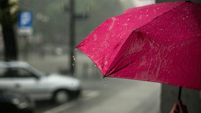
A resident was trapped knee-deep in water in their home on the Coffs Coast, as a widespread rain event continues to smash down on much of the NSW North Coast. Here’s the latest.
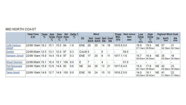
Mid-North Coast
Don't miss out on the headlines from Mid-North Coast. Followed categories will be added to My News.
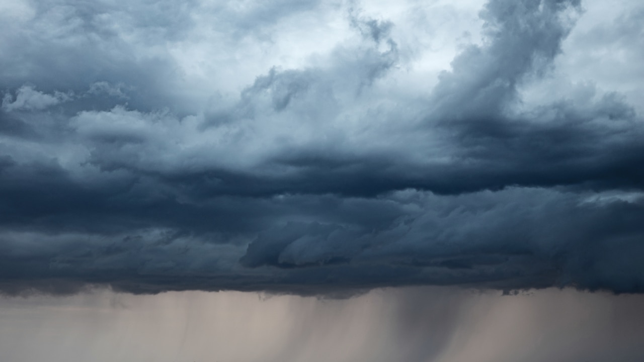
On Queen Elizabeth’s national day of mourning, it’s tears falling from above - in the form of widespread rain across much of NSW - that has residents on edge.
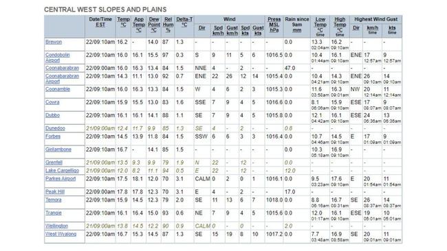
Scores of river systems around the state are either at flood advice or watch levels, with inland cities like Dubbo the hardest hit so far.
Inland
The Bureau of Meteorology (BOM) has issued a major flood warning for the Macquarie River at Wellington, Dubbo, Narromine and Warren.
In the latest advice (September 22), renewed river rises are occurring along the Macquarie River and its tributaries, with “major flooding likely to continue at Warren for several days” and “minor flooding occurring at Wellington and Narromine”.
On the back of rainfall yesterday, it has triggered minor flooding along the Bell River at Wellington.
The BOM says minor flooding is possible along the Macquarie River at Dubbo this afternoon.
At 4am today, rising river levels were recorded for this body of water, measuring 4.07m at Dubbo.
To the coast
While parts of inland NSW have already copped a bucketing, concern is now growing for the Mid-North Coast, where the rain system is expected to impact, particularly from Coffs Harbour to Kempsey.
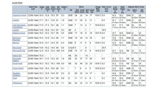
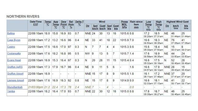
BOM has now released a flood watch for NSW’s Northern Rivers, Mid-North Coast and Hunter regions.
This is early advice for possible flooding within these catchments.
“A low pressure system within a trough over northeast NSW is forecast to deepen tonight before moving into the Tasman Sea later Friday,” the BOM advised.
“Moderate to heavy rainfall is forecast for the Northern Rivers, Mid-North Coast and Hunter districts during Thursday and Friday.”
Catchments likely to be affected include:
- The Coffs Coast
- Tweed and Rouse rivers: minor to moderate flooding
- Brunswick River and Marshalls Creek: minor to moderate flooding
- Wilsons River: minor to moderate flooding
- Richmond River: minor flooding
- Orara River: minor flooding
- Bellinger and Kalang rivers: minor flooding
- Nambucca River: minor flooding
- Macleay River: minor flooding
- Hastings River: minor flooding
- Camden Haven River: minor flooding
- Manning and Gloucester rivers: minor flooding
- Goulburn and Upper Hunter rivers: minor flooding; and
- Wollombi Brook and Lower Hunter River: minor to moderate flooding.
Heavy rainfall, which may lead to flash flooding, is expected to develop around the Mid-North Coast and Northern Rivers districts during the day, with the BOM expecting it to continue into Friday morning.
“Six-hourly rainfall totals of 60 to 80mm, with isolated falls to 120mm are possible,” BOM advises.
“Twenty-four hour rainfall totals of 80-120mm, with isolated falls to 200mm are possible.”
Severe thunderstorms with localised heavier rainfall are also expected over the Northern Rivers this afternoon and into the evening.
Wind
BOM has also released marine wind warnings for the public holiday and tomorrow.
Strong winds are expected today on the Byron, Coffs, Macquarie, Hunter, Sydney and Illawarra coasts.
Weather advice has been updated to cancel the wind warnings for Batemans Coast.
Meanwhile, strong winds are expected to continue tomorrow on the coasts of Byron, Coffs and Macquarie.
What’s causing this?
The BOM has advised “coastal catchments are wetter than average for this time of year”.
So where did this weather pattern come from, and what’s it all about?
We spoke with SES’s Ian Horncastle to find out.

The wet weather, while widespread, won’t last too long.
“A low pressure system, associated with crossing of the state, is bringing rain and some thunderstorms over the next 24-48 hours,” Mr Horncastle said.
“This system will move east as it reaches the Tasman Sea today, with it weakening tomorrow and over the weekend.
“It’s coming from the Indian Ocean and across NSW.”
He confirmed the current wet weather isn’t directly related to La Nina.
The Coffs SES team has been hard at work over the past 24 hours, with Mr Horncastle detailing a number of jobs the local volunteers have assisted with.
“We’ve stood up a number of in-water rescue operators in case they’re required for flash flooding, which is predicted,” he said.
“We have three storm crews out in the field, and we’ve had a number of jobs since 8am this morning.
“We did a rescue where a person was trapped in their home in knee-deep water, and another one where a vehicle has left the side of the road into flood waters.”
Mr Horncastle said locals should remains calm through these wet few days.
“Localised flash flooding is always a concern, but it’s only going to be for a short period of time,” he explained.
“It’s only over the next 24 hours that we’re expecting the heavy rainfall to continue, which could bring about that flash flooding.
“We’re urging people to be mindful on the roads, especially in the Nana Glen and Glenreagh areas, as that’s where we had a job this morning.”
Remember if it’s flooded, forget it.


Join the conversation

‘Who are these kids?’: Moment child abuse material uncovered
A court has seen vision of the arrest of a man on the child protection register found to have almost 150 images depicting child abuse on his laptop.
Read more

Group 2: Big guns clash in early season blockbuster
There was plenty of desperate defending as two of the competition’s heavyweight sides clashed in Group 2.
Read more