
Northern beaches: The top 10 hidden natural ‘gems’ revealed
Sydney’ northern beaches is renowned for its natural beauty. But there are some spots, off the tourist trail, which are worth highlighting. Here’s 10 of the hidden gems.

Manly
Don't miss out on the headlines from Manly. Followed categories will be added to My News.
From cascading waterfalls to ancient Aboriginal sites and pools filled with “mermaids”, Sydney’s northern beaches is dotted with places of spectacular beauty — which are not on the usual tourist trail.
Here are 10 of the region’s “hidden natural gems”.
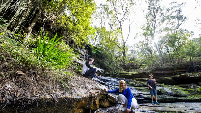
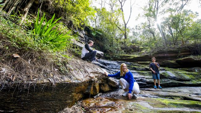
MERMAID POOL: MANLY VALE
This beauty spot, surrounded by suburbia and just 400m downstream from Manly Dam, has been the focus of a concerted community effort to bring it back to its natural glory thanks to the hard work of the Save Manly Dam Catchment Committee.
The pool on Manly Creek, just off King St at Manly Vale and fed by a beautiful waterfall, had become a dumping ground and ended up choked by weeds over the decades.
It was once a popular swimming spot with local historians suggesting it got its name during the late 1920s and early 30s when naked women were seen in the pool.
They came from a camp at nearby Allambie set up for people who had lost their homes in the Great Depression.
Now thanks to the “Return of the Mermaids” clean-up project, the site is looking fantastic again.
THE BIBLE GARDEN: PALM BEACH
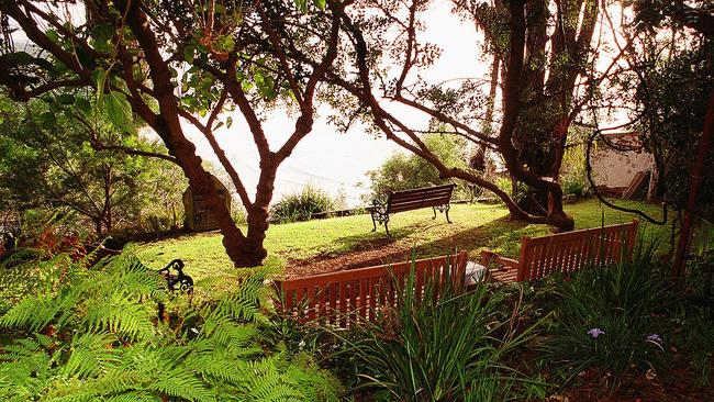
In the 1960s a devout Christian established The Bible Garden in Mitchell Rd where he had every plant — 140 species — mentioned in the Old and New Testaments.
The former Pittwater Council became its owners in 2006 but, by 2010, the garden had fallen into disrepair with only 10 per cent of the original species left.
Then the community group, Friends Of The Bible Garden, worked to re-establish the garden, which was replanted with about 90 species.
NSW governor Marie Bashir reopened the restored Bible Garden in September 2012.
Biblical plants include iris (Hosea, chapter 14, verse 5); box hedge (Isiah, chapter 41, verse 9) and coriander (Samuel, chapter 4, verse 2).
The garden, now owned by Northern Beaches Council, has sweeping vistas of Palm Beach and is popular for weddings, christenings and naming ceremonies.
Friends of the Bible Garden describe it as a “quiet, contemplative, Christian garden made up of a series of gently descending, intimate grassed terraces that lead down to a viewing area providing spectacular views”.
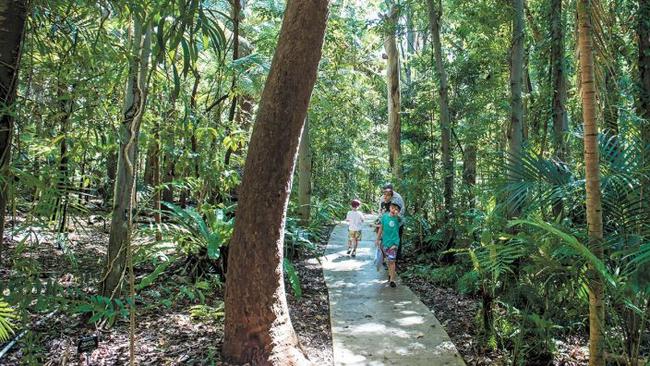
ABORIGINAL ENGRAVINGS: BANTRY BAY
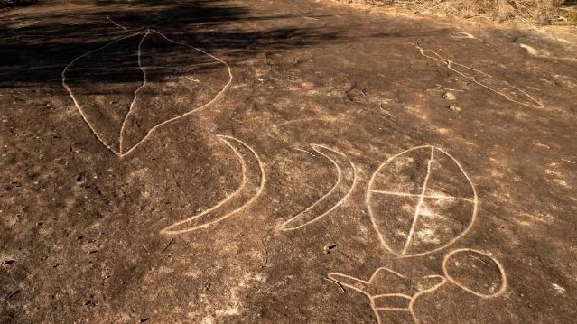
Not far off the busy Wakehurst Parkway at Frenchs Forest is one of Sydney’s biggest Aboriginal engraving sites with close to 100 ancient figures carved into the flat sandstone rock platform.
The site is 400m along the Engravings Track, which begins at the southern end of Bantry Bay Rd, not far from a new residential estate.
They have been described as the “most extensive single group of carvings in the Sydney metropolitan area”.
The engravings include human figures, animals, fish, shields, a canoe, a basket and bag, boomerangs, circles, stone axes and clubs, snakes and a whale.
They are best viewed early morning or around sunset.
ALLENBY PARK: ALLAMBIE HEIGHTS
Stretching from Allambie Heights, Beacon Hill and Brookvale, this 42ha hectare reserve sits in a valley crossed by two creeks and a network of walking trails.
The waterfall at the western end of the relatively unspoilt park, which is close to the Brookvale industrial area, is a highlight for walkers, especially after heavy rain.
As well as remnant Coachwood rainforest on the valley floor, there is a cool glen full of ferns.
One of the easier entry points to see Allenby Falls is from the bottom of Derna Cres in Allambie Heights – a 200m walk to the waterfall.
If you keep still, you might catch a glimpse, or at least hear the sounds, of a swamp wallaby.
There are foxes about too.
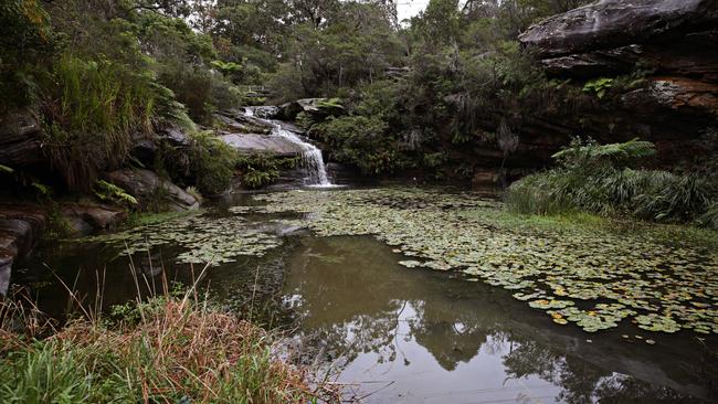
THE CASCADES: DAVIDSON
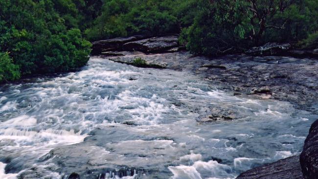
Within Garigal National Park, and a reasonable walking distance from the roadway, is an ancient series a series of beautiful little waterfalls, rock platforms and rockpools at the junction of Middle Harbour and French’s creeks.
The National Parks and Wildlife Service say it’s a “lovely spot to pause and enjoy a picnic” while walking The Cascades Trail.
There is even the remains of a platform for a diving board in the largest pool.
Walkers can make their way to The Cascades from Davison, where the trail starts in Stone Pde, or from St Ives, on the North Shore, from the corner of Acron Rd and Douglas St.
HANGING SWAMP: NORTH HEAD
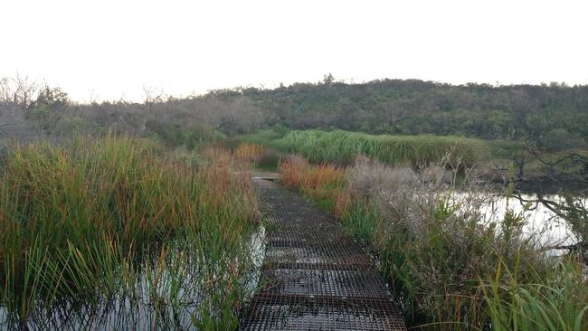
Within North Head Sanctuary on Sydney’s North Head, there is a network of “hanging swamp” wetlands sitting on top of a sandstone base.
The sanctuary is on Sydney Harbour Federation Trust land used by the Australian Defence Force prior to and during World War II, and the School of Artillery up until 1998, before it was opened to the public in 2007.
The trust has created a raised steel grid walkway over part of a swamp, sitting within the landscape made up mostly of Eastern Suburbs Banksia Scrub, not far from the Ave of Honour memorial for those who served Australia in war.
There is a myriad of native plants to see as you walk above the dark waters.
WARRIEWOOD WETLANDS/IRRAWONG WATERFALL
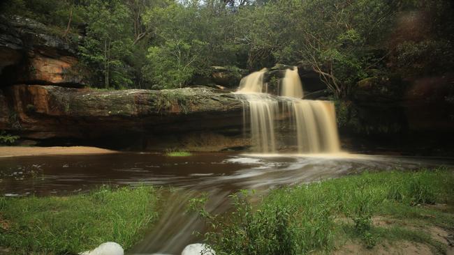
Tucked away just to the northwest of the popular Warriewood Square shopping mall, this 26ha expanse of “sand plain wetland’’ is crisscrossed by 2.4km of raised boardwalks.
Visitors can look out for a variety of native animals such as wallabies and water dragons as well as more than 80 species of birds including powerful owls.
Dogs and bikes aren’t allowed on the boardwalks, but families can use an enclosed playground and BBQs.
A short walk away is Irrawong Reserve and its beautiful waterfall, accessible from Garden St or the end of Irrawong Rd.
STONY RANGE: DEE WHY
Northern Beaches Council describes Stony Range Regional Botanic Garden, on the southern edge the Dee Why CBD, as an “oasis of Australian native plants … in the heart of the northern beaches”.
Just off busy Pittwater Rd, near the intersection with Warringah Rd, the 3.3ha reserve on the site of a disused stone quarry, with its towering trees and shady glades — including a “rainforest gully” — is renowned for its spring floral displays, walks and picnic areas. It even hosts weddings.
The garden is open every day of the year, including public holidays, from 8am to dusk.
THE NATURAL BRIDGE: FORESTVILLE
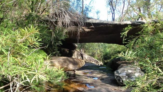
A favourite stop for bushwalkers is the “Natural Bridge” — a sandstone arch that spans a creek in Garigal National Park. You can find it along the The Natural Bridge Track, stretching from Forestville to Davidson.
Experts say the arch has formed by water flowing down the creek, towards Bantry Bay, over thousands of years.
The trail starts near 78 Cook St, Forestville, with the Cook Street Trail linking to the Currie Road Trail, which links with the Natural Bridge Trail that heads towards Davidson Park.
THE TUNNEL OF LOVE: QUEENSCLIFF
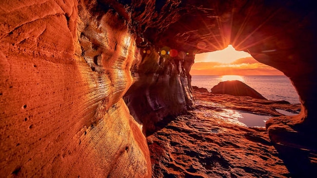
Known by locals as the “tunnel of love” or the “Manly wormhole’, this tunnel carved through the rock beneath the headland between Queenscliff and Freshwater beaches by anglers has fascinated people since it was drilled out in 1908.
The fishers used the 40m tunnel as a shortcut to move between the two beaches.
Now, for those in the know, it's a great place to catch a sunrise with someone special.
Look for the entrance just beyond the Queenscliff rock pool


‘Bit disorganised’: Reality TV star’s excuse for driving without licence
An Australian reality TV star blamed being “a bit disorganised” after returning from shooting a hit show overseas for getting caught driving without a valid licence. See what happened in court.
1st Colts rugby state of play: winners, losers, stars, surprises
After seven rounds there’s one certainty in Sydney Rugby Union 1st Colts - it’s still anyone’s game. The winners, losers, stars, surprises and best storylines so far this season.