
Nearmap aerial imagery reveals changes in southwest Sydney with Western Sydney International Airport progress
Southwestern Sydney has gone from paddocks to estates, and it’s not finished growing with the brand new airport rapidly taking shape. See the change with our interactive tool.
Macarthur
Don't miss out on the headlines from Macarthur. Followed categories will be added to My News.
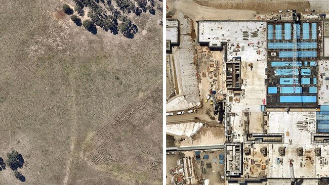
Southwest Sydney has transformed from paddocks and semirural housing to booming estates as the city’s second international airport starts to take shape.
Once complete, the Western Sydney International Airport at Badgerys Creek will establish the city’s west as a gateway to the world.
Aerial imagery company Nearmap has revealed an exclusive look at the construction of the airport from aerial shots, giving southwest Sydney residents a bird’s eye view of progress on the $11bn project.
The final construction package that will create a seamless passenger entry and exit point to Sydney’s new airport is now underway.
The ‘landside’ precinct that integrates car, bus and rail transport to and from the airport will be the welcome mat to Western Sydney International (Nancy-Bird Walton) Airport.
Western Sydney Airport CEO Simon Hickey said commencement of landside works was on schedule to ensure the best passenger experience from day one.
“This construction package connects Australia’s best airport terminal to a major new motorway and Sydney’s rail network, delivering fast, reliable journeys from start to finish,” Mr Hickey said.
“Flying in and out of Western Sydney International Airport will be a breeze from the moment our customers leave the new M12 motorway or one of the airport’s two Sydney Metro stations to the time they make their return journey.”
Western Sydney International Airport is on track to open to international, domestic and air cargo services in late 2026.
The aerial imagery is from location intelligence company Nearmap.
The company provides government organisations, architectural, construction and engineering firms, and other companies, with easy, instant access to high resolution aerial imagery, city-scale 3D content, artificial intelligence data sets, and geospatial tools to assist with urban planning, monitoring and development projects in Australia, New Zealand, and North America.
It’s not just the airport site that has changed dramatically. Surrounding suburbs have also undergone a transformation as developers snap up land to build major projects and housing estates.
With all three major building projects at the site now underway, Western Sydney International Airport is ramping up to its peak phase of construction.
Areas such as Denham Court, Wilton, Austral and Oran Park are almost unrecognisable from three years ago.
“The last of the dump trucks which moved 26 million cubic metres of earth to level the site has left, the terminal is rapidly taking shape, and now we are employing hundreds of people to put the final pieces in place,” Mr Hickey said.
“Around 500 new jobs are being created in addition to the more than 3000 people already working to build an exciting new airport for all of Sydney which will create a new era of jobs, business opportunities and investment for the people who call Western Sydney home.”
The construction of landside works will include more than 4000 carparking spaces for passengers and people working at the airport, with dozens of charge outlets available for electric vehicles.

Join the conversation

Hair today, stars tomorrow! City v Country passion, power, top shots
There were big hits and some hair-raising action – literally – at the 2025 City v Country junior rugby tournament. Check out some of the top shots.
Read more

Silence of the Rams: Unbeaten Macarthur RL run ends after 679 days
After nearly two years, the Camden Rams’ unbeaten run in Macarthur RL has finally come to an end on the road to Mittagong. All the fallout from a chaotic weekend, R14 wrap
Read more