
Central Coast flooding: Residents face nervous wait
Central Coast residents are urged to remain on high alert today with more wild weather including strong winds on the way.
Central Coast
Don't miss out on the headlines from Central Coast. Followed categories will be added to My News.
Central Coast residents are being urged to remain alert and prepare with more wild weather on the way.
The Bureau of Meteorology has issued a severe weather warning for the Central Coast for Tuesday with predictions of around 80mm of rainfall and strong winds with peak gusts in excess of 90km/h.
An evacuation reception centre has been set up by Disaster Welfare Services, Resilience NSW to assist community members affected by flooding.
The centre will be located at Diggers @ The Entrance (315 The Entrance Road) and will operate 24/7.
It comes as the coast was declared a state of natural disaster today.
3.30pm: Anxious wait for lakeside residents
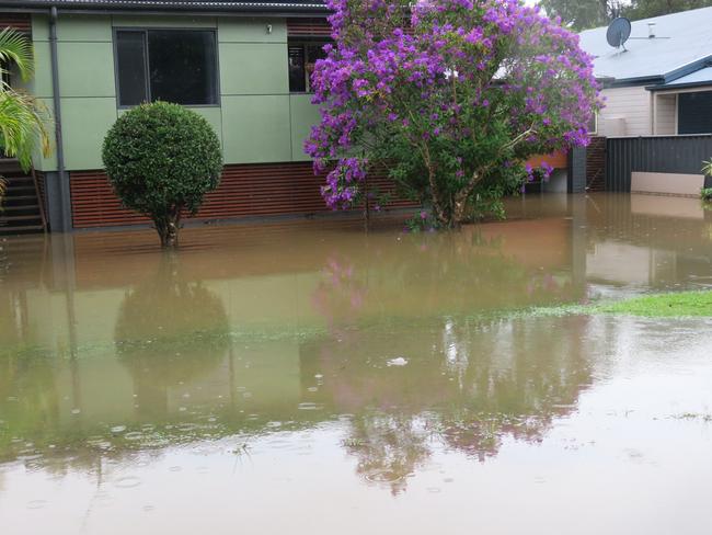
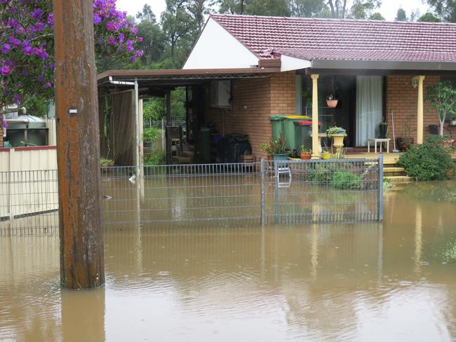
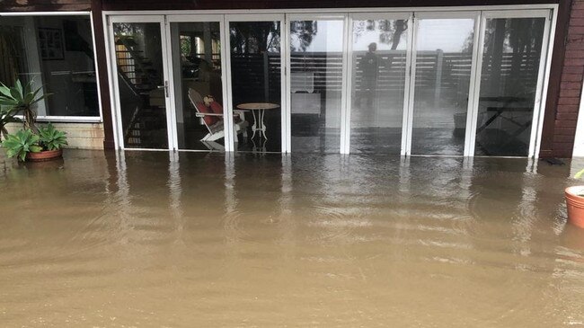
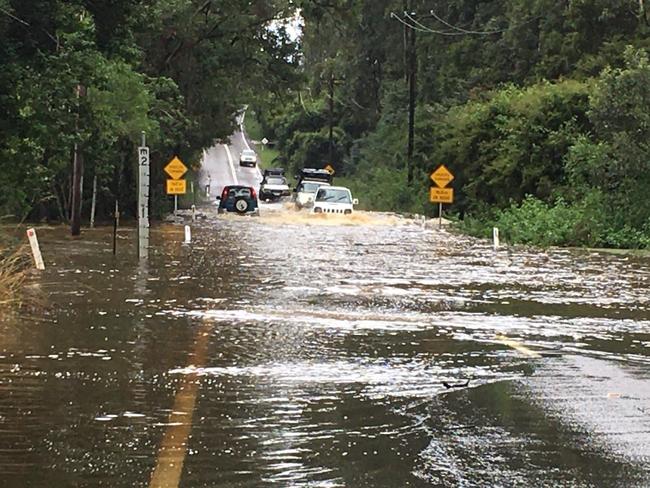
Residents flooded for the second time in just over a year face a nervous wait ahead of high tides at 4.3pm today and 4.34am tomorrow with flood waters not expected to subside for the next 36 hours.
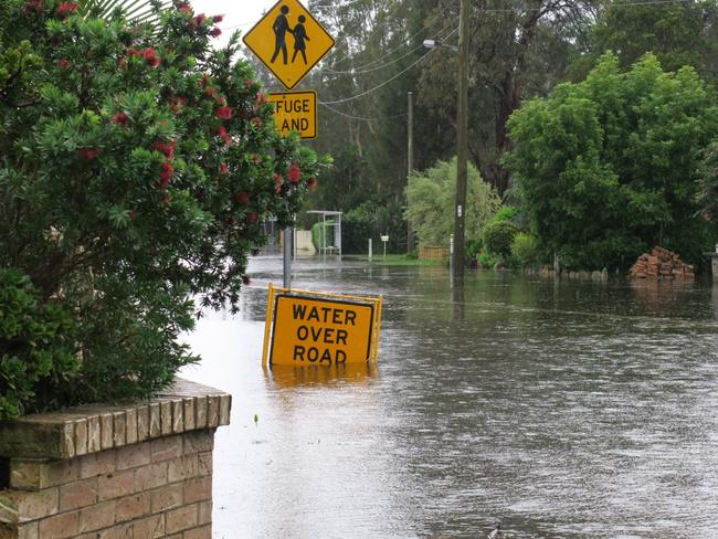
It comes as side streets around Lakedge Ave at Berkeley Vale and Geoffrey Rd at Chittaway Point have become makeshift staging areas for affected residents to park their cars and caravans.
One Lakedge Ave resident told the Express Advocate it was not quite as bad as February last year but it was “sad” having to go through it again within a year
“The only saving grace for me is because the insurance process took so long my place was booked in to get fixed next month,” she said.
“But a lot of people have already had their work done. It’s sad.”
After a wild weekend residents now face a frustrating few days as they try to go back to work and send children to school.
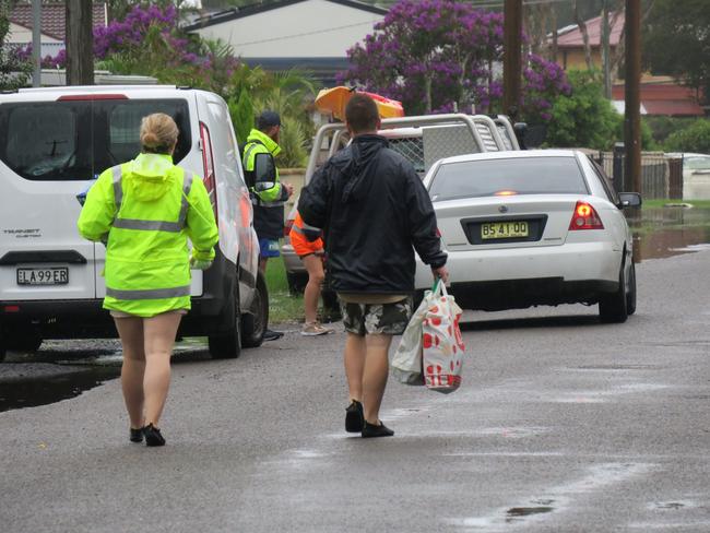
Many are forced to park their cars up the street and wade home through the flood water carrying bags of shopping.
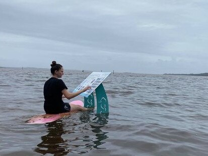
Meanwhile some people have taken to the flooded roads on paddle boards and other craft including Camry Chisholm who was pictured by her sister on a surfboard inspecting a submerged Tuggerah Lakes information sign.
A Central Coast Council said based on previous floods the water would likely remain at its current level for up to 36 hours and not subside to below minor flood level of 0.9m to at least until Wednesday.
A rapid impact assessment is currently being undertaken by the SES, with welfare checks being conducted at impacted properties.
2.30pm: Olympians fear what the future holds
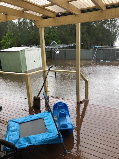
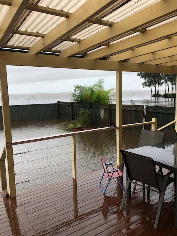
Australian Olympic medal winning skipper Darren Bundock is fearful wild winds forecast for the Central Coast on Tuesday’s will produce waves of water that will flood into his low-lying home on Tuggerah Lake and cause further damage.
Multiple world sailing champion Bundock, who won silver at the Sydney Olympics and bronze at the Beijing Games in 2008, lives overlooking the lake with son Kyle and partner Carolijn Brouwer, a world sailing champion, Olympian and winner of the Volvo round the world race.
Bundock and Brouwer, who went for a “kayak on the bike path’’ on Monday, have relocated many of their downstairs belongings upstairs, elevating furniture on milk crates and packing boats on top of each other to prevent them floating away.
“We are very lucky compared to others,” said Bundock, who is coaching Australia’s top sailing gold medal hopes Jason Waterhouse and Lisa Darmanin ahead of the Tokyo Olympics.

9.30AM: CENTRAL COAST DECLARED A STATE OF NATURAL DISASTER
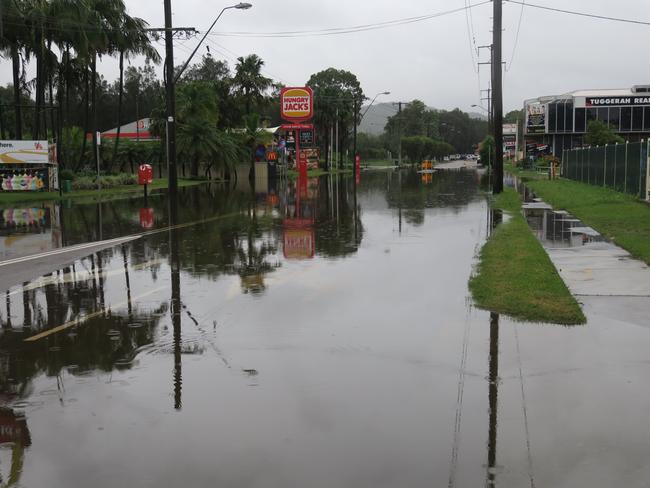
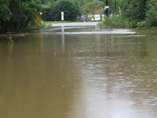
More than 340mm of rain has fallen over the past four days with localised flooding affecting low-lying areas around Tuggerah Lakes as well as areas in and around Lisarow, Ourimbah, Palmdale, Kangy Angy and Narara.
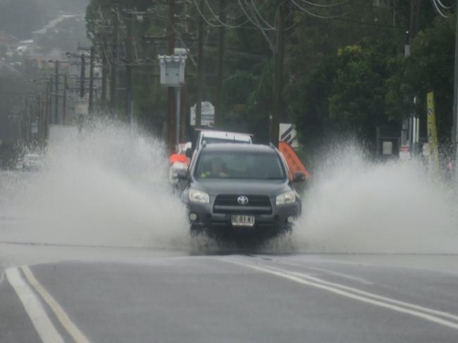
School closures are in place as well as almost 80 road closures, while the State Emergency Services (SES) has responded to more than 765 requests for assistance since the beginning of the storms.
Central Coast Council has advised The Entrance Channel remains open, with an estimated width of 120m, however crews are on standby if the situation changes.
“As at 5.45am this morning, flood levels at Tuggerah Lakes peaked at 1.52 metres and are currently at 1.48 metres and steady,” the council advised.
“We expect that levels may rise a little over the course of the day. This is higher than the April 2015 event when levels peaked at 1.45 metres, but less than the February 2020 event which reached 1.67 metres and when many roads and properties were flooded.
“Based on previous events it will likely stay at this level for up to 36 hours and likely not subside to below minor flood level (0.9m) at least until Wednesday.”
It comes as the coast is declared a state of natural disaster. Central Coast Parliamentary Secretary Adam Crouch said the declaration means that funding and support will flow more quickly to those who need it.
“This means assistance is available to people whose homes or essential households items have been destroyed or damaged, and for business owners who are adversely impacted,” he said.
A dam evacuation warning remains in place for those downstream of Upper and Lower Mooney Dams with heavy rainfall expected to continue into the week.
Spencer residents have also been isolated by floodwaters, with SES crews checking on those affected, while Newcastle Airport has been closed.
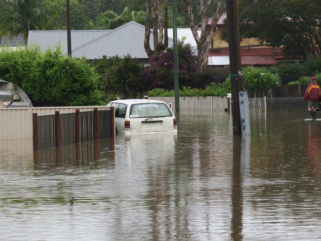
The Central Coast Volunteer Rescue Association, with assistance from Wyong SES have rescued at least eight motorists from flooded cars with people still not heeding the warnings.
Yesterday two passing police came to the rescue of an 80-year-old woman who got trapped in her Hyundai Getz on River Rd, at Wyong, before her car got swept into the river.
About 3:40pm on Sunday the woman drove into the flooded road before her green Hyundai was pushed sideways by the fast flowing water.
As this was occurring two police officers have arrived on the scene for an unrelated matter and observed that the driver was still in the Hyundai.
One of the officers, an acting inspector, entered the water on foot and was able to remove the 80-year-old woman from the Hyundai. The Hyundai was then pushed by the water into the nearby Wyong River.
No injuries were sustained to either the motorist or the officer.
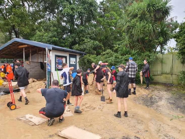
The Central Coast Bombers AFL club has pitched in and helped the Wyong SES bag about 50 tonnes of sandbags over the past three days.
Many students woke to messages their schools were shut including St Peters Catholic College at Tuggerah, which was closed because of flooding along Gavenlock Rd as well as St Cecilia’s Catholic Primary School at Wyong. Other closures include Lisarow Public School, Lisarow High School, Narara Valley High School, Wyong Creek Public School, Glenvale School (North Entrance campus), Jilliby Public School and MacDonald Valley Public School along with the Ourimbah University campus.
Busways has also advised that the flooding situation was affecting bus routes across the region.
“Due to flooding, parents, students and commuters are advised that many bus services are not running today 22 March, including school bus services,” the company advised.
“Stay up to date on travel conditions and unplanned bus service disruptions by checking real-time apps and Twitter @BusesInfo Twitter @NSWSES.”
For the latest information on public transport call 131 500.
WAMBERAL EROSION UPDATE
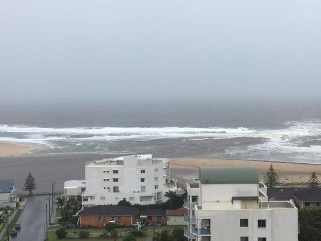
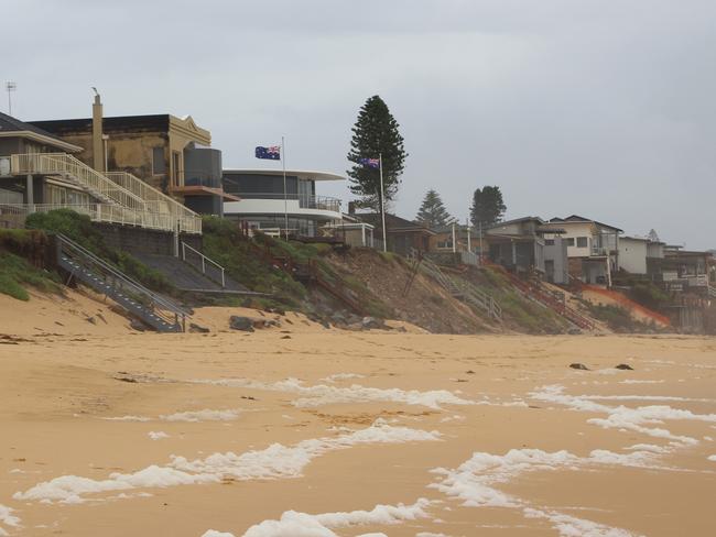
The ongoing rain has also brought rough seas as council closely monitors the Wamberal Beach erosion site.
In July 2020, homes along Ocean View Dr partly crumbled into the ocean following damaging winds and surf conditions.
Subsequent weather events have brought many nervous days and nights for residents.
A spokeswoman from Central Coast Council told the Express that “the emergency toe dune protection structure installed at Wamberal in August and September of last year remains intact and has not been impacted by the recent extreme weather”.
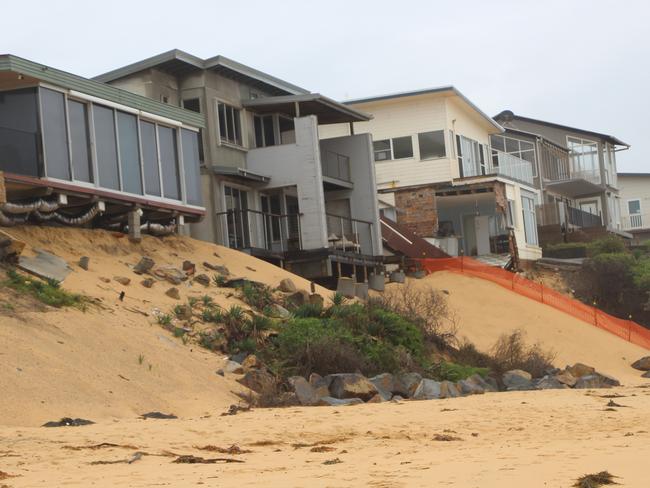
Emergency works included laying around 520 tonnes of rock in bags at the toe of the emergency erosion site with another 1100 tonnes of large individual rocks placed at the base of the sand dune.
“Council staff will work in accordance with the identified recommendations of the Coastal Erosion Emergency Action Subplan for Wamberal-Terrigal Beach which includes erecting barriers and signage as required, seeking coastal and geotechnical engineering advice as required and supporting the State Emergency Service,” the spokeswoman said.
“If properties are damaged, they should contact the SES for support. Council staff are continuing to monitor the impacts of the weather event across the Central Coast, including at Wamberal Beach, and will respond to situations as they arise.”
ROAD CLOSURES
– Ace Crescent, Tuggerah
– Aloha Dr, Chittaway Bay
– Anzac Road, Tuggerah
– Braithwaite Street, Tacoma
– Burns Road, Ourimbah
– Carlton Road, Holgate
– Carrington Street, Narara’
– Dean Street and Narara Valley Drive, Narara
– Durren Road, Jilliby (intersection of Smiths Road to Jilliby Road)
– Fairway Drive, Terrigal
– George Downs Drive, Kulnura (northbound lane closed between Springs Rd and Williams Rd – proceed with caution)
– Gavenlock Road, Mardi
– Hanalei Ave, Chittaway Bay
– Hanlan Street, Narara
– Hillcrest Ave, Tacoma
– Ironbark Bridge, Lower Mangrove – this bridge is currently inaccessible
– Jefferies Road, Chittaway Point
– Jilliby Road, Jilliby (from Hue Hue to Watagan Forest Drive)
– Johnson Road, Tuggerah
– Kallaroo Road to Emu Road, San Remo
– Kennedy Road, Wyong
– Kooindah Waters Golf Course to Jensen Road, Wyong
– Lakedge Ave, Chittaway Bay and Berkeley Vale, including all side streets
– Lake Street, Long Jetty
– Lauffs Lane, Yarramalong
– Leichhardt Road, Wyong
– Linga Longa, Yarramalong
– Lucinda Ave, Killarney Vale including all side streets
– Mandalong Road, Durren Durren (from Jilliby Road Durren Durren)
– Mann’s Road, West Gosford
– Milina Road, Holgate
– MacDonald’s Road and Pacific Highway, Lisarow
– Mcdonagh Road, Wyong
– McPherson Rd, Mardi (closed at both the Mardi and South Tacoma ends)
– Newcastle Street, Springfield
– Old Maitland Road, Alison (at Woodbury Park Inn)
– Oyster Shell Road, Spencer
– Pandala Road, Narara
– Panonia Road, Wyong
– Panorama Road, Wyong
– Reeves Street, Narara
– River Road and Pacific Highway, Wyong
– Shirley Street, Ourimbah
– Showground Road, Gosford
– The Ridgeway and Pacific Highway, Lisarow
– Teralba Street, Lisarow
– Tuggerah Parade, The Entrance and all side streets alongside this road
– Wallarah Creek Bridge near Pacific Highway, Charmhaven
– Willoughby Road, Wamberal
– Willow Road, Springfield
– Wolseley Ave, Tacoma
– Woodbury Park Drive, Mardi
– Yarramalong Road, Alison (at the intersection of Hue Hue Road)
– Yarramalong Road, Wyong Creek (Lauffs Lane)
– Yarramalong Road, Yarramalong (approximately 1 kilometre before Bumble Hill road)
More Coverage
Read related topics:NSW floods

Couple’s power move gets them 18 homes, $11m
An Aussie sparkie and nurse who had been losing $40,000 a year have revealed the surprise change that turned it all around.
Read more

‘Like Brian To’o’: U16 players to watch at City v Country rugby
Young guns in the U16s City v Country battle will be playing for more than pride and victory on Sunday. Some of the rising stars to watch as players from both teams vie for special rep honours
Read more