
Central Coast weather: Council warning of rising flood levels at Tuggerah Lakes
UPDATE: Residents remain on high alert as two local dams are spilling, while floodwaters have isolated Spencer. It comes as school closures are announced.

Central Coast
Don't miss out on the headlines from Central Coast. Followed categories will be added to My News.
Spencer residents have been isolated by floodwaters while the upper and lower Mooney Dams are spilling.
Central Coast Council has announced that the SES and Disaster Welfare have made contact with affected residents of Spencer, while residents downstream of the Upper and Lower Mooney dams are on high alert.
It comes as some Central Coast schools announce closures for tomorrow due to the ongoing severe weather warnings and flooding. These include: Lisarow Public School, Lisarow High School, Narara Valley High School, Wyong Creek Public School, Jiliby Public School and MacDonald Valley Public School.
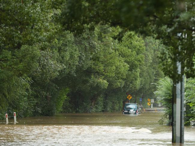
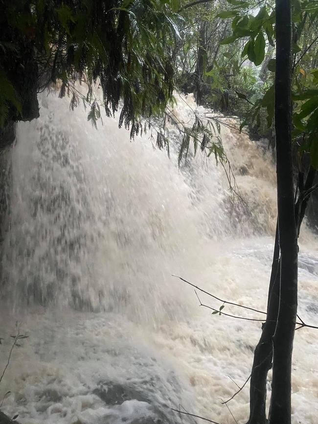
The coast has had more than 340mm of rainfall over the past four days with rain expected to continue over the coming days.
“As at 2.30pm today, flood levels Tuggerah Lakes are at 1.39 metres. The lake levels will not peak until approximately 24 hours after the rainfall event and it is likely to peak at 1.50m on Monday morning,” council has advised.
“Based on previous events it will likely stay at this level for up to 36 hours and likely not subside to below minor flood level (0.9m) until Wednesday or Thursday. The expected peak is higher than the April 2015 event when levels peaked at 1.45 metres, but less than the February 2020 event which reached 1.67 metres and when many roads and properties were flooded.
2.30PM UPDATE
Flood levels across Tuggerah Lakes continue to climb with an expected peak of 1.5m on Sunday afternoon.
With 250-300mm of rain already fallen and torrential rain expected to pick up again, Central Coast Council has provided an update on flood levels.
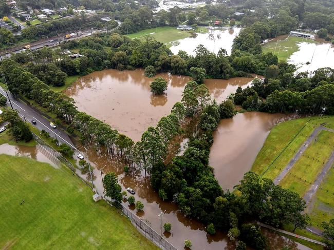
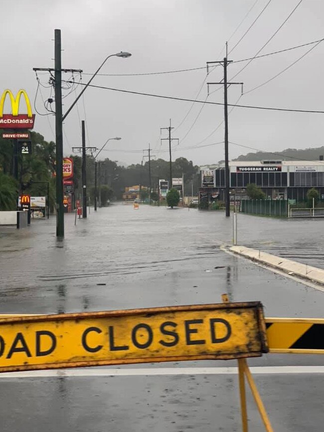
Localised flooding is impacting low-lying areas around Tuggerah Lakes while areas such as Narara, Niagara Park, Palmdale, Lisarow, Kangy Angy and Ourimbah are also severely affected.
“As at 9am today, flood levels Tuggerah Lakes are at 1.32 metres and may reach around 1.50 metres by Sunday afternoon,” acting CEO Rik Hart said.
“This is higher than the April 2015 flooding event when levels peaked at 1.45 metres, but less than the February 2020 event which reached 1.67 metres when many roads and properties were flooded.
“The flood peak may last 12 to 24 hours and the lake level may remain above the minor flood level (0.90 metres) until late Monday. Senior Council staff have been on the ground today, with crews responding to impacts.”
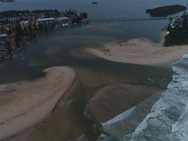
Mr Hart said The Entrance Channel remained open and flowing with an estimated width of 80 metres.
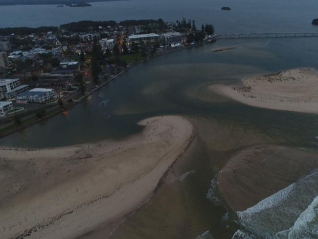
“This is more than 50 per cent wider than it was at the commencement of the February 2020 flood event,” he said.
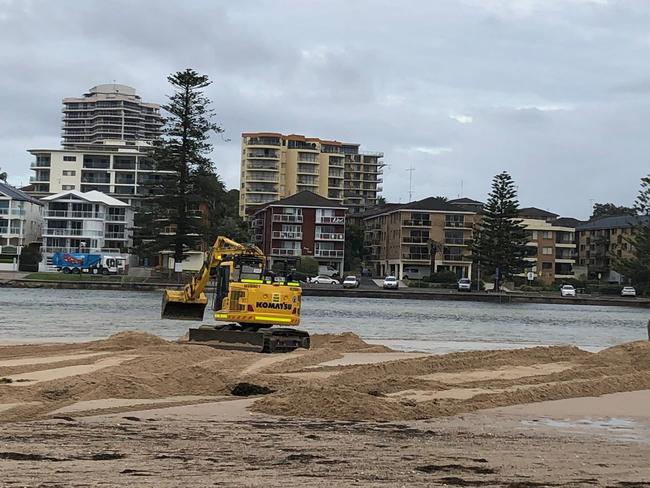
“The minor channel maintenance work removed a small amount of sand on the north side of The Entrance Channel to allow for a more direct flow path of predicted floodwaters and heavy machinery is on standby, should any further unforeseen works be required.”
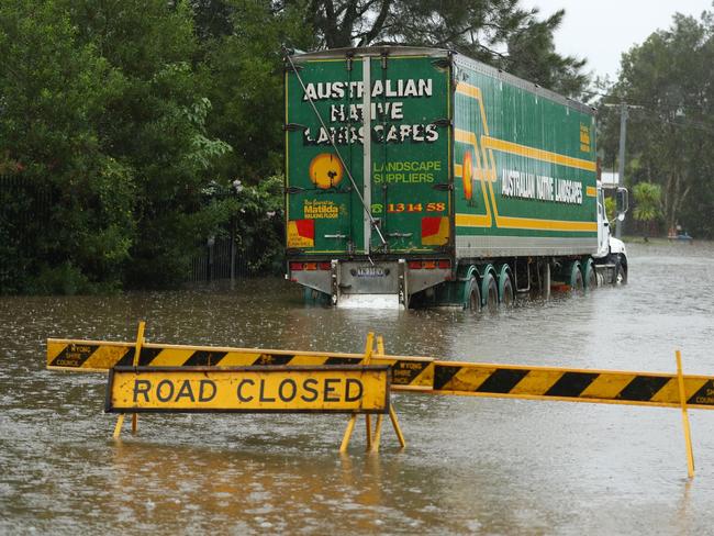
SES have crews have received to 673 requests for assistance, there have been 78 road closures and power outages are happening in areas such as Yarramalong, Mangrove Mountain, Glenworth Valley and Mount White.
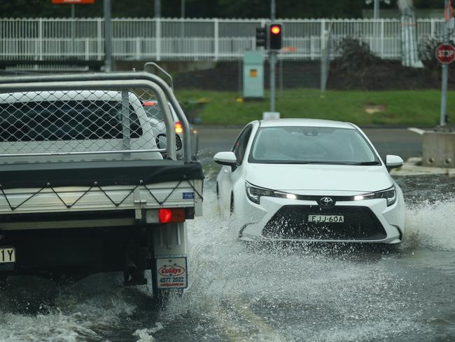
“I’d like to take this opportunity reinforce that residents should slow down and drive to the conditions and avoid driving or walking in or near floodwaters – remember, if it’s flooded, forget it. There is also the potential for fallen trees due to wind gusts over the next 24 hours, so please be careful,” Mr Hart said.
10AM UPDATE
As the torrential rain continues across the Central Coast, residents are being warned that the storm event could be more serious than the February 2020 flooding.
Central Coast Council has advised residents to be on high alert with the severe weather warning still in place for the region and minor flooding already impacting Tuggerah Lakes.
“Current best projections from Bureau of Meteorology indicate that there will be likely localised flooding and residents should prepare accordingly,” a media statement from the council read.
“The Bureau of Meteorology has advised that Tuggerah Lakes may reach around 1.50 metres by Sunday afternoon. This level is higher than the April 2015 event when levels peaked at 1.45 metres, but less than the February 2020 event which reached 1.67 metres and when many roads and properties were flooded.”
The February 2020 floods saw hundreds of homes near Tuggerah Lakes inundated with water, as wild weather swept across the coast and many properties are still recovering from the event.
Flood waters are expected to continue to rise over the coming days and residents are urged to be prepared.
“Based on current predictions, the flood peak may last 12 to 24 hours. Tuggerah Lakes may remain above the minor flood level (0.90m) until late Monday,” the council states.
Administrator Dick Persson said The Entrance Channel remained open and crews are on the ground ready to respond.
“I understand community members who reside around Tuggerah Lake will be significantly impacted, with flood levels currently predicted to reach those experienced in February 2020.
We are doing everything we can to make a difference,” he said on Saturday.
“The acting CEO Rik Hart is in charge and senior executives are onsite. There is no action possible that will increase the outflow at this stage. Machinery is on standby should sand build up occur or the outlet is restricted, it will be cleared.”
Mooney Mooney Dam is “spilling” and levels are being monitored by SES and council staff, while the minor flood warning for Wyong River is no longer in place.
Council has urged people to avoid unnecessary travel along with swimming in the coast’s waterways.
Meanwhile the Central Coast Rescue Squad has been in action responding to flood rescues and have put out a call urging people not to attempt to drive through deep water.
“In the early hours of this morning crews from multiple services have spent hours attending vehicles that have entered flood waters which then required assistance,” the group posted to social media.
Gosford and Wyong SES crews have set up sand bag pick up locations. Wyong SES will have bags available at 10.30pm on Sunday at the San Remo Boat Ramp car park, Sunshine Reserve, Geoffrey Rd, Chittaway Point and Wyong SES in Levitt Street, Wyong.
Bags can also be pick up from Gosford SES at 1 Pateman Rd, Erina.
ROAD CLOSURES – SUNDAY MARCH 21
– Ace Crescent, Tuggerah
– Aloha Dr, Chittaway Bay
– Anzac Road, Tuggerah
– Burns Road, Ourimbah
– Carlton Road, Holgate
– Carrington Street, Narara
– Durren Road, Jilliby (intersection of Smiths Road to Jilliby Road)
– Fairway Drive, Terrigal
– Gavenlock Road, Mardi
– Hanalei Ave, Chittaway Bay
– Hanlan Street, Narara
– Jefferies Road, Chittaway Point
– Jilliby Road, Jilliby (from Hue Hue to Watagan Forest Drive)
– Johnson Road, Tuggerah
– Lakedge Ave, Chittaway Bay
– Lauffs Lane, Yarramalong
– Linga Longa, Yarramalong
– Lucinda Ave, Killarney Vale
– Mandalong Road, Durren Durren (from Jilliby Road Durren Durren)
– Mann’s Road, West Gosford
– Milina Road, Holgate
– McPherson Rd, Mardi (closed at both the Mardi and South Tacoma ends)
– Old Maitland Road, Alison (at Woodbury Park Inn)
– Pandala Road, Narara
– Panonia Road, Wyong
– Reeves Street, Narara
– Shirley Street, Ourimbah
– Showground Road, Gosford
– Teralba Street, Lisarow
– Willoughby Road, Wamberal
– Willow Road, Springfield
– Woodbury Park Drive, Mardi
– Yarramalong Road, Alison (at the intersection of Hue Hue Road)
– Yarramalong Road, Wyong Creek (Lauffs Lane)
– Yarramalong Road, Yarramalong (approximately 1 kilometre before Bumble Hill road)
More Coverage

Join the conversation

‘Like the Honey Badger’: U16 players to watch at City v Country rugby
Young guns in the U16s City v Country battle will be playing for more than pride and victory on Sunday. Rising stars - including ones likened to the Honey Badger and Brian To’o - to watch
Read more

Serial drink driver avoids jail after 6th offence behind the wheel
An Ettalong roofer with a shocking record of drink-driving and licence breaches has been sentenced after being caught behind the wheel while suspended and over the limit for the sixth time.
Read more