Christmas bomb cyclone threatens US East Coast
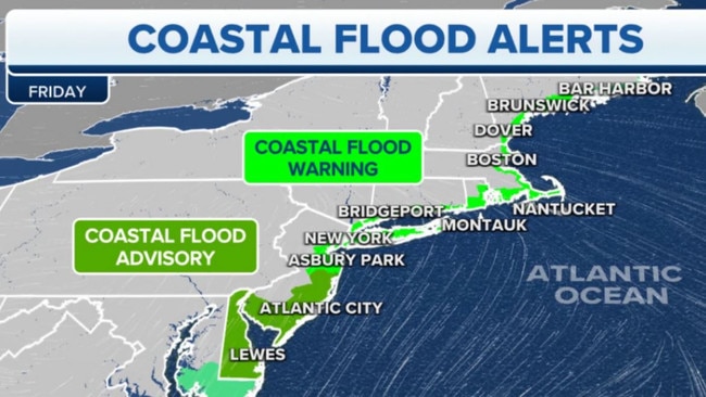
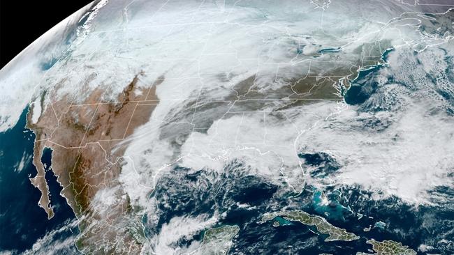
A powerful “bomb cyclone” storm pummeling the Midwest is expected to cause heavy rain and flooding in the New York area this weekend.

World
Don't miss out on the headlines from World. Followed categories will be added to My News.
The powerful “bomb cyclone” storm now pummeling the Midwest is expected to strike parts of the Northeast on Friday local time – causing heavy rain and flooding in the New York area this holiday weekend, meteorologists warned.
Parts of New Jersey, Maine and Long Island are expected to be swamped by 1 to 3 feet (30cm to 91cm) of flooding followed by freezing during peak holiday travel times, said Fox Weather meteorologist Marissa Lautenbacher, the NY Post reported.
“This storm is very, very strong and has a deep cold air blast from the Arctic,” said Lautenbacher. “It’s going to have a big impact.”
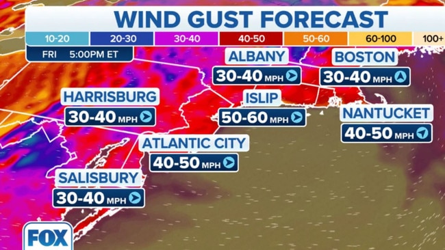
Rapidly strengthening Arctic winds are forecast to blow up to 60m/h (96km/h) from the Great Lakes region to Buffalo, New York, and in parts of New England beginning Friday, potentially knocking out power.
In New York City, Rockaway Beach residents – many of whom were devastated by floods during Superstorm Sandy a decade ago – were bracing for a possible disaster on Thursday.
“We already have significant coastal erosion from storms this year and the timing of the tide and moon cycle make for a perfect storm,” said a city worker who lives in the Rockaways. “It’s not a question of if we lose power – but when, is my feeling. New York City and (the) south shore of Long Island need to hope for the best but prepare for the worst.”

Some folks in the neighbourhood were frantically prepping on Thursday.
“Stop and Shop in Rockaway is out of control. I just hear people in Rockaway starting to panic. Every register is open. And, believe me, it is not just for preparing Christmas dinner,” the worker said.
The New York area will be hit by heavy rain followed by a temperature drop of up to 30 degrees fahrenheit (-1C), which could cause a “flash freeze” on roads – leading to treacherous driving conditions Friday evening, Lautenbacher said.
“On the I-95 corridor, all that ponding will freeze and become ice,” she said. “Drivers are going to have to watch for slick spots.”
Con Edison said on Thursday it was gearing up for widespread power outages in New York City and Westchester County by dispatching more than 700 workers to fix fallen lines.
“The wind could bring down power lines, causing customers to lose service and creating a safety hazard,” the firm said in a press release. “In addition, road salt will mix with melting ice and could damage underground electrical wiring and lead to outages.”
High winds in the Boston and northern New England areas are also expected to cause power outages, potentially forcing some residents to go without heat in below-freezing conditions.

“With it being so cold, people need a contingency plan,” Lautenbacher said.
In New York City, temperatures are expected to plunge from a high of 53 degrees fahrenheit (11 celsius) Friday to 22 fahrenheit (-5 celsius) on Saturday – but it will feel like minus 4 fahrenheit (-15 celsius) with high gusts of chilly wind.
“Make sure to bundle up and avoid exposed skin,” Lautenbacher warned. “If you start to feel a tingling sensation, go inside and stay warm.”
Overall, the worst of the storm is expected to pass by late Saturday, she said.

A bomb cyclone is defined as a rapidly strengthening storm that drops 24 millibars in pressure in less than 24 hours.
In 2012, Superstorm Sandy flooded the Rockaways in New York City with 10 feet (3m) of water.
By contrast, this weekend’s forecast bomb cyclone is expected to flood the Rockaways with up to 3 feet (90cm) of water.
This article originally appeared on the NY Post and was reproduced with permission
Originally published as Christmas bomb cyclone threatens US East Coast


