
Mount Dick to Humpybong Creek: Queensland’s rudest named places exposed
From Booby Island to Mount Dick, Queensland is home to some questionable named places that bring a cheeky smile to your face. Take a tour of the most interesting from Bum Bum Creek to Bald Knob.
Regional News
Don't miss out on the headlines from Regional News. Followed categories will be added to My News.
Crude, rude and just downright funny, Queensland is home to some of Australia’s most hilariously named beaches, streets, creeks and suburbs.
From popular tourist spots like Nobby Beach to deserted areas like Big Woody Island, each of these places has a story behind it and some of them are not as humorous as you might imagine.
Take a raunchy road trip through Queensland and check out our list of the state’s rudest and crudest places and how they came to be.
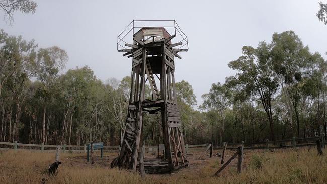
YORKEYS KNOB
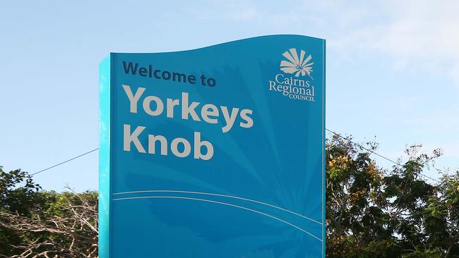
Claimed to be one of Tropical North Queensland’s “best kept secrets”, Yorkeys Knob is a coastal town 10 minutes north of Cairns, home to sugarcane farms, Half Moon Bay Marina and Golf Club, and Yorkeys Knob Beach.
Nicknamed ‘Yorkey’ or even sometimes ‘The Knob’, the beachside town is believed to have gotten its name from George Lawson, a Yorkshire man. According to legend, he set up camp in the coastal suburb in the 1880s which reminded him of his hometown fishing village where a hill was referred to as a “nab”, later translating to “knob”.
Looking out into the Coral Sea, Yorkeys Knob is known for being one of the best kitesurfing destinations in the world, and is a popular for fishing.
BOOBY ISLAND
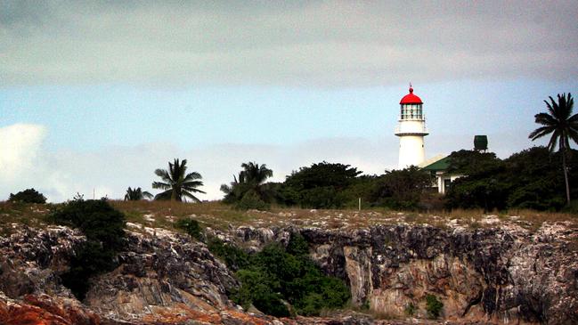
Located at the tip of Cape York Peninsula within the Endeavour Strait of Queensland and the Shire of the Torres Strait, Booby Island is a private island that features its own lighthouse, aptly named Booby Lighthouse.
Only accessible by boat or helicopter with special permissions, Booby Island is known as Ngiangu by its traditional owners but was named Booby Island by James Cook in 1770 as the island was “frequented by birds such as Boobies”.
Featuring a heritage-listed lighthouse constructed in 1890, the lighthouse was one of the last to be constructed along the Queensland coast to help mark the difficult Western entrance through to the Torres Strait after many ships wrecked on Booby Island during voyage throughout the 19th century.
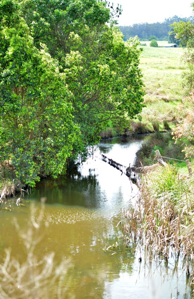
HUMPYBONG CREEK
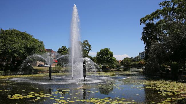
Located just a quick stroll from the Esplanade in Redcliffe, Humpybong Creek is a popular nature reserve in the Moreton Bay Region and features various waterbirds, water fountains and dolphin statues to observe.
Home to various fish, eels, turtles and frogs, the name of Humpybong Creek is believed to have come from the Aboriginal words of ‘ngumpin’ and ‘bong’ translating to ‘deserted shelters’ or ‘dead houses’, referring to abandoned European settlements in Redcliffe after colonists moved to Brisbane in the 1820s.
While Redcliffe itself was close to being called Humpybong, locals can still enjoy Humpybong Creek and its assortment of wildlife via a peaceful pathway that goes along the river.
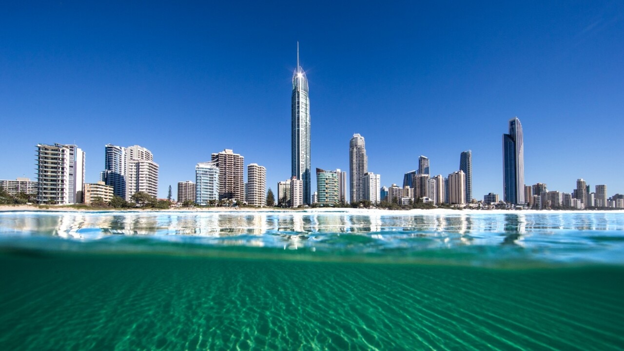
NOBBY BEACH
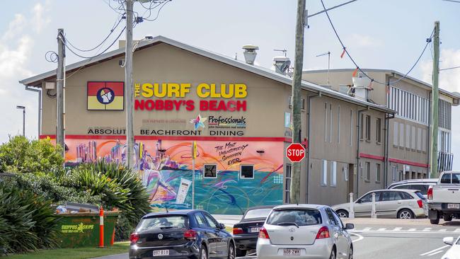
Just south of Surfers Paradise in the heart of the Gold Coast, Nobby Beach is a small beachside destination with a lot to offer, known among locals as a quiet spot, complete with its own surf club, showers, barbecue facilities and sheltered picnic tables.
Located between Mermaid Beach and Miami Beach, Nobby Beach is directly near two headlands known as ‘The Nobbys’, rumoured to have been named after settler and grazier Frederick Fowler’s lead bullock (or male cattle) who roamed around the headlands and was named ‘Nobby’.
While there’s no clear answer of the origins of the beachside suburb’s name, Nobby Beach is home to various trendy bars and restaurants, including Australia’s first 100 per cent plant-based ramen restaurant ‘I Like Ramen’.
WONGLEPONG
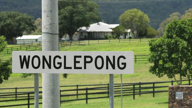
A rural town with a population of just 341 people, Wonglepong is a suburb in the Scenic Rim region, located on the fringe of Mount Tamborine and 45 minutes west from the Gold Coast.
Named after the local railway station which was built in 1927, the name ‘Wonglepong’ is believed to have been derived from the Bundjalung language for a word meaning ‘forgotten sound’.
Originally named Sarah Vale, Wonglepong is home to the heritage listed Wonglepong QCWA Hall, constructed in the 1930s to be used as a hall for the Queensland Country Women’s Association.
The nine-metre by six-metre hall situated on a forty-five hectare farm is constructed from timber and weatherboard and features the QCWA symbol on the gable upon entry.
BURPENGARY
Located 37km north of Brisbane and just south of Morayfield, Burpengary is one of Moreton Bay’s fastest growing residential areas, undergoing an insane population growth from 1991 to 2001, from just 5163 people to 17,395.
Once a small rural village used for timber cutting, the name Burpengary is believed to have been derived for the Aboriginal expression ‘burpengar’, translating to ‘place of green wattle’.
Situated nearby Deception Bay, Caboolture and North Lakes, Burpengary is home to various schools, parks and shopping centres but is perhaps most well loved for the Burpengary Market, a weekly event on Station Rd selling fresh produce, art and products from local businesses.
BALD KNOB
Just over an hour north of Brisbane, Bald Knob is a rural town in the Sunshine Coast near Maleny with a small population of around 280 people.
The town’s unusual name was chosen by a Samuel Burgess in 1895, named after the location’s prominent “lightly forested bald” mountain feature which stood out from the surrounding forest.
MINGELA
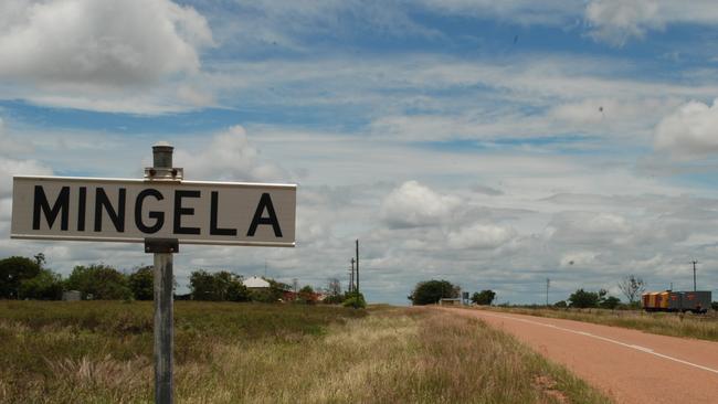
A rural town with a population of around 20 people, Mingela is a small suburb in the Charters Towers region that was reportedly named after the Aboriginal word for a “string of waterholes”.
Originally named Cunningham in 1861 after European settler Edward Cunningham, the town was later renamed to Ravenswood Junction in 1884 after opening a railway junction to service the Ravenswood gold rush in 1869 and the Charters Towers rush of 1872.
Renamed again in 1931, the town was officially called Mingela and is home to Mingela State Forest, a 16km stretch of national park with views of the Hervey Range.
LITTLE UGLY CREEK
Located along Moggil Conservation Park in Anstead, Little Ugly Creek is a watercourse just 27km west of Brisbane, located near a popular swimming hole ‘Ugly Gully’ at Kholo Creek.
Little Ugly Creek and Kholo Creek appeared in headlines during the murder investigation of Allison Baden-Clay in 2012 after her body was discovered in adjoining bushlands with drag marks leading into one of the creeks.
Baden-Clay’s husband, Gerard Baden-Clay was later found guilty of her murder and given a life sentence at Brisbane Supreme Court in 2014.
DICKY BEACH
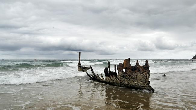
Two kilometres north of Caloundra along the Sunshine Coast you’ll find Dicky Beach, a surfing and swimming haven in the form of an 800-metre long beach near Caloundra head.
Named after the SS Dicky which was wrecked on the beach in 1893 during a cyclone, Dicky Beach became known for its shipwreck which remained on the beach for more than 100 years until its removal in 2014 due to safety concerns.
The wreck itself was once used as a venue for dances until a kerosene lamp overturned and burned out the ship, with the burnt vessel remaining on the beach for 122 years.
Locals and visitors can still learn the history of the SS Dicky in an interactive display featuring the ship’s propeller in a nearby park.
Besides shipwrecks and a name that might make you chuckle, Dicky Beach is home to bike paths, a skatepark and fishing spots as well as various caravan sites and holiday spots including Dicky Beach Family Holiday Park.
WANKAROO FALLS
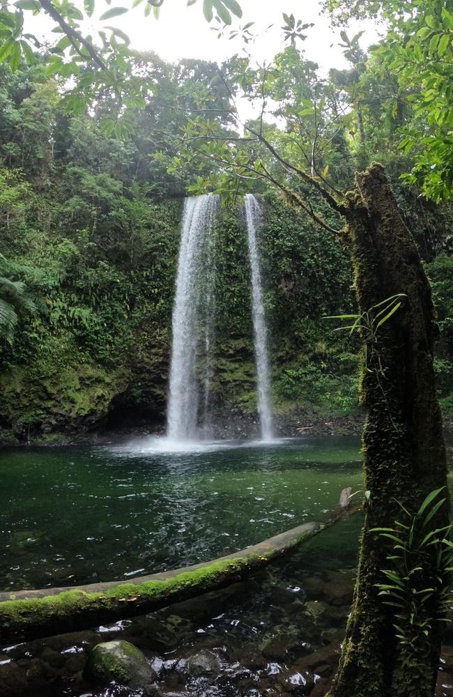
A hidden gem in Wooroonooran National Park in Far North Queensland, Wankaroo Falls is a serene 25-metre single plunge waterfall in Wankaroo Creek that is only accessible by a challenging hike which ranges from three to six hours one-way.
Located in Wooroonooran, an hour south of Cairns, the trail to Wankaroo Falls can be found by going to the Biggs Recreational Reserve, or as it’s nicknamed, the ‘Golden Hole’ at Bartle Frere.
The journey to Wankaroo Falls is around nine to 13 kilometres depending on the path you take, but involves various creek crossings ad an overall wet and muddy hike to reach the picturesque destination with a very amusing name.
MOUNT MEE
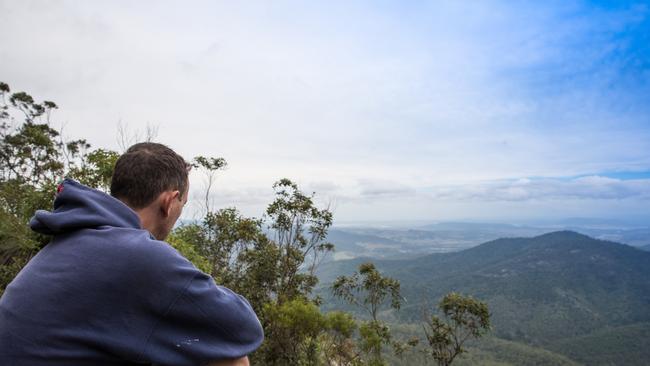
Overlooking the Glasshouse Mountains, Mount Mee is a rural town 90 minutes north west of Brisbane that’s known for its forest reserve, a popular four-wheel driving and biking spot.
Part of the D’Aguilar Range, the Mount Mee Forest Reserve features native and plantation forests, as well as rainforest walks and waterholes, including the popular Rocky Hole, accessible only via dirt roads.
Part of the Moreton Bay Region, Mount Mee is believed come from the Aboriginal words ‘mia mia’, referring to a view or an outlook.
Home to Mount Mee State School and Mount Mee Public Hall, the small town is also home to an antique 1930s sawmill ‘The Gantry’ where visitors can enjoy covered picnic areas and BBQ shelters.
MOUNT DICK
Situated near Lakes Creek and Nerimbera, Mount Dick is a mountain peak near Rockhampton with an elevation of more than 200 metres which can be seen from Sleipner Lookout and Fraser Park Lookout in Mount Archer.
Also historically referred to as Mount Warner and Mount Morgan, Mount Dick is situated just half an hour east of the Rockhampton CBD, located just north of Old Nerimbera School and Rockhampton Pistol Club.
It is unclear where the origins of the name Mount Dick come from.
BUSHY ISLAND
Located 70km east of Mackay within the Great Barrier Reef World Heritage Area you’ll find Bushy Island, an isolated 4.5ha vegetated coral cay.
Only accessible by seaplane, the island has no visitor facilities and is rarely frequented by tourists due to its vulnerable nesting habitat areas, providing a rookery for up to 100 green turtles and a roosting area for 10,000 birds every nesting season.
The only coral cay in the Great Barrier Reef supporting orange-footed scrubfowl population, Bushy Island may not be a major Queensland tourism destination, but provides an important national park for Australian wildlife.
BUM BUM CREEK
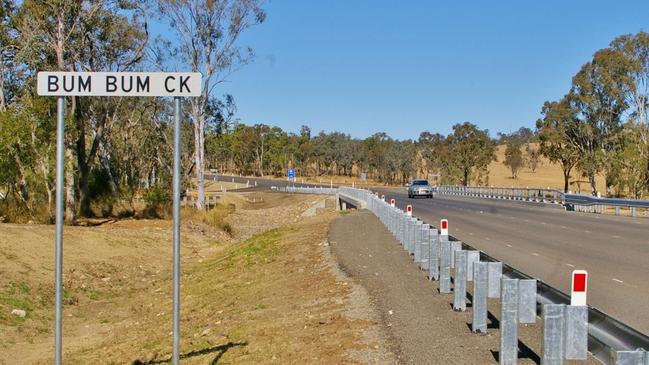
Named by the Queensland Place Names Board in 1965, Bum Bum Creek is located along the New England Highway, two hours northwest of Brisbane near Crows Nest.
A funny spot to locals, a sign stating ‘Bum Bum Creek’ next to the road is often stolen.
JACKASS CREEK
Known locally as ‘Jackass Creek’ for years, the name of this Gympie watercourse was officially recognised by the State Government in 2013 after historians found it was referred to as Jackass Creek in several newspaper articles in 1947 and 1952.
Located below Mount Eagle in southeast Queensland, the origin of the name Jackass Creek is unknown.
BULCOCK BEACH
Pronounced by locals as “bull cock beach”, this coastal town is located in Caloundra on the Sunshine Coast and home to various picnic areas, restaurants, piers and boardwalks.
A popular spot for weddings and family gatherings, Bulcock Beach is opposite the northern end of Bribie Island which can be accessed by a short walk from Bulcock Beach during low tide.
Famous for its fishing, boardwalks and family friendly patrolled beach, Bulcock Beach is a hidden jewel of Caloundra that makes an ideal holiday destination.
WOODY POINT
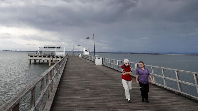
Known as the landing spot of Mathew Flinders in 1799, Woody Point is a quiet seaside town at the southern tip of the Redcliffe Peninsula, just 35km northeast of Brisbane.
Rumoured to have originally been a banana plantation, Woody Point is most well known for its popular fishing spot Woody Point Jetty, a 240m jetty constructed in the early 1880s and later reconstructed in 2008 for $9.6m.
Equipped with picnic facilities, beachside spots and the local Humpybong Yacht Club, Woody Point is also home to The Belvedere Hotel, or ‘The Bel’, an 1890s boarding house which was later converted into a hotel and pub in 1901.
JERKING CREEK BORE
Located near Tangorin and Natrim in the Flinders Shire, Jerking Creek Bore is a body of water located in rural Queensland with little information regarding the origins of its name.
While some sources refer to Jerking Creek Bore as a fishing spot and a drinking water location, people may be turned off drinking the water due to its unfortunate name.
NOBBY
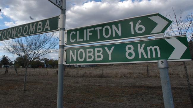
Nobby is a small historic town located halfway between Toowoomba and Warwick which is most well known by its Australian author Steele Rudd who found inspiration for his book series On Our Selection in the rural town in the Darling Downs.
30km south of Toowoomba, Nobby was originally known as McDonald Campin the late 19th Century while a railway was constructed between Toowoomba and Hendon.
The town was officially named Nobby in the 1930s, however the origin of the name is unknown.
Nobby was originally a centre for wheat and dairy farming and is home to iconic attractions including Rudd’s Pub and the Sister Kenny Memorial, chronicling the life of Sister Elizabeth Kenny who made a significant impact developing treatments for polio in the mid twentieth century.
HELL HOLE GORGE NATIONAL PARK
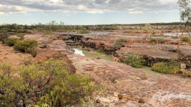
Situated in outback Queensland, Hell Hole Gorge National Park is a remote park 912km west of Brisbane and home to several waterholes and rockpools including Spencers Gorge and Hell Hole Gorge.
With no visitor facilities, the site is only accessible by four wheel drives and off road camper trailers, with the nearest town, Adavale, an hour’s drive away.
Locals of Adavale claim the ‘Hell Hole’ name comes from the site’s history of being the location of a large massacre of Aboriginal people who lived on the land and were allegedly shot and thrown in the gorge after the murder of settler Richard Welford.
Due to the isolated nature of Hell Hole Gorge National Park, only experienced campers and nature lovers are encouraged to visit the rocky terrains of the outback national park, with camping available at the nearby Powell Creek camping area.
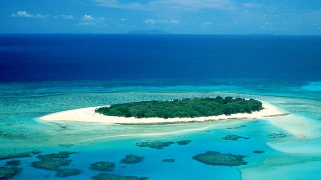
BIG WOODY ISLAND
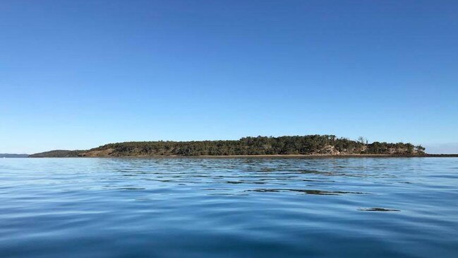
Just four kilometres off the east coast, located between Fraser Island and Hervey Bay is Big Woody Island, an ironically, small island along the Great Sandy Strait with a rich history.
Also known as ‘Tooliewah’ by the Butchulla people, Big Woody Island houses two twin lighthouses built in 1866 and 1868 named Middle Bluff and North Bluff Lighthouse.
Made from timber, both the lighthouses were instrumental in the early industrial development of Queensland, reflecting the state’s growth after its separation from New South Wales.
Big Woody Island is rumoured to have gotten its name from a Captain Matthew Flinders who named the island after the hardwood and timber nature all along the 660 hectare terrain.
While camping is permitted on the island, there are no facilities available, but the island is home to Jeffrey’s Landing, a white sand beach, accessible via a six hour tour to the island where visitors can fish, paddleboard, dive and snorkel.
Big Woody Island is not to be confused with the nearby and again, appropriately named, Little Woody Island.
Did we miss any? Take a look at some more rudely named streets, mountains and creeks below.
FUNNY STREETS
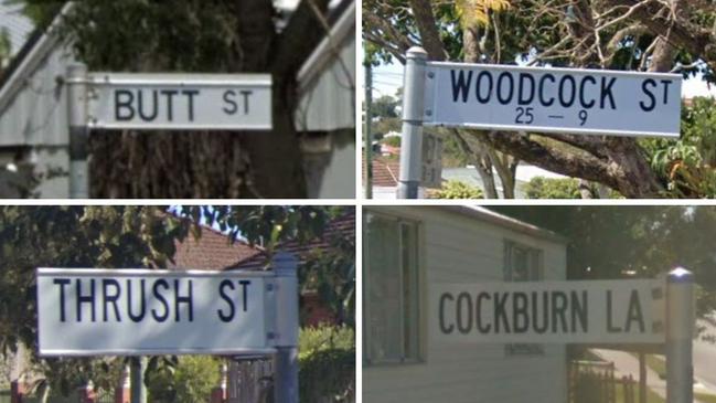
Bogan St, Albion
Bottomley St, Brassall
Butt St, Harristown
Cockburn Ln, Gympie
Hornibrook Esp, Clontarf
Nimrod St, Cooloola Cove
Thrush St, Inala
Wanka Rd, Cecil Plains
Weenah St, Bracken Ridge
Willi St, Rosenthal Heights
Woodcock St, Paddington
Woollybutt St, New Auckland
RUDE MOUNTAIN PEAKS
Bally Knob, Ravenshoe
Cleanskin Knob, Einasleigh
Mount Blowhard, Wowan
Mount Breast, Tarramba
Mount Cracknell, Porcupine
North Pimple, Ulogie
Punch Knob, Middleton
Shebas Breasts, Almaden
The Knob, Four Ways
The Twin Humps, Coen
Two Mile Knob, Gladstone
HUMOROUS CREEKS AND BEACHES
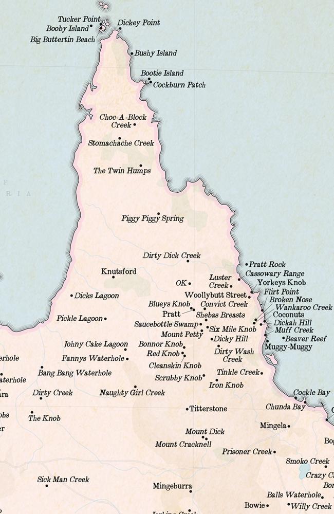
Big Buttertin Beach, Prince of Wales
Bogan Jack Creek, Old Cork
Bogan Waterhole, Taldora
Dingleberry Creek, Opalton
Dirty Dick Creek, Prospect
Fannys Creek, Dumgree
Fannys Waterhole, Gilbert River
Muff Creek, Midgereee Bar
Slaggy Creek, Ghinghinda
Titi Creek, Coonambula
Wee Beach, Mission Beach
Willie Creek, Upper Freestone
DO YOU KNOW SOME MORE? Comment below on places you have seen
Originally published as Mount Dick to Humpybong Creek: Queensland’s rudest named places exposed
Join the conversation
Police swarm Qld property after shots fired
Police have surrounded a rural Qld property where its understood shots have been fired, and officers are negotiating with a man inside.
Read more

Gold Coast youths terrified after dark: ‘You get chased by crackheads’
A stunning report has revealed young people are more scared than older residents to take public transport or walk Gold Coast streets after dark amid spiralling drug use and violence. READ WHY THEY ARE SO SCARED
Read more