
Northern NSW: Rain forecast for flooding areas
From Tweed Heads to Kempsey, the North Coast is getting inundated with rain with rivers peaking throughout Monday. A Bureau meteorologist tells when the rain is expected to end.

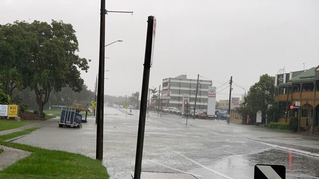
Tweed Heads
Don't miss out on the headlines from Tweed Heads. Followed categories will be added to My News.
From Tweed Heads to Kempsey, Northern NSW has been inundated with rain throughout the weekend with rivers set to peak, some to record-breaking heights throughout Monday.
Meteorologist Jordan Notara from the Bureau of Meteorology has explained what’s causing the weather system, when rivers around the north are expected to peak and what to expect for the week to come.
Tweed, Murwillumbah
The Tweed River has already caused major flooding in Tumbulgum, Murwillumbah and Chinderah.
Mr Notara said the river was set to peak at 5m in North Murwillumbah and 2m at Chinderah about 9am while Tumbulgum is expected to rise to 3.5m at 11am.
“The added impact broadly is it’s still generally raining quite heavily,” Mr Notara said.
He said the situation was dynamic and expected the rain would continue for the next 12 to 24 hours.
However he said river heights in the Tweed were not expected to reach the levels of ex-tropical Cyclone Debbie in March 2017.
Byron, Billinudgel, Mullumbimby
Byron Shire is seeing major flooding at Billinudgel and Mullumbimby with a number of flood locations across Marshalls Creek and the Brunswick River.

Mr Notara said Marshalls Creek was expected to peak at 4.2m and the Brunswick River at Mullumbimby at 5m about 10am Monday morning.
Like the Tweed, levels around Byron Shire are not historically significant.
Ballina
The coastal area of the Richmond River is seeing more minor flooding, however further up stream the flooding becomes more significant.

Mr Notara said the river levels were expected to exceed the 1974 record in what would be a historic flood event.
Moderate flooding is occurring at Casino and Woodburn. Minor flooding is occurring at Wiangaree. Major flooding is likely at Casino and Woodburn.
Flood peak times are expected all throughout the morning and into early afternoon.
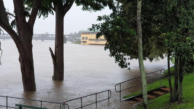
Lismore
Mr Notara said the situation in Lismore was serious with the CBD inundated with water and rain still falling.
He said Lismore was likely to reach a historic flood peak with impacts not seen often for the Northern Rivers’ town.
He said overnight rainfall had accumulated between 500mm to 700mm leading to an evacuation warning.

RELATED: Elderly man rescued in floodwater at Lismore
“Broadly what occurred was the system we’ve been tracking slowly moved into NSW, with a slow and steady accumulation of rainfall hour by hour,” he said.
He said there was still some uncertainty in the area that was looking similar to recent significant rainfall in Queensland.
Grafton
Mr Notara said the situation in Grafton was still evolving with warnings for heavy rainfall and damaging wind in place across the Clarence.
He said risks included trees becoming easily blown down from the soaked soil.

He said the Clarence River was causing flooding similar to March 2021 with major flooding in Grafton and moderate flooding in Maclean and Ulmarra.
He said peaks were expected early Monday afternoon, particularly downstream when the high tide was set to occur.
Coffs Harbour
Mr Notara said the biggest risk for Coffs Harbour was significant flash flooding.

He said the Coffs Creek was not being monitored at the moment as it was below the watch or warning criteria however there was risk of flash flooding occurring around the region.
He said this was expected to occur either late afternoon or late evening on Monday and for motorists to avoid the roads and to not drive into flood waters.
When will the rain end?
Mr Notara said rain should be easing towards the latter part of Tuesday, however that will not be the end of the flooding.
Following the rain easing he said storm activity was expected Wednesday and Thursday with shower activity in isolated pockets.
The risk following the rain was also flash flooding while Northern NSW waits for the water to drain which could take even longer.
He said the situation was being continually monitored and updated.
What’s causing this?
Mr Notara explained the rain event, which started in South East Queensland was caused by a combination of a slow moving low pressure system and a blocking high pressure system.
“The result of that is your typical progression of weather from west to east is blocked and the weather stalls around a region,” he said.
“The system itself is not able to process out to sea and is instead following down the coast line.”
He said that system was set to intensify as it travelled down towards the Central Coast, but as this system moved, storm activity and high moisture were likely for the North of the state.


‘Unplug, unwind’: Luxury Byron Bay retreat has everything you could ever want – except this
An adults-only retreat not far from the centre of the northern NSW tourist hot spot delivers the set up for a chilled-out weekend.

Meet the hopefuls battling to represent Page
Page is the seat to watch come election night but how well do you know the candidates? We help you decide as hopefuls share a range of insights from their political ideals to baking with the CWA and transgender sports.