
Lismore, Tweed, Grafton, ballina floods: Northern NSW threatened by severe storms after flooding
The Northern Rivers is likely to see little reprieve from devastating floods, as a new threat of thunderstorms looms over the region.
Tweed Heads
Don't miss out on the headlines from Tweed Heads. Followed categories will be added to My News.
There’s likely to be little reprieve for Northern NSW towns inundated with flood waters this week as severe storms threaten the region moving into Wednesday and Thursday according to the Bureau of Meteorology.
Meteorologist Jordan Notara said towns from Grafton north to the Queensland border were likely to be impacted by looming storms from Thursday onwards.
He said storms were likely to form around Casino and Tenterfield before travelling towards the north east of the state.
“These storms themselves are going to be slow moving could see an accumulation of rainfall,” he said.
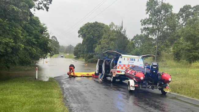
He said there was also risk of strong winds in excess of 90km/h, flash flooding and landslide potential across the entire Northern Rivers.
He said severe storms were expected from Wednesday afternoon and were likely to continue into Thursday with warnings to be released as required.
Here’s how each area will be impacted.
Ballina
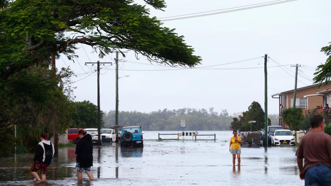
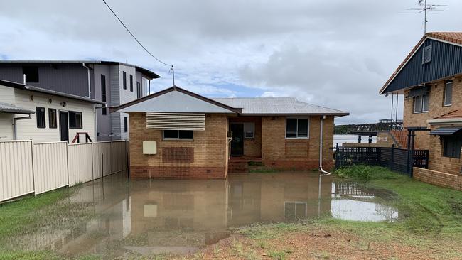
The Richmond River has begun to flow into the ocean on Tuesday following an evacuation in Ballina in the morning.
Mr Notara said there was still major flooding in the area, however the Bureau was not predicting a any widespread rainfall which could see a recurring peak.
He said the region would potentially be hit by heavy storm activity which would delay the true recession of the rivers.
Byron/ Mullumbimby
Byron Shire will have some reprieve as no further flooding is expected from the Marshall Creek.
Mr Notara said it was important to note there were some parts of the river however that were unable to be observed and the public keep aware of changes in their local area.
Byron also has a change of a late afternoon shower on Wednesday and severe thunderstorms on Thursday.
Lismore
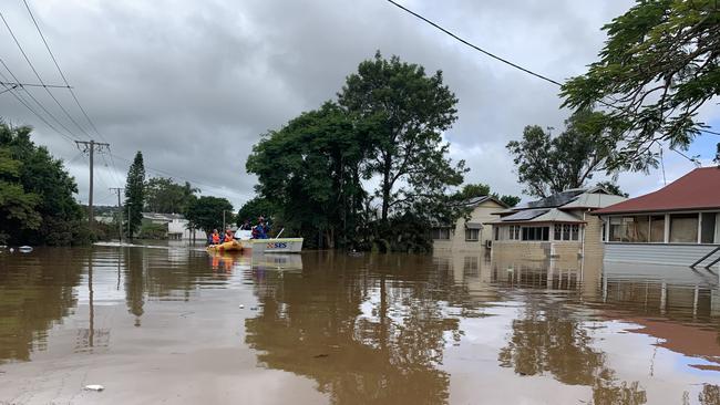
After breaking 1974 flooding records on Monday the threat of rain to the Northern Rivers town is not over.
Mr Notara said Tuesday had been the calm before the storm with threats of high speed winds, additional flooding and landslides were looming for Wednesday afternoon.
He said flash flooding was also likely with additional warnings set to be released throughout the afternoon.
“The calm is right now many ways,” Mr Notara said.
“Light showers around, not wide spread heavy rain.”
Severe thunderstorms are expected to continue into Thursday.
Tweed/Murwillumbah
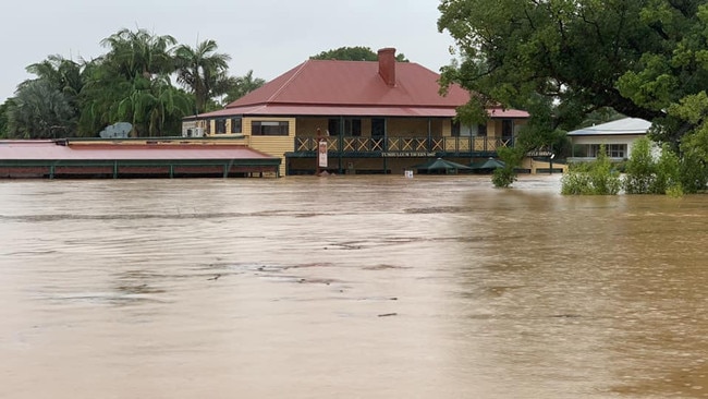
Conditions along the Tweed River have entered a receding phase according to Mr Notara.
The water levels beat the 1974 flooding record as the Murwillumbah levee overflowed on Monday.
However although water is going down, storms going into Wednesday afternoon threaten to top up the receding waterways – however not to the same level seen on Monday.
High speed winds and flash flooding are predicted to be risks to the area Wednesday and Thursday.
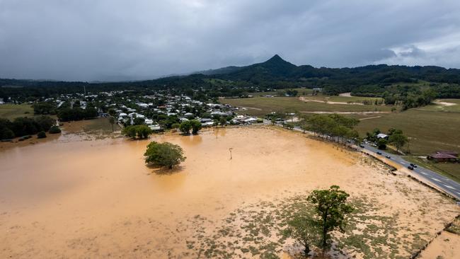
Grafton
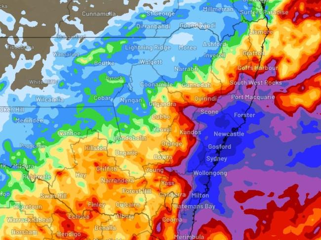
The Clarence has seen record breaking rainfall in several areas to 9am on Tuesday.
Yamba recorded 274.4mm on Monday, breaking the 1954 daily record of 270.5mm.
Grafton similarly broke a daily record at the Grafton research station recording 252mm on Monday, beating the 1921 record of 226mm.
Whiporie Post Office broke its 1974 record of 274mm on Monday, recording 297.4mm.
The Clarence also has threats of severe thunderstorms from Wednesday afternoon and throughout Thursday.
Mid-North Coast – Coffs Harbour, Port Macquarie, Kempsey
Additional rainfall is expected across the Mid-North Coast according to Mr Notara, however it will be more moderate than the north.
He said flash flooding remained a risk for low lying areas of Coffs Harbour, however there were no severe weather warnings in place.
Mr Notara said shower activity was expected to move onshore overnight on Tuesday with on and off periods of rain, typical for the area at this time of year.
What’s next?
Mr Notara said there wasn’t much rain relief in sight, with falls expected to continue over the next seven days.
“The complication is the more sunshine you get increases the risk of severe storms,” he said.
“We want to keep as much cloud as we can.”
He said the patches of sunshine can easily translate into the energy that generates thunderstorms.
“That being said, there is no clear day of note we will see clear skies,” he said.
“Similar to (Tuesday) there will be gaps every so often.”
He said the subsiding of flood waters would be subjective to how much rain the expect storms bring to the region and it was difficult to say how long it could take.


Trial climax: ‘Bashing the hell out of his woman’ or medical episode?
Despite a lengthy murder trial drawing to a close on Friday over the alleged brutal bashing death of a woman in a Ballina laneway, the Crown and defence were still at odds on a number of glaring issues.

Horseplay: Man who had sex with pet mare sentenced
A man now living on the Qld-NSW border who sexually assaulted his pet horse on multiple occasions at a Bega Valley farm, has been sentenced for the disturbing offending. See the video.