
Tropical Cyclone Kirrily: Northern NSW keeping close eye on weather after devastating 2022 floods
Fears of a major North Coast battering from flow-on effects of Tropical Cyclone Kirrily have eased – but experts warn residents should stay alert with heavy rain set to drench catchments.
NSW
Don't miss out on the headlines from NSW. Followed categories will be added to My News.
Fears of a potential “worst-case scenario” lessened on the North Coast when a cyclone brewing off the Far North Queensland coast changed its course.
Earlier in the week, Tropical Cyclone Kirrily stirred up concerns as experts warned it could spell disaster for northern NSW, which still bears the scars from 2022 floods.
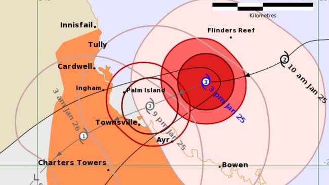
However, a spokeswoman from the Bureau of Meteorology (BOM) said the cyclone is now forecast to move further west and potentially towards the Northern Territory.
That means there should be less widespread rainfall throughout northern NSW.
While concerns have eased, there is still the likelihood of storms over the weekend, with isolated pockets of heavy rain across NSW’s northeast.
Tweed Shire Council director of engineering David Oxenham said council would continue to monitor the situation over the long weekend.
Many local governments in the north are also keeping a close eye on the situation.
“While predicted rainfalls have lessened, it is still likely we may receive heavy isolated falls with localised flooding and severe thunderstorms,” Mr Oxenham said.
“Residents are urged to be safe on the roads and keep across their usual weather information channels.
“We know our waterways are swollen after all the rain we have had so far this year already.
“Check our flood monitoring cameras for near-live images at key road crossings and sign up for our flash flood alert if you live at Burringbar, Mooball or Crabbes Creek.”
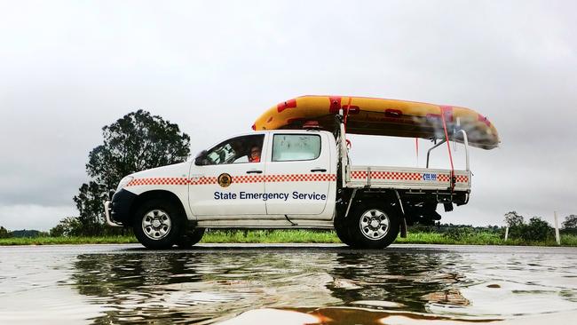
For help in floods and storms phone the NSW SES on 132 500, or triple-0 in a life-threatening emergency.
Earlier: North Coast keeping close eye on brewing cyclone
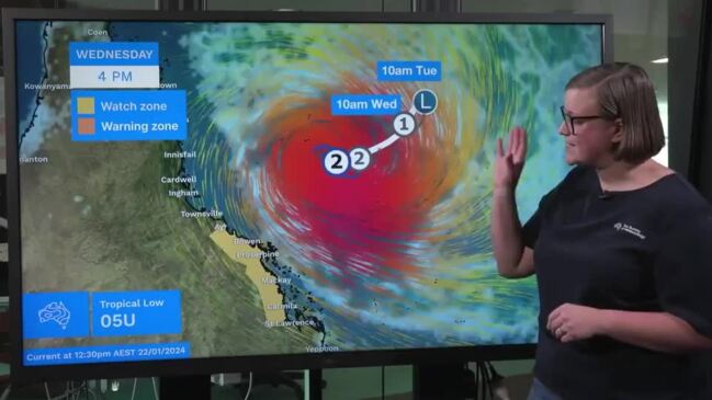
Tuesday, January 23: A severe cyclone brewing off the Far North Queensland coast is a little too close for comfort for Northern Rivers residents, who two years on still bear the scars from one of the worst natural disasters to ever hit Australia.
Despite no official word from the weather bureau whether Tropical Cyclone Kirrily will hit northern NSW, there is no denying expert warnings that it will wreak havoc wherever it makes landfall.
Kirrily is expected to hit shore late Thursday or early Friday before turning and making its way south and out to sea.
A senior meteorologist at the Bureau of Meteorology (BOM) Jordan Notara described the current situation for northern NSW as “covered in uncertainty”.
“It isn’t easy to say what and when anything is going to happen,” he said.
Mr Notara said the North Coast could see potentially heavy rain by Saturday, with the actual storm system arriving in following days.

The cyclone threat has southeast Queensland on edge. The Gold Coast is still in recovery mode after its fatal Christmas night storm.
BOM states it’s not yet known how intense the cyclone will be when it makes landfall, but it will be severe.
Some weather pundits have estimated a whopping 700mm of rainfall in northern NSW, while Queensland Premier Stephen Miles warned of “models predicting almost a metre of rain” in his state.
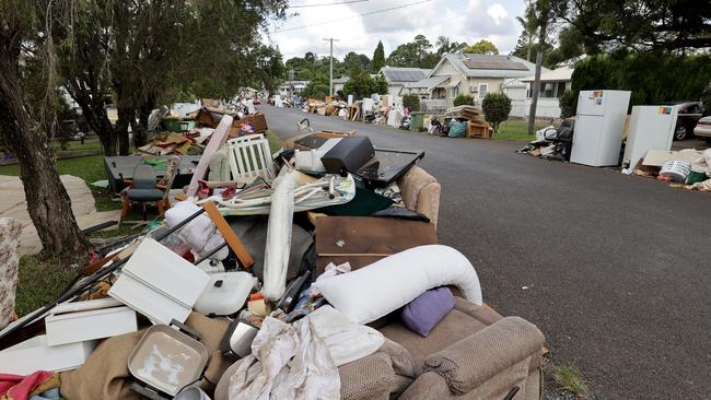
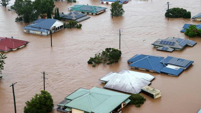
Two years on from the devastating 2022 northern NSW floods, which claimed the lives of five people and caused close to $1bn in damage in Lismore alone – councils are doing what they can to be prepare for a “worst-case scenario”.
Lismore MP Janelle Saffin said she was in touch with NSW State Emergency Service first responders in the North East Region on Monday, who were in planning mode.
“I’m with the NSW Reconstruction Authority in our region in my role as Parliamentary Secretary for Disaster Recovery and have been in regular contact with relevant ministers as a tropical cyclone watch has been issued for North Queensland,” she said.
“The best thing people can do here in northern New South Wales is to prepare yourself and be out of harm’s way.”
Tweed Mayor Chris Cherry said modelling was “definitely concerning” given much of the Tweed was still saturated from recent rainfall.
“A few weeks ago we had 700mm of rain out at Limpinwood over a two-and-a-half day period. The shire is already saturated so if we got 700mm in 24 hours it would definitely be cause for concern,” she said.
“I think it’s important for residents to be on alert and prepare for a worst-case scenario no matter what happens with this.
“We will be watching things closely over the next 24-48 hours to see if those predictions do firm up.”
Cr Cherry said: “The three things we saw in 2022 that were important in terms of preparation were stocking pantries, withdrawing cash and filling up your car with fuel.”
“I urge everyone to be prepared with the basics just in case,” she said.

The council provides updates through its online emergency dashboard, a site Cr Cherry called a “one-stop shop” for residents in the shire.
A NSW SES spokesperson said they were closely monitoring the formation of Kirrily and would be attending an emergency briefing with Queensland Fire and Emergency Service (QFES) on Tuesday.
“NSW SES has commenced planning for any impacts from the cyclone,” the spokesperson said.
“This involves working closely with our zones and local units, along with partner agencies, to prepare for any potential impacts NSW may experience.
“This may include propositioning personnel and assets should the need arise.
“We will continue to monitor the situation closely with the BOM and will provide warnings to the community as required.”
The spokesperson said there was “no current threat to NSW residents” but urged the public to plan ahead.
“Simple things like trimming trees around your properties, putting away loose items, and having discussions with your family and friends about what you will do in an emergency if you ever need to evacuate,” they said.
“Preparing an emergency kit and a grab and go bag which contains important documents, torches, medicines, drinking water and a portable battery-operated radio.”

Join the conversation

Teen charged over alleged role in Nordic cash for killing operation
A Sydney teen is facing the prospect of life in jail after he was allegedly caught trying to recruit people to commit contract murders across northern Europe in exchange for cash.
Read more

Paddington P-plater allegedly caught speeding three times in a day
The teen had her black Jaguar F-Pace confiscated by police on Saturday, after she was allegedly busted speeding down the Hume Highway three times in three hours.
Read more